Interstate 580 (Nevada)
| Basic data | |
|---|---|
| Length: | 4.99 mi / 8.03 km |
| State: |
Nevada |
| Course direction: | North South |
| map | |

|
|
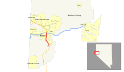
The Interstate 580 (abbreviated I-580 ) is an interstate highway in northwestern Nevada . As a feeder to Interstate 80 , it connects to the Interstate Highway system in Reno , but is not officially signposted and uses the route of US Highway 395 .
course
Interstate 580 begins south of Reno on Neil Road . It passes the Atlantis Casino Resort in the west and Reno-Tahoe International Airport at exit 65 in the east . After eight kilometers, I-580 ends at the intersection with Interstate 80 northeast of downtown near Governors Bowl Park .
Planning
Two expansion projects are to extend the highway to the southern city limits of Carson City , the capital of Nevada.
Web links
Commons : Interstate 580 - collection of images, videos, and audio files
- Interstate Guide (English)
- Nevada @ AARoads route description with photos
- Freeway Extension Project of the I-580 (English)

