
Cameras
| coat of arms | Germany map | |
|---|---|---|

|
Coordinates: 52 ° 45 ' N , 12 ° 7' E |
|
| Basic data | ||
| State : | Saxony-Anhalt | |
| County : | Stendal | |
| Association municipality : | Elbe-Havel-Land | |
| Height : | 25 m above sea level NHN | |
| Area : | 67.84 km 2 | |
| Residents: | 1215 (Dec. 31, 2019) | |
| Population density : | 18 inhabitants per km 2 | |
| Postal code : | 39524 | |
| Primaries : | 039382, 039383 | |
| License plate : | SDL, HV, OBG | |
| Community key : | 15 0 90 285 | |
| Association administration address: | Fontanestraße 6 39524 Schönhausen (Elbe) |
|
| Website : | ||
| Mayor : | Arno Brandt | |
| Location of the municipality of Kamern in the district of Stendal | ||
  |
||

Kamern is a unified municipality and a state-recognized resort in the northeast of the district of Stendal and Saxony-Anhalt in Germany. It belongs to the Elbe-Havel-Land association, which has its administrative seat in the municipality of Schönhausen (Elbe) .
geography
The municipality of Kamern is located on the northern edge of the Land of Schollene , a wooded terminal moraine arch that extends over a length of 30 km between the rivers Elbe and Havel, which run parallel here . Immediately south of Kamern, the Harkenberg rises up to 110 m above sea level in the Kamerschen or Rehberger Mountains . NN, this landmark is around 80 m above the flat floodplain landscape of the Elbe and Havel. Kamern is about 13 kilometers from Havelberg .
Kamern is surrounded by the neighboring communities of Havelberg in the north and north-east, Schollene in the south-east, Klietz in the south, Arneburg in the south-west, Hohenberg-Krusemark in the west and Sandau (Elbe) in the north-west.
Community structure
The districts of Hohenkamern, Neukamern, Rehberg, Schönfeld and Wulkau belong to Kamern .
history
The former Gutsdorf Kamern was first mentioned in a document in 1322. The Hohen-Kamern estate belonged to the von Katte family until 1945 , who bought it back in 1991.
On September 30, 1928, the main part of the Hohenkamern manor district was combined with the rural community of Kamern and the three-hectare exclave of the manor district with the rural community of Warnau.
With the municipal reform and the requirement to guarantee a minimum population of 1000 in unified municipalities, the previously independent municipalities Schönfeld and Wulkau joined the municipality of Kamern on January 1, 2010.
religion
36% of the population are Protestant, only 1% Catholic. The Protestant parishes of Kamern, Rehberg, Schönberg and Wulkau belong to the parish of Sandau in the Stendal parish of the Evangelical Church in Central Germany . The Catholics are assigned to the parish of St. Elisabeth , based in Tangermünde , which belongs to the Stendal deanery of the Magdeburg diocese ; The next place of worship is the chapel of Sandau Castle.
politics
Municipal council
The municipal council elections on June 14, 2004 saw the following results:
- four individual mandate holders with a total of 27.1%
- CDU 24.6%
- AWK 24.4%
- SPD 12.7%
- The left 11.1%
Local election 2014:
The municipal council has 13 members.
mayor
In 2014 Arno Brandt was elected to succeed Klaus Beck.
Logo and historical coat of arms
The municipality does not have an officially approved coat of arms; it only has a logo similar to a coat of arms.
The former communities of Kamern and Rehberg already had a coat of arms-like seal image in their community seal. This was used in the period after the Second World War until about the introduction of the districts and counties in the GDR (1945–1952). Another source is the County Home Museum in Genthin.
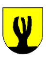
Logo Kamern
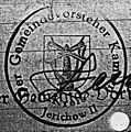
old seal of the municipality of Kamern

old seal of the community Rehberg


Economy and Infrastructure
traffic
The municipality of Kamern is located on the highway from Havelberg to Rathenow in Brandenburg and is connected to the federal highway 107 (Havelberg - Genthin ) via the neighboring municipality of Wulkau . The nearest train stations are over 20 km from Kamern ( Schönhausen (Elbe) , Rathenow and Glöwen ). Regular buses and on-call buses run by Regionalverkehr Westsachsen (RVW) under the brand name stendalbus .
Sports
Kamern is one of the Altmark hiking nests that are organized in the Altmark hiking club.
Web links
Individual evidence
- ↑ State Statistical Office Saxony-Anhalt, population of the municipalities - as of December 31, 2019 (PDF) (update) ( help ).
- ↑ Administrative region of Magdeburg (Ed.): Official Gazette of the Government of Magdeburg . 1928, ZDB -ID 3766-7 , p. 223 .
- ↑ StBA: Area changes from January 01 to December 31, 2010
- ↑ 2011 census
- ↑ Archived copy ( memento of the original from April 26, 2017 in the Internet Archive ) Info: The archive link was inserted automatically and has not yet been checked. Please check the original and archive link according to the instructions and then remove this notice.
- ↑ http://www.volksstimme.de/nachrichten/lokal/havelberg/1400620_buergermeister-haben-neu-gewaehlt.html
- ↑ http://www.wanderverband.de/conpresso/_data/Altmaerkischer.pdf
Aland | Altmark Height | Altmark wipes | Arneburg | Bismark (Altmark) | Eichstedt (Altmark) | Goldbeck | Hassel | Havelberg | Hohenberg-Krusemark | Iden | Kamern | Klietz | Osterburg (Altmark) | Rochau | Sandau (Elbe) | Schollene | Schönhausen (Elbe) | Seehausen (Altmark) | Stendal | Tangerhütte | Tangermünde | Advertise (Elbe) | Wust-Fischbeck | Zehrental