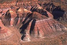
Kane County, Utah
| administration | |
|---|---|
| US state : | Utah |
| Administrative headquarters : | Kanab |
| Foundation : | 1864 |
| Demographics | |
| Residents : | 7125 (2010) |
| Population density : | 0.7 inhabitants / km 2 |
| geography | |
| Total area : | 10,641 km² |
| Water surface : | 302 km² |
| map | |
Kane County is a county in the state of Utah in the United States . As of July 1, 2005, Kane County had 6,202 residents. The county seat is Kanab , the largest city in the county.
geography
According to the US Census Bureau, Kane County covers an area of 10,641 km², of which 302 square kilometers are water. The southern border of the county forms the border with the state of Arizona . The county is bordered clockwise by the counties: Garfield County , San Juan County , Coconino County Arizona, Arizona, Mohave County Arizona, Arizona, Washington County, and Iron County .
history
Kane County was named after Col. Thomas L. Kane. He was a friend of the Mormon settlers. The county was founded in 1864.
Demographic data
| Population development | |||
|---|---|---|---|
| Census | Residents | ± in% | |
| 1870 | 1513 | - | |
| 1880 | 3085 | 103.9% | |
| 1890 | 1685 | -45.4% | |
| 1900 | 1811 | 7.5% | |
| 1910 | 1652 | -8.8% | |
| 1920 | 2054 | 24.3% | |
| 1930 | 2235 | 8.8% | |
| 1940 | 2561 | 14.6% | |
| 1950 | 2299 | -10.2% | |
| 1960 | 2667 | 16% | |
| 1970 | 2421 | -9.2% | |
| 1980 | 4024 | 66.2% | |
| 1990 | 5169 | 28.5% | |
| 2000 | 6046 | 17% | |
| 2010 | 7125 | 17.8% | |
| Before 1900
1900-1990 2000 |
|||
According to the 2000 census , Kane County's population was 6,046. There were 2,237 households and 1,628 families. The population density was 1 person per square kilometer. The racial the population was composed of 96.00% White, 0.03% African American, 1.55% Native American, 0.22% Asian, 0.05% Pacific Islander, and 0.74% other races Groups; 1.41% from two or more races. 2.32% of the population were Hispanic or Latino of any race.
Of the 2,237 households, 32.20% had children and young people under the age of 18 living with them. 64.60% were married couples living together, 6.00% were single mothers. 27.20% were not families. 23.30% are single households and 10.20% have someone who is 65 years of age or older. The average household size was 2.67 and the average family size was 3.21.
For the entire county, the population was composed of 29.40% of residents under 18 years of age, 6.80% between 18 and 24 years of age, 21.20% between 25 and 44 years of age, 25.90% between 45 and 64 years of age 16.70% were 65 years of age or over. The median age was 39 years. For every 100 females there were 98.30 males, and for every 100 females aged 18 and over there were 94.10 males.
The median income for a household in the county is $ 34,247 , and the median income for a family is $ 40,030. Males had a median income of $ 30,655 versus $ 20,406 for females. The per capita income was $ 15,455. 7.90% of the population and 5.50% of families are below the poverty line. 9.30% of them were under 18 years of age and 5.40% were 65 years of age or older.
Places in Kane County
Rivers
The county is the watershed between the Colorado River system and the Great Basin . This is where the Sevier River and its tributary East Fork Sevier arise to the Great Basin and from east to west the Paria River , Kanab Creek and the two headwaters of the Virgin River North Fork Virgin and East Fork Virgin to the Colorado River.
Individual evidence
- ↑ Kane County in the United States Geological Survey's Geographic Names Information System . Retrieved February 22, 2011
- ^ US Census Bureau _ Census of Population and Housing . Retrieved February 28, 2011
- ↑ Extract from Census.gov . Retrieved February 28, 2011
- ↑ Excerpt from factfinder.census.gov.Retrieved February 28, 2011
Web links
Coordinates: 37 ° 17 ' N , 111 ° 53' W


