
Zwentendorf Castle
| Zwentendorf Castle | |
|---|---|
| Alternative name |
Asturis ?, Piro torto ? |
| limes | Limes Noricus |
| section | Route 2 |
| Dating (occupancy) |
late Flavian , 1st to 5th century AD |
| Type |
Cohort fort , square complex with rounded corners, surrounded by three trenches, extensive adaptations in late antiquity |
| unit |
a) Legio II Italica b) Cohors V Breucorum c) Legio I Noricorum d) Cohors I Asturum (?) |
| size | 161 × 131 m, approx. 2.2 ha |
| Construction |
a) Wood and earth fort. b) Stone fort |
| State of preservation | Soil monument no longer visible above ground, north-east part completely removed by the Danube |
| place | Zwentendorf |
| Geographical location | 48 ° 20 '33 " N , 15 ° 54' 50" E |
| Previous | Augustianis Castle (west) |
| Subsequently | Comagena Castle (east) |


Zwentendorf Castle was part of the fortress chain of the Roman Danube Limes in Austria and is located in the state of Lower Austria , Tulln district , Zwentendorf municipality .
The area of the auxiliary troops fort ( Auxilia ), which is only preserved in its south-western area, was partially exposed and examined in the course of an excavation that lasted several years at the end of the 1950s and the beginning of the 1960s, then filled in again. It is one of the best-researched Limes forts in Austria. Together with the camp, the article also covers the two watchtowers of Maria Ponsee .
Surname
In the Tabula Peutingeriana on the route Vindobona - Lauriacum there is a station called Piro torto , which was 8 Roman miles from Commagenis and Trigisamum . The ancient name of the fort was initially equated with Piro torto ( Friedrich von Kenner , M. Klein, Eduard Zenker). It was initially u. a. also suspected at Pischelsdorf.
Kurt Hetzer first suggested locating Piro torto near Zwentendorf / Krottendorf, as this point was about 12.3 km from Tulln and 11.2 km from Traismauer . It is also in the middle of the so-called three "Bierbaumgemeinden" ( Moosbierbaum , Oberbierbaum and Bierbaum am Kleebühel ). Bierbaum actually means pear tree and Piro torto could therefore be translated as "curved pear tree" in Hetzer's opinion. However, he was unable to provide any solid evidence for this thesis.
Franz Ertl even tried to lead Favianis into the meeting, since u. a. the naval unit stationed in the fort of the same name would have found a good base of operations there and the orchards there are also mentioned in the Severinsvita . In the vita, however, the " oppidum Asturis " is also mentioned, in which Severin is said to have stayed for a short time.
Due to the numerous finds of brick stamps of the cohors I Asturis , Herma Stiglitz adopted the name Asturis for the Zwentendorfer fort. Piro torto is not mentioned in the Notitia Dignitatum (ND). For Stiglitz it was just a station of the state courier service ( cursus publicus ) , from which the names of the three beer-growing locations may have been derived. The decisive factors for them were also the size of the fort, which was designed for 500 men (cohors quinquenaria) , the location west of Cannabiaca and the fact that the Severinsvita reports on the complete destruction of Asturis around 500 AD. However, this theory is not unanimously recognized in the professional world. A lead label ( Tessera ) found in Zwentendorf names a standard bearer ( Signifer ) from Asturis .
location
The community of Zwentendorf is located approx. 13 km west of the district capital Tulln, directly on the banks of the Danube. The fort area comprises a field and the edge of a small wooded area, called “Remise” or “Weingartl”. This is located about 1.5 km west of the town center and the banks of the Danube after the junction to the Zwentendorf nuclear power plant, between Bundesstraße 226 and the Wagram . Above ground nothing can be seen of the fort, its remains uncovered by archaeologists had to be filled in again after the excavation campaigns in the 1950s and 1960s, as the area is used for agriculture. In Roman times, the fort was located on a two meter high, protected from flood, sloping lower terrace to the north, as can still be seen today from a clearly recognizable terrain, directly on a former bank of the Danube, which over the centuries also formed the northern half of the Has completely washed away the fort area. In ancient times, the bank of the main stream was in the immediate vicinity, so that one had direct access to the Danube from the fort and at the same time was protected by the marshy and therefore difficult to cross floodplains.
Road links
From the south gate, the road led to the Limes Road, which continued further south from Vindobona via Tulln ( Comagena ) to Traismauer ( Augustianis ) and Mautern ( Favianis ) or Sankt Pölten ( Cetium ). Another road led from the south-west corner of the fort to the south-west, another side road ran past the fort in the south-east. The Roman road network around Zwentendorf could not be precisely located until today. However, it is certain that the fort was involved.
function
Together with the neighboring forts of Comagena (Tulln) and Augustianis (Traismauer), the occupation of Zwentendorf - in addition to monitoring the border and relaying information - was primarily responsible for securing the traffic routes in the Tulln Basin. Important roads from the north (from the Bohemian Forest and from Wagram ) and south (Alpine foothills) met at the fort and continued towards the Danube valley.
Research history
19th century
St. Neill carried out the first superficial investigations on the area in 1883 and found that although no Roman ruins were found over the course of days, "... round, strong masonry ..." was present. According to a report by the village teacher from Zwentendorf, Anton Zündel, even larger remains of a medieval tower ruin (“ Krottenturm ”) were visible in the so-called Weingartl forest . Also on the Schweickhart map from 1831 is u. a. a building marked west of Zwentendorf, which presumably marked the location of this facility. In the Franziszeischen Cadastre (1817–1861) on the sheet for Zwentendorf, parcel 729 is given as “Grottenthurm Braiten”. The remains of the wall were blown up by the estate administration towards the end of the 19th century in order to make the property usable as a vineyard. The vernacular reported that rich treasures were supposedly buried and still had to be found there. But only a few finds of Roman coins are known. Roman graves have also been discovered here and there. Anton Zündel suspected a Roman military camp there. The existence of a fort in this section was not in principle questioned by experts, but it was suspected in Piro Torto , which was equated with Pischelsdorf . Only a Roman civil settlement was assumed for Zwentendorf.
20th century
After the end of the Second World War, Austrian Limes research returned to the immediate vicinity of Zwentendorf. Increased on the area around the so-called Weingartl. In 1950, Hans P. Schadn drew a "local mountain with built-in walls and prehistoric finds in Zwentendorf an der Donau (Krottendorf)" in his local mountain map in the west of Zwentendorf. This object was also published by F. Halmer in 1948 as the “Krottenturm” or “Vanished Castle”. Otto Biack also initially suspected masonry from Roman times there, but later rejected the existence of a Limes fortification in this region. From 1953 the Federal Monuments Office had numerous search cuts excavated. This was followed by excavations under the direction of Herma Stiglitz (Austrian Archaeological Institute with the support of the Lower Austrian State Museum), which clarified the scope and construction phases of the fort. In 1952, during renovation work on the parish church of Zwentendorf, two Roman reliefs came to light, depicting a hunting scene and a funeral meal. This stroke of luck and the closer exploration of the site by Kurt Hetzer, who had reported such finds to the Lower Austrian State Museum even before the Second World War (Hetzer repeatedly pointed out the numerous finds of Roman ceramics and pieces of brick in the Weingartel), gave the impetus for the first systematic scientific investigation of the site in 1953 by the Prehistory and Protohistory Department of the Lower Austrian State Museum in cooperation with the Austrian Archaeological Institute . Herma Stiglitz, Franz Hampl and Eduard Vorbeck set themselves the goal of discovering the fort, a burial ground from the 10th-11th centuries. Century and medieval fortifications excavated. These excavations dragged on until 1962. In order to be able to present the large number of finds appropriately, the museum in Zwentendorf was opened especially in June 1963. The results of the Stiglitz campaigns were published extensively in 1975 as part of the publication Der Römische Limes in Österreich , Issue XXVI.
In 1981, under the supervision of the Federal Monuments Office , some surface finds (horse brooches, coins, lunula pendants, bronze spoons, bronze pine cones and ceramic shards) were picked up in the area of the camp, which are now in private hands. In 1994 aerial photographs of the former fort area were made. Their evaluation showed a road leading out of the south gate and the vicus south and west of the camp. In addition, the course of a third weir ditch could be followed, which was built 35 meters away from the two already known moats.
21st century
In the years 2001 to 2005 Archeo Prospections was commissioned to scan the area in the southwest of the fort as well as grid squares to the west, southwest and south (approx. 9.8 ha) using georadar. The aim of these measurements was to compare the results with other vicus findings and the like. a. to use in Mautern . In addition to the street already mentioned, which led out of the south gate, the evaluation showed a few other side streets; this was followed by the camp service, which was clearly subdivided into parcels. 280 meters south of the fort gate, smaller grave structures could be seen as rectangular masonry, all along the main road. In 2005 another investigation was carried out on an area of eight hectares south of the fort along the route leading to the Limes Road. The evaluation of the approximately 4,000 finds (mainly ceramics) allowed conclusions to be drawn about the use of the settlement and burial ground areas in the middle imperial period and also in late antiquity. Up until 2007, numerous important findings about other structural details of this fort could be gained through further excavation campaigns.
development
Due to the coin finds ( Galba and Domitian ) under the Flavian emperors ( Vespasian , Titus and Domitian), the fort was probably built in the second half of the 1st century AD. This period is considered to be secure, as a fibula and chain armor from the 1st century could be recovered from the cellar of the principia . The wood-earth camp (of which only one well shaft - well 1 - and the south gate could be proven) did not last long.
The conversion into a stone warehouse was probably carried out quickly and without any significant disruptions. On the basis of the finds in the burial of the above-mentioned cellar and a coin of Trajan (112 AD) discovered in the camp, Herma Stiglitz suspects this to be at the beginning of the 2nd century AD. The new building probably stood with the large-scale relocations of troops, the Trajan in Noricum and Pannonia at this time for his Dacer Wars , in connection. In the following - very quiet - period of time, some adaptations were made, which can be read mainly from the principia (rooms B and C). The end of this peace period is marked by a layer of fire, which could be seen particularly well on the barracks. The next large-scale construction work took place around 200 AD. Due to the crushed layers of fire and mud huts, the camp is likely to have suffered severe damage again in the Marcomann Wars.
In the course of the military and administrative reforms under Diocletian and Constantine I, the fortifications were also modernized. The last time it appears that the camp was made major modifications due to the division of the army into Limitanei and Comitatenses . However, it is extremely difficult to answer the question of exactly when this last major renovation phase (stone period II) can be dated. Stiglitz favors the period between the rule of Constantine I and Valentinian I. The numerous fortress buildings and reconstructions under Constantine on the Rhine border, for example, consist of round towers. A certain preference for this area under this emperor can also be determined. Valentinian came from Pannonia and made great efforts to strengthen the Danube Limes again, which is why he often stayed in this region. The gradual transformation of the forts into fortified villages, which can often be observed in Noricum, can also be clearly demonstrated in Zwentendorf. The last structural changes to the fortifications at the time of Theodosius I were only makeshift repairs and adjustments to meet the needs of a largely autonomous settlement. Based on the observation of a larger layer of fire and various ceramic shards, research assumes a violent destruction of the oppidum in the late 5th century, for which Eastern Gothic latrones (looters) could have been responsible.
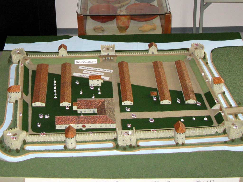
Fort


| Model in the Heimat- und Industriemuseum Zwentendorf, condition around 300 AD |
|---|
| Erich Marschik , 2017 |
|
Link to the picture |


Since the area of the storage area was never built over due to the intensive agricultural use, considerable remains of the facility were preserved. The square floor plan of the fort is strongly warped towards the west in order to adapt it as best as possible to the topography of the time. The excavations on the western horseshoe tower showed that an arm of the Danube originally passed there.
A total of three construction phases could be identified. The interior structures, barracks and a building complex interpreted as a principia (staff building) were also multi-phase. The late antique interior development no longer followed the previous scheme and was predominantly civil in character. The late antique adaptations to the fortifications that are typical for Noricum can be recognized by means of two fan, three horseshoe towers and a rectangular, bastion-like building in place of the south gate. In addition, a grave field from the 10th-11th centuries was found in the fort area. Century (coin of Boleslaw II, died around 999) and a medieval fortification (the "Krottenturm" mentioned above) was discovered.
Wood-earth period
Wall and moat systems
The north-south extension of the first Zwentendorf fort, including the moat, was approximately 100 meters. The west-east orientation is assumed to be 154 meters. In the 1950s it was found that the first late Flavian wood-earth fortification formed a typical (albeit strongly warped) rectangle and on its west, south and east side of a 5-7 meter wide and 1.70 meter deep ditch was surrounded. This ran diagonally from northwest to southeast and thus probably exactly followed the course of a now silted arm of the Danube. It was 7 meters wider and 1.70 meters deeper than its successor. Presumably it carried groundwater (comparison with storage wells) and probably accelerated the washing away of the northern fort area, since the demolition of the terrain begins there. The earth wall that was heaped up with the trench was almost vertical on its inside and thus much steeper than on its outside. The battlements were made of wood. Stone material such as the Murus Gallicus was not used. This is proven by the leveling layer of the following period (stone period I), which consisted only of humus .
Gates and towers
Of the gates, only the southern one, approximately in the middle of the wall, with a 1.80 meter wide and 5 meter long passage could be detected. The gate towers and a gate shoring from stone period II and III were also located there. It is assumed that the camp had no gates in the east and west. In the west no interruption of the moat could be observed. This also happened with other Limes forts such as the wood-earth period of the Saalburg fort. Herma Stiglitz suspects a smaller gate in the north that could have served as access to a mooring on the banks of the Danube.
Interior constructions
Only post holes and beam imprints remain of the internal structures. A cellar from the time of the first wood-earth system could only be identified under the principia of Stone Period I. It consisted of two rooms, the larger of which was about two feet lower than the smaller. The basement was originally boarded with wooden boards (spruce and oak). Access should only have been possible through a trap door and a ladder. Another cellar could be observed in the western part of the camp.
Stone period I
In the middle of the 2nd century AD the wood-earth store was removed; its fortifications were rebuilt in stone, presumably at the same time as those of the neighboring forts. The layout of this camp was more regular, but also slightly shifted due to the terrain on its broadside to the Danube in the southwest. With its area it again took up the circumference of the wood-earth camp, but had a greater west-east expansion. With the help of the preserved foundation walls of two barracks from a later period, despite the lost, estimated 35 meter long northern section, an area of 160 × 131 meters, that is more than two hectares, can be assumed (dimensions without ditches). The reason for the enlargement of the camp may have been the replacement of the former main force. According to Herma Stiglitz, the Roman engineers seem to have used the Illyrian-Macedonian foot (27.2 cm), which is rather unusual in this region.
Fort wall
It consisted of a 1.10 to 1.15 m wide quarry stone wall (height about four meters, calculated according to the depth of the trench), the foundation depth of which, at just 0.60 m, was noticeably small with regard to the trenches in front. The foundations had not been reinforced in the area of the trenches of the wood-earth fort either. This posed the risk of subsidence and cracks in the masonry. The fortifications on the east and west sides were probably completed first. During this work, the old earthworks continued to guarantee safety. After the north-south ramparts were built, the trenches of the wood-earth fort located inside the camp were leveled with demolition material. Whether an earth wall was also built up behind the wall could no longer be proven archaeologically, but it is very likely. The shape of the corner towers also speak in favor of this. The foundations consisted of unprocessed pebbles, their lowest layer was laid pebbles without mortar bonding. In the absence of clear findings, one can only speculate about the appearance of the wall crown. But it will not have differed significantly from those of the other forts on the Limes. From the early wood and earth fort, only the south wall was included in the new fortifications. On its east and south side there were two moats, on the west side only one, each 4.60 to 6.50 m wide and 2.40 to 3 m deep, which were apparently flooded with water. The width of the berm was about 2.40 m.
Gates and towers
The corners of the camp were rounded and reinforced on the inside with attached towers. The foundation of the southwest corner tower was still well preserved, it reached deep into the natural ground. Apparently, heavy ballistic cannons were also set up in this tower .
The south gate of the wood and earth fort now acted as the main gate. It was secured by two square flank towers, mostly protruding inward and measuring 4 × 3 m. They were later removed when the late antique fort was built. From the west the foundation could still be proven, from the east only the foundation pit. The width of the passage was approx. 8 m, with a supporting pillar ( spina ) in the middle . Traces of the gravel substructure remained from the arterial road.
On the east and west side, no gates could be found, but a massive rectangular intermediate tower. Its dimensions were 3.40 × 4.60 meters, the wall was 80 centimeters thick. The screed floor of the basement, about twelve centimeters thick, was still well preserved. It is noticeable that the foundation thickness on the camp wall is 1.40 meters, but on the east wall of the tower is 2.40 meters. Presumably this tower was also armored with heavy guns. The soil above the screed consisted of humus and not of " hut clay " like that from the neighboring exploratory cuts. This proves that it was probably used until late antiquity. On the east wall, too, there were wall remains of an intermediate tower attached to the inside.
Interior constructions
Connected to the fortifications, the interior structures were also completely rebuilt. Only small remains of the barracks have survived, as they were built over by buildings from Stone Period II. It was almost certainly not a question of stone buildings, but of the half-timbered buildings with tiled roofs that are common in forts of this type. In barracks block E, the rubble of a roof collapse was recovered, which was stamped by the brickworks of the legio II Italica . These are dated to the last third of the 2nd century, as they do not yet contain the honorary name " pia fidelis ", which this legion only led from 193 AD. These barracks probably had the same orientation as their predecessors in the wood-earth fort.
In the south-west sector, the complex of the principia, which had been rebuilt several times, also came to light. Mostly a half-timbered building, only two rooms were completely bricked up in stone. It measured 27 × 24 m. The screed floors, which were found in all rooms of the building complex with the exception of one, were still well preserved. The building consists of room arrangements B (1–4) and C (2 and 3). The oldest is a hall-like room (possibly the flag shrine) measuring 5.30 × 5.70 m. The floor screed was renewed here twice, so that it was finally 60 cm higher than the floor level of the neighboring rooms. Later it was enlarged to the west by 3.80 × 4 m and was given a hook-shaped floor plan. Two apsidic curves on the walls served as standing places for half-columns. In the middle there was a 60 × 50 cm recess which probably once received the retaining pin of an altar. No subdivisions by further walls could be found here. When the principia was erected, the above-mentioned cellar of the previous building was filled in. One reason for this could have been too high a groundwater level. In the east, the remains of a walled heating duct were traced, but it was severely disturbed by later renovations. Presumably the living quarters ( praetorium ) of the camp commandant were located here . Rooms C 2 and C 3 were separated by a corridor with a wooden floor, which was filled with plaster residues and clay from the collapsed room walls. Furthermore, remains of wooden beams with iron nails still driven in could be recovered. In the west a space about 4 m wide protruded to the west. Possibly there was also a courtyard with a colonnade in the south.
Infrastructure
Remnants of the road from the interior of the fort were only observed in the south in the form of irregular and badly damaged stone paving.
So far, the excavations have not provided any information about the sanitary facilities. Planned sewer systems were not found, nor was a storage pool. Otherwise the camp was supplied with water from a well. One was 3.50 meters deep, 1.40 meters in diameter, and was completely excavated. It was lined with wood and dates back to the time of the first storage period (well 1). Another was west of the principia and was lined with stone (fountain 2). However, due to the acute risk of collapse, this could not be examined down to the bottom.
Stone period II
Most of the remains have been preserved from the last construction phase of the fort. The size, orientation and layout of the camp remained unchanged. As with most of the Norican forts, stone camp II was "retrofitted" at the - originally rounded - corners with fan-shaped towers (wall thickness 1.80 × 2.20 m). They had no roof and served as a gun platform. The existing weir systems were reused if they were still usable. The course of the trenches was also largely retained; minor deviations could only be observed at the corners of the camp. The new, much more massive cast mortar walls were so resistant that they even withstood attempts at explosions with dynamite in the 19th century. Quarry stone was again the main building material; the front and back were faced with cut blocks. Greater care had also been taken in setting the foundations. Without exception, they were sitting on natural ground. Even the lowest layers of stone were mortared. In the upper foundation layers, additional leveling layers had to be verified. Furthermore, brick fragments from previous buildings were incorporated. The mortar itself was almost pure white and contained no brick chippings. For structural reasons, the foundations of these new facilities began ten centimeters in front of the fort wall. A direct extension of these massive bastions would have caused pressure and tension cracks in the older defensive wall after a short time. The last construction work on the fort seems to have mainly affected the intermediate towers due to the lack of crews. Some were dismantled in the final phase of the camp to make room for a new weir ditch.
Fort trenches
The trench system was largely kept unchanged in its course. The new corner towers, however, required some changes as the massive tower foundations had to be encircled in a wide arc. The trench measured 7.5 m in width in the SE and had a distance of about 1.10 m from the defensive ditch of the Stone Age I at the top.
Towers and gates
Fan towers
Characteristic of almost every late Roman fort on the Danube Limes were their corner bastions, which protruded far from the wall. Their shape resembled a half-open fan. Her cheeks were set at exactly right angles to the fort wall (so-called neck). The ends of the neck were connected by a quarter-circle arch. The internal dimensions (for Zwentendorf) were 1 × 4.60 m at the base of the neck. The width of the wall varied between 1.80 × 2.20 m. It was difficult to break through with the siege equipment available at the time.
In Zwentendorf the foundations of two fan towers were preserved, especially that of the southeast tower. It was used in the 10th to 11th centuries by the Slavic inhabitants of the Krottendorf - possibly - as a burial chapel and then until the late Middle Ages as the core work of a moth (see Krottenturm ). Its last remains were removed in the middle of the 19th century. The tower protruded over the moat of the first stone fort. The filling of this ditch consisted only of humus without quarry stone inclusions, from which it can be assumed that the rounded corner of the fort was still completely preserved in late antiquity. The rising masonry stands out clearly from the foundation, which is approximately 20 cm wider. Next to the tower was a (modern?) Fireplace, the surrounding stones of which could still come from the tower crown. In its interior there were no more traces of construction.
The structure of the southwest tower had also undergone profound changes over the centuries. It took several probing attempts to locate its remains. Only a remnant of the 1.80 m wide foundation of its front fan arch was detectable. The foundation had apparently been excavated a long time ago and almost completely removed.
Horseshoe towers
As intermediate towers, horseshoe-shaped towers were placed in front of the wall on the long sides. Two of them on the south wall. Both were almost identical. One of them was built exactly in the middle of the line between the gate and the southern corner. The width of the foundation was 1.80–2 m, its inner surface was likely to have been around 6.80 m. The foundations were not connected to the fort wall. A third horseshoe tower, length 8.60 m, wall thickness 1.60 m, internal dimensions 7.20 × 3 m, could be excavated on the west side; only the foundations were left of it. There was probably an identical copy on the east side. Her cheeks started in a straight line on the fort wall and were set directly into the former moat of the wood-earth fort. A roof would have been structurally possible, but due to the very small amount of roof tile fragments found, it could not be proven beyond doubt. In terms of design, they were similar to those of the castles in Tulln and Traismauer. On the top floor, arched windows probably served as loopholes and a light source. According to the findings, the southern towers were removed in late antiquity and a new moat was built.
The last remains of the west tower were only removed in modern times. Due to this fact, 20 cm of the rising masonry was preserved. Its dimensions were: wall thickness (without foundation) 1.60 m, internal dimensions 7.20 × 3 m, length 8.60 m. The rising masonry does not lie exactly on the foundations, so that the foundation protrusion is 16–40 cm on the inside and disappears completely on the north wall. This tower also overlies the moat of stone fort I. It may also have a cellar vault. It is the only tower that protrudes a little into the interior of the camp at the rear. The tower foundation was firmly interlocked with that of the fort wall. But these did not reach down to the grown ground. Two different construction phases can also be clearly seen on the south wall of this tower. It is possible that the back of a previous building (intermediate tower attached inside?) Was included in the new tower. The western horseshoe tower also covered a small - about 1.13 m wide - gate that had been broken out of the fort wall on its southern flank. However, only the doorstep - resting directly on the foundation - was left of it.
South gate
The most noteworthy component is the south gate. The gate system, located roughly in the middle of the south front of the fort, was expanded to form a rectangular bastion that protruded outwards (12 × 7.80 m, wall thickness 1.80 m). The possibly already dilapidated flank towers of stone period I were demolished and the material (if not reused) was leveled in place. The foundations were about the same depth as the rest of the towers of Stone Period II. This structure can best be compared with the so-called grain box of Zeiselmauer, although strangely no foundations could be found in the northern part, i.e. This means that it was open to the interior of the warehouse. This building, too, was only leveled in modern times and until then it was probably also used as a granary, as is indicated by finds of legumes. A small passage about 1 m wide was also discovered on the west side. Since the foundations were also interrupted here, a sewer outlet was assumed. However, this assumption could not be proven.
East gate
A main gate could not be proven during the excavations in the 1960s. But there must have been a possibility to get into the interior of the fort with a cart. It can only have been in the east as none could have been discovered on the western wall. This gate was likely destroyed when the oppidum fell in the 5th century. The excavator justifies this theory with the fact that two skeletons from the 10th and 11th centuries AD were found above the east wall. This means that the east wall was already destroyed or removed at that time and covered at least a meter with earth.
Interior constructions
The renovation work of Stone Period II also left clear traces on the buildings inside the fort, albeit in different forms.
Principia
The principia was completely rebuilt, no old material was used for this. The building was elongated and consisted of a north and a south wing. These in turn were divided into several rooms. The entire building complex could no longer be archaeologically recorded, so its exact dimensions can only be estimated. They were 41 × 32.5 m. The new building was again a half-timbered construction. The wall substructure was only 45 cm thick and was extremely poorly executed. Except in room C1 there were nowhere more screed floors, the remaining rooms were probably only equipped with rammed or wooden floors. C1 was also the best preserved room in the facility, you could even see the color of the screed (white). Despite the poor state of preservation of the principia , its sacellum (flag shrine) could again be identified. It measures 8.80 × 15.60 m and is located approximately in the middle of the south wing. On the south wall there is a very small and irregularly bricked apse. At their foundations there was a gray-toned bowl that was probably left here as a construction sacrifice. Furthermore, underfloor heating (hose ducts) were found again, which differed greatly in quality and construction, especially in the eastern part of the building.
Barracks
The barracks were also raised again using truss technology. Two of these blocks, E and F, were among the best preserved buildings from Stone Period II. The foundations were 40 cm wide. Due to the numerous tile finds, it can be assumed that they were all provided with tile roofs. However, due to the demolition of the terrain in the north caused by the Danube, they were no longer fully preserved. The rooms in both blocks were almost the same size. Their dimensions were 4.50 × 8.70 m and 4.70 × 7.70 m, respectively. The southern chambers were slightly larger, 9.60 × 7.60 m and 8.20 × 8.80 m. Presumably they served as non-commissioned officers' quarters. The rooms had rammed floors and opened onto a paved courtyard in between. Their doors (opening outwards) were 1.10 m wide and were located in the south and north corners. A small pedestal on the west wall of Block F could have been the site of a statue. Another fireplace could be found in Block E. An area about twelve meters wide between Block E and F probably served as a roll call area. The covered arcades that are often found in other forts did not exist in Zwentendorf.
House A
This building was west of the principia . All that was found of him was a triangular tube heater and the prefurnium, which was composed of roof tiles. Three of these were stamped with the legio II Italica . The stamps allowed a dating to late antiquity. The house was otherwise only made of wood, some post holes and beam impressions could still be seen from the supports, the floor plan could no longer be reconstructed.
House D
The so-called house D is located in the center of the camp and was built at the same time as the horseshoe towers due to its wall technology. Its dimensions are 6 × 10 m. The walls were carefully built up and massive (80 cm wide). The building may have been two stories. A total of two construction phases could be verified. In Phase I, the building was equipped with a 45 cm high, arched hose heating system with a special technical feature. The space between the foundation and the heating hose was filled with a layer of gravel. This was an effective way of storing the heat and then releasing it more evenly into the rooms. In the east there was the praefurnium , in the west part of the smoke outlet was still available. The interior of the building was otherwise not divided and provided with a thick screed covering. In phase II the heating was shut down again and the chimney bricked up, at the same time a new screed covering was applied.
House H.
This building belongs to the period when the fort was only used as a fortified village ( oppidum ). It was located exactly at the Danube breakup and partially overlaid the northern part of the barracks block F. Only the triangular tube heating remained from it. This ran from west to east, its praefurnium was in the east. The heating channel was completely covered with brick plates, 40 of which had a stamp. They were burned in Ybbs in late antiquity and had the stamp downwards. Judging by the amount of ash found, the heater must have been on for a relatively long time. The interior was possibly divided into two over the triangle of the heating hose and its supply line. Otherwise no remains of the building have survived.
garrison
To date, no definitive statements can be made about the units stationed in this fort. The brick stamps recovered in the fort refer mostly to the stationing of the Cohors V Breucorum and in particular the Cohors I Asturum , which may also have given this fort its name. There are also stamps of the Legio II Italica , the late antique Dux Ursicinus, some copies of the Legio I Noricum , as well as late antique brick stamps of the so-called "OFARN Group" with the inscription "OFARNMAXIMINAVIND" and "OF ARN BONO MAG". The question of which units actually provided guard duty here has remained unanswered to this day, related inscriptions and literary sources either do not exist or have not yet become known. The brick stamps found have only limited informative value in this regard.
| Time position | Troop name | comment | |
| 1st to 3rd century AD |
Cohors quinta Breucorum civium Romanorum equitata ("the fifth partially mounted cohort of the Breuker Roman civil rights") |
Among the brick finds in Zwentendorf was a stamp with the inscription COHVP - dating back to late antiquity . Since the fault line unfortunately runs exactly through the last letter, Herma Stiglitz tried to define it as B or R in addition to P. According to this, it could once have been made by members of the coh (hors) VP (annoniorum) or B (reucorum) or R (aetorum). As a Noric cohort with the number V, only that of the Cohors V Breucorum came into consideration for Stiglitz . For Stiglitz, the use of the Macedonian (or Noric-Pannonian) foot that was already mentioned here, which was obviously used to mark out the fort area, was decisive for this. Since this cohort originally came from Pannonia, it could very well have brought along and used the measure of length customary in its home country during the construction work.
The stay of a Cohors V Pannoniorum is not known for this province. We only know of one cohors V Gallorum et Pannoniorum which is mentioned on a military diploma from Moesia superior (Upper Moesia ). Likewise, there is no evidence of the stationing of a V Raetian cohort in Noricum , which is otherwise only known from a fragment of an inscription from the 2nd century AD, which testifies to the stay of this troop in the Naissus / Nisch fort (Upper Moesia). W. Wagner does not rule out that this could also be identical with the unit that was stationed on Britain's northern border under Hadrian . The Cohors V Breucorum, on the other hand, can be clearly demonstrated for Pannonia by the Klosterneuburg military diploma (80 AD). Two tombstones of members of this troop that were found in Carnuntum fall during this period ; their relocation to Noricum could also be explained by Domitian's extensive military operations . Her stay in this province is also proven by gravestones from Preims in Lavanttal ( Carinthia ) and Knittelfeld ( Styria ).Since numerous Pannonian military diplomas from around 80–90 AD no longer include this unit in their troop lists, their departure from Pannonia (Pannonia) seems to be as good as certain. After their (hypothetical) stationing in Zwentendorf Fort, however, their further whereabouts in Noricum can no longer be determined. According to J. E. Bogar, however, the troops remained in this province until the 3rd, or possibly even beyond the 4th century . This is mainly because various brick stamps and a consecration altar presumably moved from Passau to Weihmörting suggest that the unit would be relocated to Schlögen , Wallsee or perhaps even to Passau ( Boiodurum ) and thus to the Rhaetian border. |

Brick stamp (C) OH V BR (eucorum) of the 5th Breuker cohort, 3rd century. AD (Roman museum Kastell Boiotro , Passau)
|
| 2nd to 3rd century AD |
Cohors prima Asturum ("the first cohort of Asturians ") |
The name of the Cohors I Asturum is probably derived from the Asturi tribe who lived in northern Spain. The oldest evidence of the presence of the troops in Noricum is a military diploma from Wels in Upper Austria, it proves that they had been stationed there since 106. This may not be proof that she has been in Noricum since the early imperial era , but we do know that new recruits from the Alpine tribes were already recruited at this time.
A 1st century inscription from Rome names a soldier of this unit, L (ucius) Cuspius Lautus. Since the 2nd century AD, the unity can be clearly understood through inscriptions in Noricum. From Virunum two gravestones of soldiers, a beneficiary , from Flavia Solva and Iuvavum two gravestones each of centurions of this unit are known. The Prefect C. F. Pal. Iulius Festus, of whom an honorary inscription was found in Aquileia , may have served in this unit under Emperor Trajan . The common soldier M. Aurelius Titus Titianus, named on a tombstone from Pannonia, and the eques (horseman) Tiberius Claudius Zeno Ulpianus , who commanded the cohort as part of his prima militia , are known from the 3rd century . The fact that he took up his two subsequent command posts in Noricum and Upper Pannonia could at least be an indication that the troops were still based in Noricum in the 3rd century. In connection with the discovery of three more brick stamps, the inscription of which was interpreted by Herma Stiglitz as COH I AST , she also tried to prove the presence of another auxiliary unit in Zwentendorf. Since barracks of different sizes were discovered in Zwentendorf, it is quite possible that a 1000-strong cohort could also be accommodated in the fort and, according to the troop list, is located in the ND Asturis west of Cannabiaca . Stiglitz tried to equate Asturis with the Zwentendorf fort based on the statements in the Vita Sancti Severini . However, the exact meaning of the o. E. Brick stamp not yet proven beyond doubt. So reads z. B. Hannsjörg Ubl her as CIAS . The Stiglitz theory, as she herself admits, must therefore initially “only remain a hypothesis put up for discussion” . The other brick stamps found in Zwentendorf also do not allow any clear evidence of the actual troop evidence in this fort. |
.jpg)
Equipment of an auxiliary soldier in the 3rd century (figurine in Kastell Saalburg )
|
| 4th to 5th century AD |
Limitanei ("border guards") |
In the absence of written sources, nothing is known about the occupation in late antiquity. Only the Notitia Dignitatum (ND) names in the section of the Dux Pannoniae Primae et Norici Ripensis a tribune as the commander of an unspecified cohort in the Asturis fort , who thus probably had a unit of the Limitanei under his command. Since the name assignment of the Zwentendorf fort is still unclear, no more precise statements can be made about this. |

Camp village
The oldest settlement period is not to be assumed before the late Flavian or Trajan reign. In the middle imperial period, the activity zones were shifted along the Südstraße to the Ost-West-Straße, especially during the time of the Severans . In addition, there was evidence of intensive contacts between the settlement and Pannonia, especially for the middle imperial period. The decline in the finds around the Marcomann Wars, which is otherwise observed in many other forts, cannot be ascertained in Zwentendorf. In the late 3rd and 4th centuries AD, the vicus area was used on a smaller scale, but still intensively.
expansion
The camp village belonged to the so-called "street type", i. H. its core area was concentrated on the edges of Südstrasse. The built-up area of the vicus south and west of Zwentendorf should have been around seven hectares. The vicus is, corresponding to the fort, which with about two hectares offered barely space for a cohors milliaria , significantly smaller than z. B. that of Mautern . Since the permanent danger of flooding did not allow building close to the Danube, it spread especially in the south of the fort along its main arterial road, which formed the connection to the highway network of the Danube Limes. Around the outermost storage ditch, an area 30 m deep ( glacis ) may have been left out for safety reasons.
Development
Pit huts on striped plots dominated among the various house types. Such dwellings were probably built in the course of the replacement of the garrison by new associations and the associated change of population in the vicus . Along the streets, the vicus area was divided into strip-shaped parcels, which were aligned on both sides at right angles to the route of the road. Their width varied between 10.5 and 14 m, with most of the plots being about twelve meters wide. Within these plots, the focus of development was clearly recognizable in the areas near the street. The buildings could be identified by means of rectangular pit-like depressions along the roadside and individual pits in the middle or rear part of the parcels. These square objects measuring around 1.8–2 × 2.5–3 m can probably also be viewed as stone or earth cellars or hut pits. The stone foundations of one-room huts observed along the Südstraße, as in Mautern , probably originated in late antiquity . Along the street several single standing stone structures of 4.5 × 5–6 m could also be seen, probably also the foundations of smaller late antique houses. In the west of the fort, an area of approx. 2.7 hectares was examined, with the remains of buildings being detectable up to a distance of 370 m west of the camp wall. Although no noteworthy wall structures and no streets could be recognized in this grid square, more than 200 objects testify to the intensive use of the area through building with simple huts or their basements. The western area is unlikely to have been nearly as densely built up or accessed by roads and paths as that in the south. Most of the wall structures were almost completely removed over time due to intensive agricultural use.
Burial ground
The vicus ended about 280 m south of the camp gate and was replaced by a grave field with several individually standing rectangular grave structures or areas. A tombstone find from the "Haidbreiten" corridor suggested the existence of an imperial necropolis near the fort even before the measurements began . In the area in question, three circular moats of unknown time position were noticed during the prospecting. These grave structures were identified as stone surrounds about four to five meters wide and up to ten meters long, which accompanied the road at a distance of about seven meters and, as could be seen from the aerial photographs from the 1990s, still outside the investigated area continued south.
Road links
To the south of the fort, a 3 m wide gravel road running parallel to the flank of the fort was recognized, which led to another road in front of the southwest corner of the camp, also leading to the south. The further course of the route could not be clarified. From the south gate of the fort, the already mentioned 6.5 m wide graveled main arterial road also extended to the south, and could still be followed over a length of 300 m.
Oppidum
The army reforms under Diocletian and Constantine I separated the army into stationary units ( Limitanei ) and mobile troops ( Comitatenses ) in the 4th century AD . The soldiers in the border forts became sedentary farmers and landowners who largely had to support themselves. By the imperial decree of 349, their relatives were now also allowed to live in the camp. These circumstances initiated the slow development of the forts into fortified civilian settlements like them u. a. can also be described in the Vita Sancti Severini .
The Zwentendorf camp also went through this transformation. As with other forts on the Noric and Upper Pannonian Limes ( Cannabiaca , Gerulata ), there were no signs in Zwentendorf that the garrison had also withdrawn there in a burgus . This indicates that the oppidum was relatively large for the conditions at the time and was significant for the region.
In the final phase of the camp, no major changes were made to it. Damage was only sparsely repaired, the existing old stock was adapted as far as possible to the new needs. On the foundation walls of the barracks, there were post holes at irregular intervals that could have come from post-installed supports. Probably the weight of the tiled roofs had made the walls more and more fragile and had to be peeled off. In the Principia also post holes were observed which must have belonged to a larger wooden house (House A?). However, its floor plan could no longer be reconstructed. The original building scheme was also no longer adhered to, the new wooden building was built across the remains of their predecessors. The traditional division was probably only upheld as long as its structures were still in use. Where further use was no longer possible, they were demolished and replaced by simpler dwellings.
The fort from Stone Age II could not be taken by an attacker without heavy siege equipment and against the resistance of determined defenders in a fast storm. The fall of the fortress could only be achieved through starvation of the occupation or betrayal. The land-seeking prey communities of the Migration Period were only able to do the first in the rarest cases. In return, the crew had to keep the systems in good condition or to have them regularly serviced, which could only be accomplished with a large amount of personnel and skilled craftsmen. Accordingly, enough soldiers had to be available to fill gates, towers and defensive walls. However, according to the chronicler of Severin's Vita, Eugippius , it was precisely these things that had become a major problem in the late 5th century AD.
These conditions perhaps explain a remarkable observation that was made during the excavations in the 1960s. As already mentioned, the two horseshoe towers of the south wall were torn down as far as the foundations in late antiquity to make room for a new defensive moat. This demolition work must have caused great effort for the crew at the time, as the cast masonry was difficult to get at in the 19th century, even with explosives. The reason for their demolition can only be explained by the fact that these towers could no longer be adequately manned due to the heavily shrunk garrison of the fort. The south-western corner tower was probably also removed for this reason. Only the central west and south-east towers were spared.
The main gate is also likely to have been relocated to the east in the late period of the fort. Special excavations showed that a further irregular trench, probably only provisional, was dug on the eastern flank, which ended at an approximately 6 × 6 m tower-like building, of which almost nothing remained. Another, very similar, ditch came from the south to the o. E. Tower up. Both ended in a flat, shallow curve so as not to endanger the foundations of this tower. Due to its provisional construction, the excavator dates it to the 5th century AD.
Limes course between Fort Augustianis and Fort Zwentendorf
Maria Ponsee is about 18 km west of Tulln. The place is administratively part of the community Zwentendorf. In 1972, in the course of commassing work to level silted up arms of the Danube, Roman finds and the remains of two watchtowers were found. About one kilometer to the south-east, a burial ground in the Penner sand pit near Oberbierbaum was also examined between 1965 and 1966.
| Surname | Description / condition | Illustration |
|---|---|---|
| Watchtower Maria Ponsee Süd | This somewhat smaller tower was on a flat elevation, a low terrace raised by the Danube and which in ancient times formed a meadow landscape. A little north of the area there was an old branch of the Danube - running from west to east - which originally flowed a little closer to the tower. The wall of the south tower (6 × 3 m) was made of rubble stones, which also contained some conglomerate and was embedded in a 30 cm thick layer of gravel. The wall thickness was up to approx. 80 cm. There was still a small bulge on the southern front. A circular ditch was also found. A site in the northern trench was filled with rubbish. The function is unknown and the date uncertain. | |
| Watchtower Maria Ponsee West | The western tower, lying a little lower, about 50 m further west on the slope of the Danube trench, measured about 3 × 6 m in the square and had its broad side facing the Danube arm. Its masonry also consisted of rubble stones with gravel and roll gravel with weak mortar binding. Its north-western part was completely missing, there were also alluvial sand deposits here, it was probably destroyed by a flood. After the flooding, the second, larger tower was apparently built on higher ground. In addition, a circular reinforcement from trenches and palisades surrounded the towers, which encompassed an area of 15 m in diameter. Due to the circular palisade defense, Hannsjörg Ubl suspects the construction of the older, western tower in the period from the 2nd to the 3rd century AD. |
Monument protection
The facilities are ground monuments within the meaning of the Monument Protection Act. Investigations and targeted collection of finds without the approval of the Federal Monuments Office are a criminal offense. Accidental finds of archaeological objects (ceramics, metal, bones, etc.) as well as all measures affecting the soil must be reported to the Federal Monuments Office (Department for Ground Monuments).
See also
literature
- Franz Hampl , Herma Stiglitz : The excavation in Zwentendorf Fort 1957. In: Pro Austria Romana. 8, 1958, p. 7.
- Franz Hampl, Herma Stiglitz: The excavations of 1958 in Zwentendorf ad Donau. In: Pro Austria Romana. 9, 1959, p. 9.
- Franz Hampl, Herma Stiglitz: Short guide to the excavations in Zwentendorf, the Roman fort Pirotorto. A grave field from the 10th-11th centuries A medieval earthwork. Vienna 1961, Culture Department of the Lower Austrian State Government, pp. 3–9.
- Kurt Genser: The development of the Roman Limes on the Danube in Austria. Salzburg 1975.
- Herma Stiglitz: The Roman Danube Fort Zwentendorf in Lower Austria (the excavations 1953–1962). In: The Roman Limes in Austria. 26 (1975), pp. 47-97,
- Kurt Genser: The Austrian Danube Limes in Roman times. A research report . Publishers of the Austrian Academy of Sciences, Vienna 1986, ISBN 3-7001-0783-8 , (The Roman Limes in Austria, 33), pp. 336–351.
- Manfred Kandler , Hermann Vetters (ed.): The Roman Limes in Austria. A guide. Publishing house of the Austrian Academy of Sciences, Vienna 1989, ISBN 3-7001-0785-4 , p.
- Erik Szameit: The Krottenturm near Zwentendorf, about the further use of two late antique fortifications of the Austrian Danube Limes in the Middle Ages: Zwentendorf and Tulln. In: Horst Wolfgang Böhme (ed.): Castles of the Salierzeit, Part 2, In the southern landscapes of the empire. (= Römisch-Germanisches Zentralmuseum. Monographs Volume 26). Jan Thorbecke Verlag, Sigmaringen, 1991, pp. 377-387.
- Stefan Groh, Helga Sedlmayer: The vici of Mautern and Zwentendorf - a comparison of Norican fort vici. therein: Research in the Vicus East of Mautern-Favianis. In: The Roman Limes in Austria. 44 (2006) pp. 174-178.
- Herwig Friesinger , Fritz Krinzinger (Hrsg.): The Roman Limes in Austria. Guide to the archaeological monuments. Publishing house of the Austrian Academy of Sciences, Vienna 2002, ISBN 3-7001-2618-2 , p.
- Stefan Groh: Zwentendorf on the Danube - Asturis. Fort - vicus. In: Verena Gassner, Andreas Pülz (Hrsg.): The Roman Limes in Austria. Guide to the archaeological monuments. Publishing house of the Austrian Academy of Sciences, Vienna 2015, ISBN 978-3-7001-7787-6 , pp. 224–229.
- Rene Ployer: Maria Ponsee - watchtowers. In: Verena Gassner, Andreas Pülz (Hrsg.): The Roman Limes in Austria. Guide to the archaeological monuments. Publishing house of the Austrian Academy of Sciences, Vienna 2015, ISBN 978-3-7001-7787-6 , p. 223.
- René Ployer: The Norwegian Limes in Austria. Find reports from Austria, Materialhefte series B 3, Österr. Federal Monuments Office, Vienna 2013.
Web links
- Location of the fort on Vici.org
- Location of the Maria Ponsee tower on Vici.org
- Zwentendorf Castle - The Roman Limes in Austria
- Animated film of the Roman Limes in Tullnerfeld
- Zwentendorf Museum
- Images and media link of the excavations
- Model of the late antique fort (NÖN)
Remarks
- ↑ See also U-Tower Klosterneuburg
- ↑ The remains of a screed floor were deeper than the foundation and belonged to an earlier period.
- ↑ When the pedestal was uncovered, wall paintings in white, gray and red came to light, although they came from an earlier construction period
- ↑ List is from west to east.
- ↑ Segmentum / IV / 5 .
- ^ Vita Sancti Severini 1,1: ... parvo oppido, quod Asturis vocabatur ...
- ↑ Notitia Dignitatum, Occ. XXXIV / XXXXV , Eugippius, Vita Sancti Severini, 1
- ↑ Herma Stiglitz: 1973 c, p. 48.
- ↑ AE 2008, 01023 , EDH
- ↑ 1895, p. 248 ff.
- ↑ FXJ Schweickhart: 1831-1861.
- ↑ Herma Stiglitz, 1975b, Fig. 3.
- ↑ Friedrich v. Expert: 1868/69.
- ↑ Gertrud Pascher: 1949, p. 188.
- ↑ 1952, p. 125.
- ^ Find reports from Austria . 6, 1951-1955, p. 102.
- ^ Find reports from Austria , 20, 1981, p. 522.
- ↑ Herma Stiglitz, 1975, p. 22.
- ↑ Herma Stiglitz 1975, p. 47 ff.
- ↑ Cf. W. Schleiermacher: The Roman Limes in Germany, 1959, p. 95.
- ↑ FIG IVENSIANA LEG II ITALICA
- ↑ officina Yvensiana
- ↑ CIL 16, 69 of July 17, 122
- ↑ CIL 16, 26
- ↑ CIL 3, 5086
- ↑ CIL 3, 5472
- ↑ Kurt Genser, 1986, p. 348.
- ↑ CIL 3, 5613
- ↑ CIL 16,52
- ↑ CIL 6,3588
- ↑ CIL 3, 4842 , CIL 3, 4839
- ^ AE 1975, 408
- ↑ CIL 3, 10507 , CIL 11, 6337
- ↑ Notitia Dignitatum, Occ. XXXIV 13, Tribunus cohortis in Asturis .
- ↑ Parcel No. 685
- ↑ Codex Theodosiani VII , 3, May 3, 349
- ↑ Chapter 31
- ^ Vita Sancti Severini, Cap. 4th
- ↑ Parcel No. 487
- ↑ Monument Protection Act ( Memento of the original dated November 15, 2010 in the Internet Archive ) Info: The archive link was inserted automatically and has not yet been checked. Please check the original and archive link according to the instructions and then remove this notice. on the side of the Federal Monuments Office
Boiotro Castle | Boiodurum Castle | Burgus Passau-Haibach | Burgus Oberranna | Small fort Schlögen | Eferding Castle | Burgus Hirschleitengraben | Lentia Castle | Legion camp Lauriacum | Legion camp Albing | Fort St. Pantaleon-Stein | Wallsee Castle | Locus Felicis | Watchtowers Ybbs | Arelape Castle | Melk Castle | Limestorms in the Wachau | Favianis Castle | Burgus Hollenburg | Traismauer Castle | Zwentendorf Castle | Comagena Castle | Fort Zeiselmauer