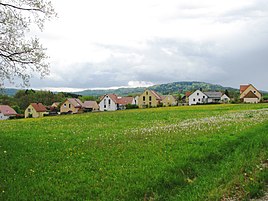
Kettenbach (mountain near Neumarkt in the Upper Palatinate)
|
Kettenbach
Municipality
Coordinates: 49 ° 20 ′ 25 ″ N , 11 ° 25 ′ 11 ″ E
Berg bei Neumarkt in the Upper Palatinate |
|
|---|---|
| Height : | 420 m above sea level NHN |
| Residents : | 136 (December 31, 2015) |
| Postal code : | 92348 |
| Area code : | 09189 |
|
Kettenbach
|
|
Kettenbach is a part of the municipality Berg bei Neumarkt in the Upper Palatinate in the Upper Palatinate district of Neumarkt in the Upper Palatinate in Bavaria .
geography
The village is located in the Upper Palatinate Jura at about 420 m above sea level north-west of the municipality near the Ludwig-Danube-Main Canal .
history
Kettenbach is a founding of Ketter / Kettner / Kettenhofer, which were based in the imperial city of Nuremberg , in Neumarkt and in Berching ; Abbot Johann III, who died in 1603, comes from the Berching branch. Kettner of the Plankstetten Monastery . In 1459 Ulrich Schöner, a citizen of Neumarkt, had property in Kettenbach; he sold the mill to Ulrich Müllner. From 1542 to 1625, Kettenbach and the Electoral Palatinate were Protestant. When Prince Ottheinrich's landscape councilors sold various goods to the city of Neumarkt to repay state debts in 1546 , there was also a " fiefdom property " of Kettenbach. Towards the end of the Old Kingdom , around 1800, the village consisted of eleven farms and the community shepherd's house. There were three manors: the ecclesiastical slope administration Neumarkt, to which seven subjects (including the Mühlgut) belonged, the imperial city of Nuremberg with two subjects of the Heiliggeist-Spital and the St. Leonhard-Spital Lauf an der Pegnitz also with two subjects (Gimpl, Frieß) . The Haimburg Nursing Office exercised the jurisdiction over blood .
In the new Kingdom of Bavaria (1806), Kettenbach belonged to the Hausheim tax district , and when the community was formed around 1810/20, it also belonged to the Hausheim community with the town of Hausheim itself, with Rührersberg , Gspannberg , Haslach and (Klein-) Voggenhof . In 1836 the village consisted of 15 houses, a chapel and five "Brandy distilleries" as well as a mill with a grinder on the Kettenbach, a tributary of the Schwarzach .
Until 1930, the community of Hausheim and thus Kettenbach belonged to the Kastl district court , then to the Neumarkt district court . In the course of regional reform in Bavaria , Hausheim and its districts were incorporated into Berg in 1972.
Population development
- 1830: 97 (15 houses)
- 1871: 81 (31 buildings; 8 horses, 73 head of cattle)
- 1900: 69 (16 residential buildings)
- 1937: 80 (61 Catholics, 19 Protestants)
- 1950: 72 (15 residential buildings)
- 1970: 68
- 1987: 74 (20 residential buildings, 25 apartments)
- 2015-12-31: 136 (68 female, 68 male)
Transport links
Kettenbach can be reached via a municipal road that branches off from State Road 2240 and leads via Kettenbach to Grub and Ezelsdorf .
literature
- Repertory of the topographical atlas sheet. Neumarkt , 1836.
- Franz Xaver Buchner : The diocese of Eichstätt. Volume I, Eichstätt: Brönner & Däntler, 1937.
- Bernhard Heinloth: Historical Atlas of Bavaria. Part of Old Bavaria, issue 16: Neumarkt. Commission for Bavarian State History, Munich 1967.
Individual evidence
- ↑ Repertorium Atlasblatt Neumarkt, p. 87; Johann Nepomuk von Löwenthal: History of the mayor's office and the city of Neumarkt on the Nordgau or in today's Upper Palatinate , Munich: Zwingl'sche Schriften, 1805, p. 48
- ↑ Buchner I, p. 85
- ↑ Heinloth, p. 299
- ↑ Heinloth, p. 323
- ^ Repertory Atlasblatt Neumarkt, 1836, pp. 17 f., 49
- ^ Karl Friedrich Hohn: The rain district of the Kingdom of Bavaria, described geographically and statistically , Stuttgart and Tübingen: Cotta, 1830, p. 109
- ↑ Kgl. Statistical Bureau (ed.): Complete list of localities of the Kingdom of Bavaria. According to districts, administrative districts, court districts and municipalities, including parish, school and post office affiliation ... with an alphabetical general register containing the population according to the results of the census of December 1, 1875 . Adolf Ackermann, Munich 1877, 2nd section (population figures from 1871, cattle figures from 1873), Sp. 973 , urn : nbn: de: bvb: 12-bsb00052489-4 ( digitized ).
- ↑ Kgl. Statistical Bureau in Munich (edit): List of localities of the Kingdom of Bavaria ... [based on the results of the census of December 1, 1900] , Munich 1904, column 872
- ↑ Buchner I, p. 89
- ^ Official register of places for Bavaria, edited on the basis of the census of September 13, 1950 , Munich 1952, Col. 743
- ^ Official register of places for Bavaria. Territory: May 1, 1978. Munich 1978, p. 120
- ^ Official register of places for Bavaria, territorial status: May 25, 1987 , Munich 1991, p. 257
- ↑ Berg Bulletin , February 2016, p. 8
Web links
- Kettenbach in the location database of the Bavarian State Library Online . Bavarian State Library


