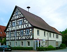
Untermünkheim
| coat of arms | Germany map | |
|---|---|---|

|
Coordinates: 49 ° 9 ' N , 9 ° 44' E |
|
| Basic data | ||
| State : | Baden-Württemberg | |
| Administrative region : | Stuttgart | |
| County : | Schwäbisch Hall | |
| Height : | 261 m above sea level NHN | |
| Area : | 27.14 km 2 | |
| Residents: | 3007 (December 31, 2018) | |
| Population density : | 111 inhabitants per km 2 | |
| Postal code : | 74547 | |
| Primaries : | 0791, 07906 , 07944 | |
| License plate : | SHA, BK , CR | |
| Community key : | 08 1 27 086 | |
| LOCODE : | DE UMH | |
| Address of the municipal administration: |
Hohenloher Strasse 33 74547 Untermünkheim |
|
| Website : | ||
| Mayor : | Christoph Maschke | |
| Location of the municipality of Untermünkheim in the Schwäbisch Hall district | ||
Untermünkheim is a municipality in the district of Schwäbisch Hall in the Franconian north-east of Baden-Württemberg .
geography
Geographical location
The eponymous main village Untermünkheim is located about five kilometers north of Schwäbisch Hall in the deeply cut valley of the Kocher on the so-called Kochereck, where the river bends northeast from its northern course. The coming of Hall, passing by a bridge, the village Federal Highway 19 climbs here in continuation of its North run by a steep walkways through the pages sword of Dobel- and Holy Bach the Hohenlohe plain . Obermünkheim is also located a little upstream in the Kocher valley at the inlet of the Schmiedbach , downstream are Haagen and Enslingen, which have merged with Untermünkheim. The majority of the municipality is located to the left of the river valley on the plateau, the largest places there are bereigshausen above the steep path, where the copper springs, copper and brachbach.
Neighboring communities
The community borders in the east on Braunsbach , in the south on the district town Schwäbisch Hall and in the north-west on Kupferzell in Hohenlohekreis .
Community structure
The municipality of Untermünkheim includes 15 villages, hamlets and farms.
- The village of Enslingen and the hamlets of Gaisdorf and Schönenberg as well as the abandoned villages of Bernsbach and Diepach belong to the former community of Enslingen .
- The former community of Nochigshausen includes the village of Übungsshausen and the hamlets of Brachbach, Kupfer, Leipoldsweiler and Steigenhaus as well as the abandoned town of Zittenheimat.
- The municipality of Untermünkheim in the territorial status as of December 31, 1971 includes the village of Untermünkheim, the hamlets of Haagen, Obermünkheim, Suhlburg and Wittighausen and the Eichelhof and Lindenhof farms, as well as the village of Breitenweidach, which has been removed.
Division of space

According to data from the State Statistical Office , as of 2014.
history
Untermünkheim was first mentioned in a document in 1216 as "Muncheim". In the 13th century, in what is now Enslingen, the noble family of the Lords of Enslingen can be traced , which died out in the male line in 1534.
In the 16th century castles, estates and estates became the property of the imperial city of Hall .
Beyond Untermünkheim lies the remains of the castle hill of the Untermünkheim moated castle at the river bridge , the rest of the Suhlburg near the Suhlburg district , Haagen castle existed until the 16th century.
In the course of the municipality reform in Baden-Württemberg, the formerly independent municipalities Enslingen and Nochigshausen were incorporated on January 1, 1972.
Religions
Evangelical
- Church of St. Kilian in Untermünkheim
- Evangelical Church Enslingen
- Church of St. Martin in bereigshausen
- South German Community Association Untermünkheim (Regional Church Community)
Catholic
- Catholic parish of St. Joseph
New Apostolic
- New Apostolic Church Enslingen
politics
Municipal council
The local council consists of twelve members (local election on May 25, 2014).
mayor
In May 2012, Christoph Maschke was re-elected with 57.2% of the vote.
coat of arms
A golden ship ending in two averted lion heads with a golden mast and an inclined golden oar on a blue background.
Economy and Infrastructure
traffic
The municipality has numerous bus lines with Schwäbisch Hall connected and is owned by the transport association KreisVerkehr Schwäbisch Hall to.
Culture and sights
Museums
The Rößler Museum mainly shows classic rural dowry furniture such as cupboards, chests and four-poster beds.
Buildings
- Geyersburg castle ruins
- Senftenschlössle
- Remains of the former Brickworks Zusatzshausen (drying halls)
- Remains of the former Haller Landheeg in Überhäuhölzle northwest and in Eichhölzle north of Brachbach; West of the hamlet used to be the Brachbacher Landturm, one of the few large inlets into the Landheeg, close to a triangle of streets, of which at least nothing has been preserved above ground.
Personalities
The well-known carpenter family Rößler comes from Untermünkheim. Johann Heinrich Rößler (1751–1832) founded a carpenter's workshop there, which his son Johann Michael Rößler (1791–1849) continued from 1818 on. The other two sons born in Untermünkheim, Johann Georg Rößler (1785–1844) and Johann Friedrich Rößler (1796–1863), founded their own workshops in other places. The painted farmer's furniture from the Rößler workshops are typical of Hohenlohe and the surrounding area of Hall.
References and comments
- ↑ State Statistical Office Baden-Württemberg - Population by nationality and gender on December 31, 2018 (CSV file) ( help on this ).
- ↑ A Gewann, which is known as Züttenheimat on a map today and as Sittenheimat on an older one , is located on the southern edge of the rest of the houses in the subdivision a little east of the Kupfermoors on the outflowing Kupfermoorbach. ⊙
- ^ The state of Baden-Württemberg. Official description by district and municipality. Volume IV: Stuttgart district, Franconian and East Württemberg regional associations. Kohlhammer, Stuttgart 1980, ISBN 3-17-005708-1 . Pp. 418-421
- ↑ State Statistical Office, area since 1988 according to actual use for Untermünkheim.
- ^ Federal Statistical Office (ed.): Historical municipality directory for the Federal Republic of Germany. Name, border and key number changes in municipalities, counties and administrative districts from May 27, 1970 to December 31, 1982 . W. Kohlhammer, Stuttgart / Mainz 1983, ISBN 3-17-003263-1 , p. 456 .
- ↑ http://www.swp.de/crailsheim/lokales/landkreis_schwaebisch_hall/maschke-bleibt-buergermeister-in-untermuenkheim-8470576.html
literature
- Topographic map 1: 25,000 Baden-Württemberg, as single sheet No. 6824 Schwäbisch Hall
Web links
- Map of the community of Untermünkheim on: State Agency for the Environment Baden-Württemberg (LUBW) ( information )
- Map of the municipality of Untermünkheim on: Geoportal Baden-Württemberg ( information )
- Measuring table sheet 6824 Hall from 1930 in the Deutsche Fotothek


