
Linz-Land district
| location | |
|---|---|
  |
|
| Basic data | |
| state | Upper Austria |
| NUTS III region | AT-312 |
| Administrative headquarters | Linz |
| surface | 460 km² |
| Residents | 151,371 (January 1, 2020) |
| Population density | 329 inhabitants / km² |
| License Plate | LL |
| District Commission | |
| District Captain | Manfred Hageneder |
| website | www.bh-linz-land.gv.at |
| map | |
  |
|

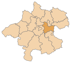
The Linz-Land district is a political district in the state of Upper Austria . It covers the southern foreland of Linz .
The district is the largest district in Upper Austria in terms of population.
history
The district was created in 1868 and included the area around Linz. In 1903 the judicial districts of Urfahr and Ottensheim were ceded to the newly established district of Urfahr . The judicial district of Neuhofen an der Krems from BH Steyr-Land was added as a replacement . Between 1939 and 1945 the two judicial districts of Urfahr and Ottensheim were again administered by Linz-Land. Until the end of 2004, the Linz-Land district was divided into the three judicial districts Linz-Land , Enns and Neuhofen an der Krems . After the dissolution of Neuhofen and the renaming of the Linz-Land judicial district, only the Traun and Enns judicial districts have existed since 2005 .
Administrative division
The Linz-Land district is divided into 22 communities , four of which are cities and seven are market communities. The population figures are from January 1st, 2020.

|
| local community | location | Ew | km² | Ew / km² | Judicial district | region | Type
|
photo | Metadata |
|---|---|---|---|---|---|---|---|---|---|
Allhaming
|

|
1,175 | 14.23 | 83 | Traun | local community
|

|
Acc. To code: 41001 |
|
Ansfelden
|

|
17.092 | 31.33 | 546 | Traun | urban community
|

|
Acc. To code: 41002 |
|
Branches
|

|
6,718 | 8.48 | 792 | Steyr | market community
|

|
According to code: 41003 |
|
Eggendorf in the Traunkreis
|

|
1,041 | 9.36 | 111 | Traun | local community
|

|
According to code: 41004 |
|
Enns
|

|
11,940 | 33.04 | 361 | Steyr | urban community
|

|
According to code: 41005 |
|
Hargelsberg
|

|
1,401 | 17.88 | 78 | Steyr | local community
|

|
According to code: 41006 |
|
Hofkirchen in the Traunkreis
|

|
1,948 | 13.9 | 140 | Steyr | local community
|

|
Acc. To code: 41008 |
|
Hörsching
|

|
6,209 | 19.99 | 311 | Traun | market community
|

|
Acc. To code: 41007 |
|
Kematen on the Krems
|

|
2,909 | 21.52 | 135 | Traun | local community
|

|
According to code: 41009 |
|
Kirchberg-Thening
|

|
2,435 | 15.89 | 153 | Traun | local community
|

|
According to code: 41010 |
|
Kronstorf
|

|
3,552 | 21.31 | 167 | Steyr | market community
|

|
According to code: 41011 |
|
Leonding
|

|
28,929 | 24.03 | 1204 | Traun | urban community
|

|
According to code: 41012 |
|
Neuhofen an der Krems
|

|
6,637 | 17.96 | 370 | Traun | market community
|

|
According to code: 41014 |
|
Niederneukirchen
|

|
2,108 | 20.78 | 101 | Steyr | local community
|

|
According to code: 41015 |
|
Oftering
|

|
2.110 | 13.5 | 156 | Traun | local community
|

|
According to code: 41016 |
|
Pasching
|

|
7,629 | 12.47 | 612 | Traun | local community
|

|
According to code: 41017 |
|
Piberbach
|

|
1,875 | 17.29 | 108 | Traun | local community
|

|
According to code: 41018 |
|
Pucking
|

|
3,979 | 19.68 | 202 | Traun | market community
|

|
According to code: 41019 |
|
St. Florian
|

|
6.181 | 44.12 | 140 | Steyr | market community
|

|
According to code: 41013 |
|
St. Mary
|

|
4,828 | 37.59 | 128 | Traun | local community
|

|
According to code: 41020 |
|
Traun
|

|
24,756 | 15.49 | 1598 | Traun | urban community
|

|
According to code: 41021 |
|
Wilhering
|

|
5,919 | 29.99 | 197 | Traun | market community
|

|
According to code: 41022 |
Focus
The main area of the Linz-Land district is in the Nettingsdorf cadastral community , Ansfelden ( ⊙ ).
Population development

Web links
Individual evidence
- ↑ Statistics Austria - Population at the beginning of 2002–2020 by municipalities (area status 01/01/2020)
- ↑ center point
Statutory cities: Linz | Steyr | catfish
Political districts: Braunau am Inn | Eferding | Free City | Gmunden | Grieskirchen | Kirchdorf | Linz-Land | Perg | Ried im Innkreis | Rohrbach | Schärding | Steyr-Land | Urfahr environment | Vöcklabruck | Catfish Land
Coordinates: 48 ° 12 ' N , 14 ° 18' E