Maidstone (Vermont)
| Maidstone | ||
|---|---|---|
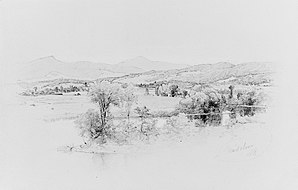
 Maidstone, Vermont by Albert Fitch Bellows |
||
| Location in Vermont | ||
|
|
||
| Basic data | ||
| Foundation : | October 12, 1761 | |
| State : | United States | |
| State : | Vermont | |
| County : | Essex County | |
| Coordinates : | 44 ° 38 ′ N , 71 ° 38 ′ W | |
| Time zone : | Eastern ( UTC − 5 / −4 ) | |
| Residents : | 208 (as of 2010) | |
| Population density : | 2.6 inhabitants per km 2 | |
| Area : | 83.6 km 2 (approx. 32 mi 2 ) of which 79.1 km 2 (approx. 31 mi 2 ) are land |
|
| Height : | 421 m | |
| Postal code : | 05905 | |
| Area code : | +1 802 | |
| FIPS : | 50-42475 | |
| GNIS ID : | 1462141 | |
| Website : | maidstone-vt.org | |
Maidstone is a town in Essex County in the US state of Vermont . At the last census in 2010 it had a total of 208 inhabitants. It is part of the Berlin Micropolitan Statistical Area .
geography
Geographical location
Maidstone is centrally located in east Essex County. The Connecticut River forms the eastern border with New Hampshire , several smaller tributaries of the Connecticut River drain the area of the town and the Paul Stream runs through the north in an easterly direction . Maidstone Lake is centrally located in the area of the town . The surface is hilly and the highest point is the east of Maidstone Lake located 628 m high Stoneham Mountain .
Neighboring communities
All distances are given as straight lines between the official coordinates of the places from the 2010 census.
- North: Brunswick , 3 miles
- Northeast: Stratford , New Hampshire, 8.4 mi
- East: Lancaster , 7.5 miles
- South: Guildhall , 2.9 mi
- Southwest: Granby , 7.5 mi
- Northwest: Ferdinand , 16.9 km
climate
The mean mean temperature in Maidstone ranges from −11.7 ° C (11 ° Fahrenheit ) in January to 18.3 ° C (65 ° Fahrenheit) in July. This means that the place is around 9 degrees cooler than the long-term average in the USA. The snowfall between mid-October and mid-May is more than two meters, about twice as high as the average snow depth in the USA. The daily sunshine duration is at the lower end of the range of values in the USA, between September and mid-December it is even significantly lower.
history
The Grant for Maidstone was awarded on October 12, 1761 by Benning Wentworth as part of the New Hampshire Grants . The Grant covered 17,472 acres (7,071 hectares ).
It was one of several grants that a group of land investors led by Samuel Averill from Connecticut won. In addition to Maidstone, they also received grants for Averill, Ferdinand, Lewis and other towns. It is believed that Maidstone was named after Maidstone in Kent . This is where many of Connecticut's early settlers came from.
The town organized itself in 1788, the first town clerk was Haines French.
Maidstone was on the North Stratford Railroad . However, it is now out of service.
Population development
| Census Results - Town of Maidstone, Vermont | ||||||||||
|---|---|---|---|---|---|---|---|---|---|---|
| year | 1700 | 1710 | 1720 | 1730 | 1740 | 1750 | 1760 | 1770 | 1780 | 1790 |
| Residents | 125 | |||||||||
| year | 1800 | 1810 | 1820 | 1830 | 1840 | 1850 | 1860 | 1870 | 1880 | 1890 |
| Residents | 152 | 177 | 166 | 236 | 271 | 237 | 259 | 254 | 286 | 198 |
| year | 1900 | 1910 | 1920 | 1930 | 1940 | 1950 | 1960 | 1970 | 1980 | 1990 |
| Residents | 206 | 175 | 171 | 123 | 96 | 81 | 78 | 94 | 100 | 131 |
| year | 2000 | 2010 | 2020 | 2030 | 2040 | 2050 | 2060 | 2070 | 2080 | 2090 |
| Residents | 105 | 208 | ||||||||
Culture and sights
Parks
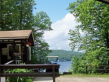
The Maidstone State Park is located on Maidstone Lake . It was created in 1938 by the Civilian Conservation Corps (CCC). The Maidstone Lake is a glacial lake, which was formed about 12,000 years ago. It is up to 120 feet (36.6 m ) deep. Today a popular destination for camping, hiking and fishing.
Economy and Infrastructure
traffic
The Vermont State Route 102 runs north to south from Guildhall in the south to Brunswick in the north, parallel to the Connecticut River through the eastern part of the Town. The historic Janice Peaslee Bridge , built in 1893, formerly Maidstone-Stratford Hollow Bridge , connects Maidstone with Stratford Hollow. After it was closed for disrepair in 1990, MP Janice Peaslee campaigned for the restoration. When it opened in 2005, the bridge was renamed in her honor.
Public facilities
The Northeastern Vermont Regional Hospital in St. Johnsbury is the closest hospital for residents of the Town.
education
Maidstone is part of the Essex-Caledonia Supervisory Union with Concord, Granby, Guildhall, Kirby, Lunenburg, Victory and Waterford . There is no school of its own in Maidstone.
There is no library of its own in Maidstone. The closest are in Guildhall or Strafford, New Hampshire.
literature
- Zadock Thompson: History of Vermont, natural, civil and statistical, in three parts . Chauncey Goodrich, Burlington 1842, p. Volume III p 108 ( limited preview in Google Book search). (for the period up to 1840)
- Benjamin Homer Hall: History of Eastern Vermont . D. Appleton & Co., New York 1865 ( limited preview in Google Book search).
Web links
- Homepage of the municipality (English)
- Profile of the community on the official portal www.Vermont.gov (English)
- Entry at VirtualVermont.com (English) ( Memento from May 13, 2016 in the Internet Archive )
Individual evidence
- ↑ Maidstone in the United States Geological Survey's Geographic Names Information System , accessed May 28, 2017
- ↑ Population data from the 2010 US Census in the American Factfinder
- ↑ Stoneham Mountain on Peakery.com , accessed May 28, 2017
- ↑ Index of / geo. In: census.gov. Retrieved May 18, 2019 .
- ↑ Maidstone on the City Daty portal , accessed May 28, 2017
- ^ Zadock Thompson: History of Vermont, Natural, Civil, and Statistical , page 108 , accessed May 27, 2017
- ↑ Maidstone on Virtual Vermont , accessed May 28, 2017
- ↑ Maidstone Town Plan 2007, History, page 11 (pdf) , accessed May 28, 2017
- ↑ Population 1790–2010 according to the census results
- ^ Maidstone State Park , accessed May 28, 2017
- ↑ Essex-Caledonia Supervisory Union ( page no longer available , search in web archives ) Info: The link was automatically marked as defective. Please check the link according to the instructions and then remove this notice. , accessed on May 28, 2017


