
Lai da Marmorera
| Lai da Marmorera | |||||||||
|---|---|---|---|---|---|---|---|---|---|
 |
|||||||||
|
|||||||||
|
|||||||||
| Coordinates | 768 733 / 152187 | ||||||||
| Data on the structure | |||||||||
| Lock type: | Earthfill dam | ||||||||
| Construction time: | 1950-1954 | ||||||||
| Height of the barrier structure : | 91 m | ||||||||
| Height above the river bed : | 65 m | ||||||||
| Height of the structure crown: | 1684 m above sea level M. | ||||||||
| Building volume: | 2 700 000 m³ | ||||||||
| Crown length: | 400 m | ||||||||
| Crown width: | 12 m | ||||||||
| Base width: | approx. 400 m | ||||||||
| Slope slope on the air side : | approx. 1: 2 | ||||||||
| Slope slope on the water side : | approx. 1: 2.5 | ||||||||
| Power plant output: | 3 stages: 1st stage: Tinizong 69 MW 2nd stage: Tiefencastel Ost 52 MW 3rd stage: Sils 26 MW Rothenbrunnen 38 MW Total: 185 MW |
||||||||
| Operator: | Electricity company of the city of Zurich | ||||||||
| Data on the reservoir | |||||||||
| Altitude (at congestion destination ) | 1680 m above sea level M. | ||||||||
| Water surface | 1.41 km² | ||||||||
| Reservoir length | 2.6 km | ||||||||
| Storage space | 60 million m³ | ||||||||
| Total storage space : | 62.6 million m³ | ||||||||
| Catchment area | 89 km² | ||||||||
| Design flood : | 200 m³ / s | ||||||||
 |
|||||||||

The Lai da Marmorera is a Swiss artificial lake in the canton of Grisons in the municipality Surses that the Mittelbünden power plants of the power station of the city of Zurich is operated (EWZ). It can be reached from Tiefencastel or from the Engadin from the village of Silvaplana over the Julier Pass . The only village on the lake is Marmorera . Above the western end of the dam are the ruins of Marmels Castle .
history

The Marmorera Dam (Castiletto) was completed in 1954. The old Marmorera was flooded after the main buildings were blown up. The new Marmorera was built above the reservoir and the Julier Pass road. Many residents preferred to move away for economic and emotional reasons.
Diving
The Lai da Marmorera is often visited by divers in summer and autumn, as it offers ideal conditions for mountain lake diving : crystal clear water, remains of the sunken village and an approach that does not lead over any passes from the north. There are two safe and easily accessible dive sites : the first below the “Marmorera Dorf” post bus stop and the second near the Julier Bridge at the southern end of the lake.

Emptied reservoir in April 2010
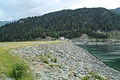
Marmorera earthfill dam (Castiletto)

Divers in Lai da Marmorera

Aerial photo (1954)


See also
Individual evidence
- ↑ a b c d Lakes in Switzerland: Natural and storage lakes, Federal Office for the Environment FOEN, 2007 ( Memento from October 5, 2008 in the Internet Archive ) → Lakes in Switzerland (PDF)
- ↑ Claudia and Norbert Eisenlohr, Dive Guide - Tauchplatzführer der Schweiz , 3rd edition, 2005 Claudia and Norbert Eisenlohr, ISBN 3-9521233-1-5
literature
- Paul J. Mark: A mountain village is going under. Terra Grischuna-Verlag, Chur 2005
- Andreas Siegfried: Marmorera . ( swissdams.ch [PDF]).
Web links
- Lai da Marmorera on schweizersee.ch
- History of Marmorera (with photos of the old village)
- Swisstopo, time travel through maps from 1854 to today with the location of the flooded village
Swiss reservoirs with a content of over 10 million m³:
Albignasee |
Arnensee |
Lac de Barberine |
Lago Bianco |
Lac Brenet |
Lago dei Cavagnöö |
Lac de Cleuson |
Lai da Curnera |
Davosersee |
Lac des Dix |
Lac d'Emosson |
Engstlensee |
Gelmersee |
Gigerwaldsee |
Göscheneralpsee |
Lake Gruyère |
Griessee |
Grimselsee |
Lac de l'Hongrin |
Klingnau Reservoir |
Klöntalersee |
Lake Lei |
Limmerensee |
Lake Livigno |
Lake Lucendro |
Lungerersee |
Lake Luzzone |
Lai da Marmorera |
Mattmarksee |
Lac de Mauvoisin |
Lac de Moiry |
Lac de Montsalvens |
Lac de Moron |
Muttsee |
Lai da Nalps |
Lake Naret |
Oberaarsee |
Lac de Pérolles |
Lake Poschiavo |
Raeterichsbodensee |
Lake Ritóm |
Lac de Salanfe |
Lago del Sambuco |
Schiffenensee |
Sihlsee |
Lai da Sontga Maria |
Sufnersee |
Lac des Toules |
Lake Tremorgio |
Lac de Tseuzier |
Lac du Vieux Emosson |
Lake Vogorno |
Wägitalersee |
Wohlensee |
Zervreila Lake