
Namborn
| coat of arms | Germany map | |
|---|---|---|

|
Coordinates: 49 ° 31 ' N , 7 ° 8' E |
|
| Basic data | ||
| State : | Saarland | |
| County : | St. Wendel | |
| Height : | 348 m above sea level NHN | |
| Area : | 26 km 2 | |
| Residents: | 7002 (Dec. 31, 2019) | |
| Population density : | 269 inhabitants per km 2 | |
| Postal code : | 66640 | |
| Primaries : | 06857 (districts Namborn and Heisterberg: 06854, district Baltersweiler: 06851) | |
| License plate : | WND | |
| Community key : | 10 0 46 113 | |
| Community structure: | 10 districts; 8 municipal districts | |
| Address of the municipal administration: |
Schlossstrasse 13 66640 Namborn |
|
| Website : | ||
| Mayor : | Sascha Hilpüsch ( SPD ) | |
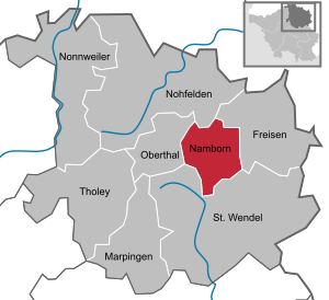
| Location of the municipality of Namborn in the St. Wendel district | ||
  |
||

Namborn is a Saarland municipality in the center of the St. Wendel district and is located about 40 km northeast of Saarbrücken on the B 41 and the Saarbrücken – Bingen / Mainz railway line . The most famous landmark of the community is the ruins of the Liebenburg on the Schloßberg in the Eisweiler district.
The administrative headquarters are in the Hofeld-Mauschbach district because of the convenient transport links and the central location. The distance to the Bostalsee is approx. 10 km and to the district town of St. Wendel approx. 7 km.
geography
location
Namborn is located in a wooded low mountain range between the Nahe and Blies rivers in the Saar-Hunsrück Nature Park . The highest point is the Friedenberg (Hirstein) with 509 m; the deepest point is 298 m where the Todbach leaves the municipality to St. Wendel (Urweiler). Recognized natural monuments can be found in Baltersweiler (Wendalinushöhle) , in Furschweiler (linden tree) , in Namborn (Allerbach rock face) and in Roschberg (3 oaks).
Community structure
The municipality of Namborn comprises the following ten districts: Baltersweiler , Eisweiler , Furschweiler , Gehweiler , Heisterberg , Hirstein , Hofeld-Mauschbach , Namborn , Pinsweiler and Roschberg .
natural reserve
An approximately 10-hectare Schlossberg area in the Eisweiler district has been protected as a nature reserve since February 1937 and November 1957 due to the occurrence of several rare plant species , making it the oldest nature reserve in Saarland. Since November 1983, the Weiherbruch and Rohrbachwiesen area in the Namborn district, together with the neighboring municipality of Oberthal, has been a second nature reserve with a size of 19.68 hectares.
Parts of the Heisterberg, Hirstein, Hofeld-Mauschbach, Namborn and Pinsweiler districts also belong to the landscape protection area of the district of St. Wendel. The entire municipality is located in the Saar-Hunsrück Nature Park.
The ordinance establishing the floodplain at Todbach and the “Rohrbacher Wiesen” water protection area ordinance protect other areas.
The nature reserve "Grauer Dorn bei Baltersweiler" - L 6508-304 - with a size of 6.36 ha has also existed since October 2016. The reserve is located in the municipality of Namborn, there in the districts of Baltersweiler and Hofeld-Mauschbach and the city of St . Wendel, in the district of Bliesen. In addition to the overview map contained in the aforementioned regulation, there is also a "Detailed map L 6508-304 - Grauer Dorn bei Baltersweiler".
history
Numerous archaeological finds from the Celtic and Roman times, which were discovered or partially exposed in the towns of Baltersweiler , Eisweiler , Furschweiler , Bornerhof , Heisterberg , Hirstein , Namborn and Roschberg , attest to early settlement of the municipality. The Liebenburg on the Schloßberg (Eisweiler), first mentioned in a document in 1220 and probably built around 1200, is further proof of the importance of the area.
From the early Middle Ages (around 1300) to July 1, 1952, the historical development of the ten districts has in some cases been different. The eight places Baltersweiler , Eisweiler , Furschweiler , Gehweiler (partially), Heisterberg , Hofeld-Mauschbach , Pinsweiler and Roschberg belonged to the St. Wendel office or temporarily and partially to the Liebenberg (Liebenburg) office in the Electorate of Trier until 1794.
Hirstein initially belonged to the County of Veldenz, which passed to Pfalz-Zweibrücken by way of succession in the 15th century. Likewise, the part of Gehweiler above the Eichertsbach.
Namborn , however, belonged to the office of Schaumburg in the Duchy of Lorraine, which fell to the Kingdom of France in 1766. With a contract dated November 15, 1786, this office was transferred to Pfalz-Zweibrücken in exchange. The actual transition took place in March 1787.
Due to the French Revolution and the subsequent occupation of the entire left bank of the Rhine in 1794, the Electorate of Trier and the Duchy of Pfalz-Zweibrücken perished. New administrative divisions were made under French rule. The ten districts of the municipality of Namborn were assigned to the following Mairien (mayor's offices):
a) Mairie Walhausen = Baltersweiler , Eisweiler , Furschweiler , Gehweiler , Heisterberg , Hirstein , Hofeld-Mauschbach and Pinsweiler as well as Asweiler, Eitzweiler, Gonnesweiler, Mosberg-Richweiler, Steinberg -ckenhardt and Walhausen
b) Mairie Oberkirchen = Roschberg as well as Grügelborn, Haupersweiler, Oberkirchen, Reitscheid and Leitersweiler
c) Mairie Namborn = own Mairie in the Moselle department
The merger of the Moselle department with France took place on February 14, 1793; the association of the Saar department, to which u. a. the Mairien Walhausen and Oberkirchen belonged, took place on February 9, 1801 with the conclusion of the final peace treaty. With this treaty, France was given the entire area on the left bank of the Rhine.
After Napoleon's defeat in the Battle of Leipzig in October 1813, France was referred back to its former borders on January 1, 1792 by a peace treaty of May 30, 1814. At the same time, the Congress of Vienna (September 18, 1814 to June 9, 1815) began a reorganization of the territories. In Articles 49 and 50 of the Vienna Final Act, the Kingdom of Prussia was obliged to use certain parts of the preserved areas and a. to cede to the Duchy of Saxony-Coburg and the Duchy of Oldenburg. In an interim solution, "Mairie Walhausen" and "Mairie Oberkirchen" became mayor's office of Walhausen or mayor's office of Oberkirchen without changing the affiliation of the individual communities. Namborn was assigned to the Tholey mayor. The release of the above-mentioned areas to the Duchy of Saxony-Coburg Oldenburg was issued with the Royal Prussian Release Patent of September 9, 1816. With the Ducal Saxony-Coburg ownership patent dated September 11, 1816, nine places (except Hirstein) in today's municipality became part of the Duchy of Saxony-Coburg. With the handover / takeover protocol of April 9, 1817 in Frankfurt, the Royal Prussian dismissal patent from the same day and the patent for the possession of the Principality of Birkenfeld from April 16, 1817, the village of Hirstein became part of the Duchy of Oldenburg.
With the formation of three cantons (St. Wendel, Baumholder and Grumbach) and 15 mayorships under Saxe-Coburg by ordinance of January 11, 1817, u. a. for the first time the mayor's office Namborn, which included the following places: Namborn, Baltersweiler, Eisweiler, Furschweiler and Born (Bornerhof), Gehweiler, Heisterberg, Hofeld and Mauschbach as well as Pinsweiler. Roschberg came to the mayor's office in Oberkirchen. According to the ordinance of March 6, 1819, Saxony-Coburg named the area it took possession of on September 11, 1816 as the Principality of Lichtenberg (seat in St. Wendel). As part of the expansion with only seven mayor's offices according to the ordinance of September 22, 1823, on October 1, 1823 u. a. the mayor offices of Namborn and Oberkirchen were also dissolved. In the canton of St. Wendel, only two mayor's offices were created for this, namely the mayor's office of St. Wendel, to which Roschberg now belonged (along with 16 other places) and the mayor's office of Bliesen with the places Bliesen, Oberthal, Güdesweiler, Gronig, Namborn, Eisweiler, Gehweiler, Heisterberg, Pinsweiler, Hofeld and Mauschbach, Baltersweiler, Furschweiler and Bornerhof , Alsweiler, Winterbach and Marpingen.
By state treaty of May 31, 1834, the Duchy of Saxony-Coburg ceded the Principality of Lichtenberg to the Kingdom of Prussia, which took possession of it through the Royal Prussian Occupation Patent of August 15, 1834. By order of March 25, 1835, it was determined that on April 1, 1835 the previous Principality of Lichtenberg would be incorporated into the Trier administrative district of the Rhine Province and will now be run as the St. Wendel district. Under Prussian rule, on January 1, 1836, the mayor offices of the canton of St. Wendel were reorganized into the three mayor offices of St. Wendel, Alsweiler and Oberkirchen. According to the decree of September 23, 1836, the following 17 places belonged to the mayor's office of Oberkirchen: Alsfassen and Breiten (until 1843), Baltersweiler, Eisweiler, Furschweiler, Gehweiler , Grügelborn, Haupersweiler and Seitzweiler, Heisterberg, Hofeld , Leitersweiler, Mauschbach, Namborn , Oberkirchen, Pinsweiler , Reitscheid, Roschberg and Urweiler. The place name "Hofeld-Mauschbach" has been used in some cases since the middle of the 19th century, but it was only found in the civil status registers from October 16, 1947 onwards.
The peace treaty of June 28, 1919, which came into force on January 10, 1920, had administrative separation at the district level (St. Wendel-Süd and St. Wendel-Nord district) and at the mayoral level (Oberkirchen-Süd and Oberkirchen-Nord) Consequence (Saar area border). The final administrative separation at the district level took place on March 23, 1920 with the formation of the "Stammkreis" St. Wendel (St. Wendel-Süd in the Saar area) and the "Remainderkreis" St. Wendel-Baumholder (St. Wendel-Nord in the Rhine Province) . When the administration of Oberkirchen's mayor's offices in Oberkirchen-Süd and Oberkirchen-Nord was separated on May 7, 1920, Gehweiler and Roschberg joined Oberkirchen-Nord along with Oberkirchen, Reitscheid, Grügelborn, Leitersweiler and Haupersweiler. On January 1, 1921, Roschberg was again assigned to Oberkirchen-Süd, so that it now included the towns of Baltersweiler, Eisweiler, Furschweiler, Heisterberg, Hofeld-Mauschbach, Namborn, Pinsweiler, Roschberg and Urweiler. With the decree of the government commission of the Saar area of May 7th, 1921, the name mayor's office Oberkirchen-Süd was changed to mayor's office Namborn (based in St. Wendel). The introduction of the Prussian official order in Saarland (from March 1, 1935, the Saarland was reorganized) by ordinance of July 31, 1935, changed the name of Mayor's Office Namborn to Amt Namborn on August 1, 1935. On April 1, 1937, the Oldenburg region of Birkenfeld (1817 to 1918 Principality of Birkenfeld) was transferred to the State of Prussia and from that point on formed the Birkenfeld district with the rest of the St. Wendel-Baumholder district. Hirstein thus belonged to approx. 120 years to the principality / regional part of Birkenfeld (Oldenburg) in the mayor's office or the Nohfelden office. Gehweiler (from 1920 Oberkirchen-Nord) first came to the mayor's office in Oberkirchen (seat in Oberkirchen) or Amt Oberkirchen, which on April 1, 1939 was merged with the Amt Burglichtenberg to form the new Amt Freisen, based in Berschweiler (since summer 1944 in Freisen) . The civil status books were kept from April 1, 1939 to July 31, 1946 at the registry office in Berschweiler, now Baumholder.
From 1943, due to the war, the three offices of Alsweiler, St. Wendel-Land and Namborn (all based in St. Wendel) were administered jointly. In March 1945, Heisterberg lost its independence by order of the American military government and was slammed into Namborn. The joint administration of the three offices was abolished on April 1, 1945 through the separation of the Alsweiler office and was limited to the Namborn office and the St. Wendel-Land office. By order of May 6, 1946, Heisterberg was declared an independent municipality again with effect from May 14, 1946. On July 20, 1946, the communities of Gehweiler , Grügelborn, Leitersweiler and Reitscheid , which had previously belonged to the district of Birkenfeld, were incorporated into the office of Namborn and Hirstein to the office of Türkismühle and thus belonged to the Saarland for the first time. By order of February 26, 1947, the name Amt Namborn was replaced by the name Administrative District Namborn. With effect from May 1, 1947, Hirstein was assigned to the Namborn administrative district by the Türkismühle administrative district. At this time, the joint administration of the two offices (administrative districts) Namborn and St. Wendel-Land in connection with the merger of the offices (administrative districts) Alsweiler and St. Wendel-Land to form the new office (administrative district) St. Wendel-Land ended . At the same time, Baltersweiler , Haupersweiler, Leitersweiler and Urweiler were spun off from the Namborn administrative district and incorporated into the new St. Wendel-Land administrative district. The separation of the two offices (administrative districts) was followed from May 8, 1947 to October 20, 1950, with a temporary relocation of the administrative headquarters of the administrative district of Namborn to Namborn, Heisterberger Strasse (Gasthaus Sesterheim) with subsequent return to St. Wendel, Julius Bettingen-Str. 5. With effect from September 1, 1951, the municipal code of July 10, 1951 changed the designation administrative districts back into offices (Amt Namborn). With effect from July 1, 1952, the municipalities of Baltersweiler , Haupersweiler, Leitersweiler, Oberkirchen, Schwarzerden and Urweiler were spun off from the St. Wendel-Land office and incorporated into the Namborn office. At the same time the name was changed from Amt Namborn to Amt Oberkirchen-Namborn. The following 17 communities belonged to the Oberkirchen-Namborn office: Baltersweiler, Eisweiler, Furschweiler, Gehweiler , Grügelborn, Haupersweiler, Heisterberg, Hirstein, Hofeld-Mauschbach , Leitersweiler, Namborn , Oberkirchen, Pinsweiler , Reitscheid, Roschberg , Schwarzerden and Urweiler.
Through the law for the preparation of the communal territorial and administrative reform in Saarland of December 17, 1970 with § 2 para. 3 sentence 1 “When the communes are reorganized, unit congregations are to be formed”, the dissolution of the independent communes and offices that have existed for centuries in guided the way. With the reorganization law of December 19, 1973, the previously independent municipalities were finally merged into unitary municipalities on January 1, 1974 and the previous offices were dissolved. The new municipality of Namborn with the ten districts (municipality parts) Baltersweiler, Eisweiler, Furschweiler, Gehweiler, Heisterberg, Hirstein, Hofeld-Mauschbach, Namborn, Pinsweiler and Roschberg was determined as the legal successor to the Oberkirchen-Namborn office . The remaining seven former communities of Leitersweiler and Urweiler were assigned to the city of St. Wendel and the communities of Grügelborn, Haupersweiler, Oberkirchen, Reitscheid and Schwarzerden to the municipality of Freisen. In mid-August 1975 the official business was relocated from St. Wendel to Julius Bettingen-Str. 5 to the town hall in the Hofeld-Mauschbach district, Schloßstr. 13, the new administrative center of the municipality of Namborn.
Districts
For all ten districts of the municipality of Namborn there are separate pages with their respective place names; at the district of Namborn with the addition "(place)".
- Baltersweiler ; First mentioned: 1304 Balterswilre
- Eisweiler ; First mentioned: 1335 Eynßwilre
-
Furschweiler
- First mentioned: 1469 Forswyler, 1328 Born (Bornerhof)
- Gehweiler ; First mentioned: 1325 Gewiller
-
Heisterberg
- First mentioned: 1360 Heysterberg
- Heisterberg is also popularly known as "the Wall".
- Hirstein ; First mentioned: 1397 Hirstein
-
Hofeld-Mauschbach
- First mentioned: 1278 Hoychfelde, 1303 Musbach - guided tour with the double name "Hofeld-Mauschbach" - see under History: Since around the middle of the 19th century [...]
- Namborn ; First mentioned: 1360 Nuimborn
- Pinsweiler ; First mentioned: 1335 Pontwilre
- Roschberg ; First mentioned: 1335 Roßbergh
Population development
Summary of the inhabitants of the former municipalities (see individual results for the 10 districts):
- 1787 = 650 inhabitants - St. Wendel Office (Electorate Trier) - only partially without Hirstein and Namborn, Hofeld and Gehweiler
- 1819 = 1540 inhabitants - Mayor Namborn, Roschberg in Mayor Oberkirchen (Principality of Lichtenberg / Duchy of Saxony-Coburg), Hirstein in the Principality of Birkenfeld (Duchy of Oldenburg)
- 1843 = 2174 inhabitants - Oberkirchen mayor (Rhine Province / Kingdom of Prussia), Hirstein in the Principality of Birkenfeld (Duchy of Oldenburg)
- May 17, 1939 = 5189 inhabitants - Namborn (Saarland), Hirstein in Nohfelden and Gehweiler in Freisen in Berschweiler (Prussia / Rhine Province) - 1939 census
- November 14, 1951 = 6011 inhabitants - Amt Namborn - 1951 census
- June 6, 1961 = 6914 inhabitants - Oberkirchen-Namborn district - 1961 census (1,323 residential buildings)
- May 27, 1970 = 7593 inhabitants - Oberkirchen-Namborn district - 1970 census
- December 31, 1973 = 7,433 inhabitants - Oberkirchen-Namborn district - regional and administrative reform on January 1, 1974
- May 25, 1987 = 7386 inhabitants - Namborn municipality - 1987 census
- May 9, 2011 = 7406 inhabitants - Namborn municipality - 2011 census (2547 residential buildings)
- Dec. 31, 2019 = update by the municipality: with main residence = 7071 inhabitants, with secondary residence in the municipality = 423 inhabitants
politics
Municipal council
The council with 27 seats is made after the local elections on 26 May 2019 with a turnout of 69.8% as follows:
| CDU | 41.5% | 11 seats |
| SPD | 22.6% | 6 seats |
| LEFT | 8.2% | 2 seats |
| Free list Namborn | 27.8% | 8 seats |
mayor
- January 1, 1974 to March 31, 1983: Reinhold Sartorius, CDU
- April 1, 1983 to March 31, 2001: Herbert Müller, SPD
- April 1, 2001 to November 30, 2018: Theo Staub, SPD
- December 1, 2018 to date: Sascha Hilpüsch, SPD
Parishes
Since February 15, 1974, the municipal area of Namborn has been divided into the following 8 municipal districts according to the KSVG: Baltersweiler, Eisweiler / Pinsweiler, Furschweiler, Gehweiler, Hirstein, Hofeld-Mauschbach, Namborn / Heisterberg and Roschberg. In principle, each part of the municipality forms its own municipality. However, the districts of Heisterberg and Pinsweiler each do not have the required statutory minimum population of 200 residents to form their own municipal districts. Therefore the districts Eisweiler and Pinsweiler form the common municipality Eisweiler / Pinsweiler and the districts Namborn and Heisterberg the common municipality Namborn / Heisterberg.
The term “community district” is a purely legal administrative term and merely represents the “spatial delimitation of the jurisdiction of the respective local council” (use therefore only in connection with a local council or local council activity; the name of the district has priority).
coat of arms
The municipality has had its coat of arms since 1976, on which a tinned golden tower with two black windows is depicted in red on a golden three-mountain, accompanied by a golden heraldic lily on each side . At the same time she was given the right to use the colors "red-yellow" as community colors.
The tower with the three battlements and two windows symbolizes the Liebenburg on the Schlossberg. A picture of a former official clerk from 1613 was used as a template for the presentation. The lilies were u. a. based on the coat of arms of the former Electorate of Trier town, now the district town of St. Wendel . The colors red and gold are those of the former Duchy of Lorraine , to which the district of Namborn belonged; The two colors can also be found in the coat of arms of the former Liebenburg lords.
Town twinning
A partnership has existed between Namborn and the French town of Langeac in the Haute-Loire department in the Auvergne-Rhône-Alpes region, around 800 km away, since 1987 .
Economy and Infrastructure
The eponymous district of Namborn has the most inhabitants and the district of Hirstein is the largest village in terms of area, but the center of public life is the district of Eisweiler, where, in addition to a four-part shopping center, the post office, the Liebenburghalle and the senior center “St. Laurentius ”.
schools
- Primary school Namborn - Marienschule (voluntary all-day school)
Kindergartens
In Namborn, Furschweiler and Hirstein there are day-care centers run by the municipality.
traffic
Namborn is on federal highway 41 . Coming from Nohfelden, this forms the Hirstein thoroughfare and then crosses the towns of Pinsweiler, Eisweiler, Hofeld-Mauschbach and Baltersweiler (in the direction of St. Wendel). The regional train on the Nahe Valley Railway connects the community or its three stations / stops Baltersweiler, Hofeld-Mauschbach and Namborn with places between Bingen / Mainz and Saarbrücken . The bus routes in the municipality have been operated by Saar-Mobil GmbH, Püttlingen (Saarländischer Verkehrsverbund), since January 1, 2016. The state roads L 132, L 133 and L 320 provide the connections to the neighboring town of St. Wendel and the neighboring communities of Freisen and Oberthal.
Sanitation
In 1980 the Saar Wastewater Association started construction of the approx. 18 km long main collector up to the planned sewage treatment plant in Baltersweiler. The Baltersweiler sewage treatment plant finally went into operation at the end of 1990. All districts of the municipality of Namborn except Heisterberg are connected to this sewage treatment plant with mechanical-biological treatment. Since the end of 2006, the wastewater from Heisterberg has been disposed of by a so-called mixed water-fed plant treatment plant (for 100 population equivalents).
power supply
The Gemeindewerke Namborn GmbH (GWN), a joint company of the municipality of Namborn and VSE or Energis GmbH Saarbrücken, was founded on August 13, 1991. The object of the company is the gas supply in the municipality, the provision of supply and disposal services as well as the implementation of the municipal energy concept.
In the districts of Baltersweiler, Eisweiler, Furschweiler, Hofeld-Mauschbach and Namborn there is the possibility of supplying natural gas. Since January 1st, 2003, the water supply has been in the hands of WVW Wasser- und Energieversorgung Kreis St. Wendel GmbH.
Culture and sights


- Village community rooms are available in all districts (except Pinsweiler).
- A popular destination for hikers is the ruins of the 12th century Liebenburg in the Eisweiler district. The observation tower , which was built in 1976/77 on the donjon foundations, is visible from afar, offers views over the community and the St. Wendel region and houses a wedding room for weddings.
- The premium hiking trail “Smugglers' Path” created in 2009 (rated 53 points) has a length of 12.8 km at an altitude of 310 to 480 m above sea level (altitude 436 m). A walking time of 4 to 4.5 hours should be planned for the medium difficulty level. Starting point: at the Schützenhaus in the Hofeld-Mauschbach district, Furschweilerstraße (with the recommended walking direction clockwise). For hiking groups there is also the possibility of a guided hike. Telephone registration in the Namborn town hall.
- The street of the sculptures , which leads from St. Wendel to the Bostalsee, touches the municipality near Baltersweiler.
- By the municipality was also down West Wall , however, from its plants in the municipality only at Hirstein and Gehweiler blasted bunkers or Hofeld-Mauschbach and Baltersweiler few remains in the form of humps lines are available.
The parish churches of the Assumption of Mary in Namborn and St. Willibrord in Baltersweiler are also worth seeing . A similar church to the Assumption of Mary is St. Markus in Braunshorn .
Personalities
Sons and daughters of the church
- Bernhard Cullmann, (December 4, 1903 - August 10, 1977), oriental painter and graphic artist
- Otwin Massing , (born May 3, 1934 - † August 5, 2019), political scientist and sociologist
- Heinrich Mühlthei (* 1937 Furschweiler), professor at the Johannes Gutenberg University in Mainz
- Thomas Kleist (* 1955 Gehweiler), director of the Saarland broadcasting company
Affiliated with Namborn
- Bernadette Mac-Nelly (1920–2002), painter, designer, stage and costume designer, lived in Baltersweiler from 1982 to 2002
- Rainer Grün (1950–2010), retired State Secretary in the Saarland Ministry for the Environment. D., lived in Furschweiler
literature
- Hans Kräber (Red.): In the St. Wendeler Land. Namborn municipality. Kreissparkasse St. Wendel (Ed.), St. Wendel 1977. (Local history reading material. Vol. 17)
- Günter Scholl: 650 years of Heisterberg - local chronicle (1360 - 2010). OCLC 699527459 . (including about 60 documents (1816–1974) of the St. Wendel parishes 1920–1946)
- Günter Scholl (author): Administrative divisions in the St. Wendel district 1835 - 1974 , Heimat- und Verkehrsverein Namborn eV (ed.), Namborn 2017 (including around 200 documents 1815-2016), ISBN 978-3-00-057902- 8th
Web links
- Namborn municipality
- Local chronicle of Heisterberg
- Literature about Namborn in the Saarland Bibliography
- Link catalog on the subject of Namborn at curlie.org (formerly DMOZ )
- Local and tourist association Namborn
Individual evidence
- ↑ Saarland.de - Official population figures as of December 31, 2019 (PDF; 20 kB) ( help ).
- ^ Ordinance on the nature reserve "Schlossberg bei Hofeld", St. Wendel district of February 16, 1937
- ^ Ordinance on the "Weiherbruch und Rohrbachwiesen" nature reserve of November 14, 1983
- ^ Ordinance on the designation of landscape protection areas in the St. Wendel district of August 12, 1976 and subsequent amendments
- ^ Ordinance on the Saar-Hunsrück Nature Park of March 1, 2007
- ↑ Ordinance on the determination of the floodplain at Todbach in the area of the municipality of Namborn and the district town of St. Wendel from November 5, 2001
- ↑ Ordinance on the establishment of a water protection area in the communities of Namborn and Oberthal (Water Protection Area Ordinance “Rohrbacher Wiesen”) of July 8, 2003
- ↑ Ordinance on the "Grauer Dorn bei Baltersweiler" landscape protection area of October 5, 2016
- ↑ Law No. 928 for the preparation of the communal territorial and administrative reform in Saarland (GVRG) of December 17, 1970, Saarland Official Gazette 1970, No. 40, page 949 - at www.amtsblatt.uni-saarland.de (Official Gazette 1945 until 1998 as PDF files; 398 kB)
- ↑ Act No. 986 on the reorganization of the municipalities and districts of Saarland (Neugliederungsgesetz - NGG) of December 19, 1973, Official Gazette of Saarland 1973, No. 48, page 852 (PDF; 499 kB)
- ^ Federal Statistical Office (ed.): Historical municipality directory for the Federal Republic of Germany. Name, border and key number changes in municipalities, counties and administrative districts from May 27, 1970 to December 31, 1982 . W. Kohlhammer, Stuttgart / Mainz 1983, ISBN 3-17-003263-1 , p. 809 .
- ↑ Source: Document representation in the local chronicle Heisterberg (approx. 60 documents), author; Günter Scholl; see also www.heisterberg-saar.de
- ^ Namborn, Eisweiler district
- ↑ Furschweiler
- ↑ Heisterberg (Saar)
- ↑ Pinsweiler
- ↑ Roschberg
- ↑ Explanations of the historical atlas of the Rhine Province - Volume II - by Dr. Wilhelm Fabricius 1898, p. 128
- ^ The administrative authorities in the Principality of Lichtenberg 1819 and other statistical information from Daniel Hinkelmann - Heimatbuch des Landkreis St. Wendel 1967/1968 XII. Edition, p. 124
- ↑ Description of the government district of Trier - Second Part, Georg Bärsch 1846
- ↑ Population figures of the Saarland 1800 - 1910 by Jürgen Karbach - Journal for the history of the Saar area 1986/87, page 186 or 248 (20 years)
- ↑ Individual publications on Saarland statistics No. 35 - Official municipality register, 11th edition as of May 27, 1970 (census) and December 31, 1971 with an administrative map (with censuses 1939-1970) - Saarland Statistical Office 1972
- ↑ Individual publications on Saarland Statistics No. 24 - Municipal Statistics 1960/61, Part 2: Buildings and Apartments - Results of the building count on June 6, 1961 - Saarland Statistical Office 1964
- ↑ Statistical reports of the Saarland Statistical Office - population on December 31, 1973 (old territorial status) and on January 1, 1974 (new territorial status) - issued on April 9, 1974
- ↑ Individual publications on Saarland statistics No. 84 - Official municipality directory, 13th edition as of December 31, 1989 - Saarland Statistical Office 1990
- ↑ Population statistics of the municipality of Namborn - residents with main and secondary residence in the municipality as of December 31, 2019
- ↑ Awarded on March 13, 1976 (Saarland Official Gazette No. 15 of April 12, 1976, page 300)
- ^ GWN Gemeindewerke Namborn GmbH
- ↑ Getting married on the Liebenburg on the website of the Namborn community
Freisen | Marpingen | Namborn | Nohfelden | Nonnweiler | Oberthal | St. Wendel | Tholey
Baltersweiler | Eisweiler | Furschweiler | Gehweiler | Heisterberg | Hirstein | Hofeld-Mauschbach | Namborn | Pinsweiler | Roschberg