
Meinersdorf (Burkhardtsdorf)
|
Meinersdorf
Community Burkhardtsdorf
Coordinates: 50 ° 43 ′ 10 ″ N , 12 ° 53 ′ 2 ″ E
|
||
|---|---|---|
| Height : | 444 (400-520) m above sea level NN | |
| Area : | 4.9 km² | |
| Residents : | 1441 (Feb. 28, 2013) | |
| Population density : | 294 inhabitants / km² | |
| Incorporation : | January 1, 1999 | |
| Postal code : | 09235 | |
| Area code : | 03721 | |
Location of Meinersdorf in Saxony |
||

Meinersdorf is a district of the Saxon community Burkhardtsdorf in the Erzgebirge district . Founded in 1206, the place has belonged to Burkhardtsdorf since 1999.
geography
Meinersdorf is about ten kilometers south of Chemnitz in the Zwönitztal in the Ore Mountains . The Zwönitz rises on the Schatzenstein and after 39.2 kilometers forms one of the source rivers of the Chemnitz . The main town Burkhardtsdorf is located around three kilometers northeast of the town. The Zwönitz follows the federal highway 180 , which runs between Wanzleben-Börde (Saxony-Anhalt) and Frankenberg / Sa. through Meinersdorf and the place with Burkhardtsdorf and Stollberg / Erzgeb. (about seven kilometers west) connects. The state road 259 (to Thum ) and the district road 8803 (to Jahnsdorf / Erzgeb. ) End at the main road on Meinersdorfer Flur . The next motorway connections are via the junctions "Stollberg-Nord" and "Stollberg-West" to the federal motorway 72 (Chemnitz– Hof ), which are around eleven and twelve kilometers away from Meinersdorf.
Another traffic connection is the Meinersdorf (Erzgeb) stop (formerly the train station) on the Chemnitz – Adorf ( Zwönitztalbahn ) line, which was also the terminus of the Schönfeld-Wiesa – Meinersdorf narrow-gauge railway between 1911 and 1975 .
Meinersdorf forms a 4.9 km² area . It borders on the districts of Adorf in the north, Burkhardtsdorf in the east, Gornsdorf in the south, Thalheim in the south-west and Jahnsdorf in the north-west. Adorf belongs to the municipality of Neukirchen / Erzgeb. , the other surrounding places are independent cities or municipalities. The landscape of Meinersdorf is mainly surrounded by arable land. The Abtwald is located southeast of the village .
history

The name Meinersdorf is probably derived from its founder, probably Meinher I. von Werben . In 1368 the village was first mentioned as Meynerstorff . Later the name variants Meynerstorf (1415), Menerßdorff (1495), Meinerschdorf and Menerschdorf (1540) are handed down.
In the early modern period , the village was administered from Stollberg. In the late 16th century and until the middle of the 19th century, Meinersdorf belonged to the Stollberg district in the Electorate of Saxony . Between 1856 and 1875, the administrative business was carried out by the Stollberg court office and then by the Chemnitz administration , which had arisen from several court offices . Before Meinersdorf was given independence as a rural community by the Saxon rural community order in 1838, the place was characterized by the feudal system . The manor Stollberg exercised in 1552 the manorial 24 possessed man and 31 Inwohner out. Later Meinersdorf was Amtsdorf , so the sovereign was also the landlord in the place. After the end of the Seven Years' War (1756–1763) he held the manorial rule over 21 possessed men and 24 cottagers who farmed 5 1 ⁄ 8 Hufen .
In terms of the type of settlement, Meinersdorf is a forest hoof village , around which a 487 hectare forest hoof field extended in 1900 . It was used for agriculture by the mainly rural population. After the Reformation in Saxony, the inhabitants of Meinersdorf were predominantly Protestant. In 1925, of the 2234 inhabitants, 2,062 were Evangelical Lutheran , 32 were Catholic and 140 of other or no religion. The Meinersdorfer Church was initially a branch church of the Jahnsdorfer Church, later it became a parish church and today forms the "Marien- Kirchgemeinde Meinersdorf".
As early as 1880 Meinersdorf was connected to the Chemnitz – Adorf railway line. From 1911 the narrow-gauge railway Schönfeld-Wiesa-Meinersdorf branched off from Meinersdorf . After the Second World War Meinersdorf became part of the Soviet occupation zone and later the GDR . In the territorial reform that followed in 1952 , the districts that had emerged from the administrative authorities and the eastern German states were dissolved and replaced by districts and districts. Meinersdorf became part of the Stollberg district in the Karl-Marx-Stadt (Chemnitz) district as an independent municipality . The rural life in Meinersdorf was then oriented towards agriculture in the GDR . In 1974 the passenger traffic and a year later also the freight traffic on the narrow-gauge line was terminated and the tracks were dismantled. Today the route serves as a hiking trail for large parts.
After the German reunification , Meinersdorf came to the re-established Free State of Saxony. The following regional reforms in Saxony assigned Meinersdorf on August 1, 1994 to the enlarged Stollberg district and on August 1, 2008 to the Erzgebirge district. In the course of the Saxon administrative reform in 1994, the municipalities of Burkhardtsdorf, Kemtau - with the district Eibenberg - and Meinersdorf merged to form an administrative community. On January 1, 1999, the current municipality of Burkhardtsdorf emerged from this. In the same year, Meinersdorf train station was converted into a stop.
In addition to a day-care center, there is now a primary school with after-school care center, a gym and a public library in Meinersdorf. There is also a senior center and several restaurants.
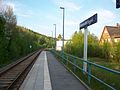
Hp Meinersdorf (Erzgeb) with former reception building (right) (2016)
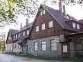
Meinersdorf (Erzgeb) station, former reception building (2016)
_mit_ehem._Empfangsgeb%C3%A4ude.JPG)
_Empfangsgeb%C3%A4ude_(1).JPG)
Development of the population
In the course of industrialization Meinersdorf experienced a population increase from 672 inhabitants in 1834 to 1144 inhabitants in 1871. For the year 1925, a population of over 2000 was measured for the first time. The highest number of inhabitants was measured in the post-war period of World War II in 1950. This year 2629 inhabitants lived in the place. In the following GDR period, the population fell again to 1656 in 1990. Before it was incorporated into Burkhardtsdorf in 1999, the community had 1673 inhabitants. At the end of February 2013, 1,441 people lived in the village.
|
|
|
1 Status: August 31st
2 Status: February 28th
Worth seeing

In addition to some circular hiking trails with various viewpoints, there is a used Kneipp water treading basin. The Meinersdorf Church was rebuilt in 1812. There is also a place pyramid in the village .
Personalities
The following people were born or worked in Meinersdorf:
- Walter Breitfeld (1903–1981), head of the political administration of the border troops in the GDR
- Horst Strohbach (1886–1978), local history researcher
- Ernst Kühn (1859–1943), architect of the Meinersdorf community school
literature
Richard Steche : Meinersdorf. In: Descriptive representation of the older architectural and art monuments of the Kingdom of Saxony. 7th issue: Amtshauptmannschaft Chemnitz . CC Meinhold, Dresden 1886, p. 47.
Web links
- Data and photos about the place
- Meinersdorf in the Digital Historical Directory of Saxony
Individual evidence
- ↑ a b Meinersdorf. In: burkhardtsdorf.de. Burkhardtsdorf community, accessed on March 10, 2013 .
- ↑ a b Cf. Meinersdorf in the Digital Historical Directory of Saxony
- ↑ Siegfried Bergelt: On the trail of the old West Saxony Mainline - the Chemnitz – Aue – Adorf railway line . Bildverlag Böttger, Witzschdorf 2004, p. 56.
- ↑ Federal Statistical Office (Ed.): Municipalities 1994 and their changes since 01.01.1948 in the new federal states . Metzler-Poeschel, Stuttgart 1995, ISBN 3-8246-0321-7 .
- ↑ Thum - Meinersdorf. In: stillgend.de. Martin Wollmann, accessed March 10, 2013 .
- ^ Changes in the municipalities in Germany. Federal Statistical Office, accessed on March 10, 2013 .
- ^ Jürgen Viehweger: The Zwönitztalbahn Chemnitz – Aue . Verlag Jacobi, Fraureuth 2006, p. 70.
- ↑ Changes in population / area for 14 1 88 170 community Meinersdorf. In: Regional Register Saxony. State Statistical Office of Saxony , accessed on March 10, 2013 .
