
Nama foreland basin
The Nama-foreland basin is in the regional geology of South West Africa an intra-continental foreland basin ( English Foreland basin ) northwest of the Kalahari - craton . It developed during the tectonic convergence phases of the Congo-São Francisco cratons (Congo-SF for short) and Kalahari. For a long time this basin absorbed massive sediment deposits.
These processes are related to the disintegration of the supercontinent Rodinia and the new formation of the greater continent Gondwana , which u. a. led to the formation of the Damara Belt and the Gariep Belt .
The evolution of the Nama foreland basin took place around 600 million years ago. The main sedimentary phases extended over a period of 570 to 510 million years, abbreviated mya , instead.
Origin of name
The name "Nama" was coined in 1885 by Adolf Schenck . It is based on the original expression "Namaqua slate, sandstone and limestone" for the almost horizontal layers in central and southern parts of the former German South West Africa . This expression was later shortened to "Namaqua" and finally even shorter to "Nama".
The sedimentary Nama Group (Engl. Nama Group) (see → Sedimentary Nama Group ) was after multiple changes and involvement of various authors the name and lithostratigraphic defined outline of GJB Germs 1,983th
Position and extent


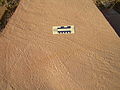
The Nama foreland basin extends in a north-south direction from the settlement of Klein Aub in the Namibian region of Hardap north of the Naukluft Mountains to the Fish River Canyon in the south of Namibia over a length of 450 km.
To the north and northwest, the deposits in this sedimentary basin are bounded by the emerging 1,800 my old units of the Rehoboth inlier. To the south-west and south, branches of the 1,300 mya old Namaqua Metamorphic Complex join, which also forms the basement of the Gariep Belt and to which the Nama foreland basin extends with a small area. To the east, the Nama sediments are covered by younger deposits of the Kalahari, which are assigned to the Karoo supergroup and developed from 300 mya. The greatest width is about 200 km.
Geodynamic framework
The supercontinent Rodinia had formed around 900 mya. The Congo-São Francisco-Kraton (abbreviated Congo-SF), the Kalahari and the Río-de-la-Plata-Kraton were connected.
In the period from 780 to 740 mya, intra-continental rifts, initiated by the superplume events , developed along a triple junction (triple point) between the cratons Congo-SF and Kalahari and the Río de la Plata-Kraton. The cratons broke apart. The Adamastor Ocean formed between the “African” land masses on the one hand and the “South American” continental floe on the other. In the spreading rift valley between the Congo-SF craton and the Kalahari craton, water from the Adamastor Ocean penetrated and formed the Khomas Sea.
From 655 mya, the divergence phase was followed by the convergence phase between the cratons Congo-SF and Kalahari. The Damara and Gariep belts developed. Also the Kalahari-Kratons partially subducted and the Congo-SF craton. Due to the load of this continental block, a section of the crust of the Kalahari craton sank in the area of the subduction zone and thus formed a lithospheric depression . From this, the Nama-foreland basin was that accordingly as Peripheral foreland basin (Engl. Peripheral foreland basin) is classified. The age is assumed to be around 600 mya.
As a result, the Nama foreland basin absorbed massive sediment deposits from the eroding surrounding mountains; with this reference it has become a sedimentary basin . It is geologically subdivided by a bulge of the basement running in a west-east direction into the northern Zaris basin and the southern Witputs basin. The Nama foreland basin came under relatively shallow seawater cover, which fluctuated several times between transgressions , the rise in sea level, and regressions , the receding sea level.
During the subduction of the Kalahari craton, the sediments already deposited in the northern area of the Nama foreland basin were driven over by the Naukluft Nappe Complex up to 520 mya. The subduction caused the complex to be sheared from the subsurface and pushed over the sediments. It thus forms an allochtonic tectonic blanket that is about 80 km from the place of formation .
Geological floors
Cratonic basement
The Nama foreland basin is located in the northern area on the 1,200 my old Sinclair sequence of the Rehoboth Inlier. This inlier is named after the town of Rehoboth in the Hardap region and can be understood as a block of crust that accumulated on the northwestern edge of the Kalahari craton as an accretion wedge . The southern area of the Nama foreland basin is based on the similarly old Namaqua Metamorphic Complex, which is also known as the Namaqua-Natal Belt. These basement units were formed during the Kibaran orogeny, which led to the formation of the supercontinent Rodinia.
Sedimentary Nama Group
The entirety of the sediments in the Nama foreland basin is referred to as the Nama group, which is lithostratigraphically divided into the Kuibis subgroup, the Black Edge subgroup and the Fish River subgroup. These are divided into formations and various other subdivisions. They were deposited over a period of 570 to 510 mya.
The sediments deposited at the bottom come directly from the Kalahari craton. The later deposits come from delivery areas of the eroding mountains of the Damara and Gariep belts.
The two lowest Nama subgroups developed in zones close to the shore to deeper areas outside the surf zone or below the wave base. The sedimentation phases took place in a repeatedly changing regime of seaward retreat of the coastline or sea level decline and landside advancement of the coastline or sea level advance . The uppermost subgroup forms alluvial soils up to shallow marine molasses , which come from the erosion debris of the eroded Damara orogeny.
The following zones can be assigned to the deposition environments :
- Area near the shore or coastal front with tidal effects or from the mean fair-weather wave base to the mean low water area,
- coastal zone between medium fair weather wave base to medium high water level,
- middle coastal zone or transition zone between mean fair weather and mean storm wave base,
- lower coastal zone from mean storm wave base and below.
The wave base is the area in which the waves touch the ground for the first time and can lead to the displacement or change of the surfaces of the sediments.
Kuibis subgroup
The basal Kuibis subgroup sedimented directly on the eastern flank of the Rehoboot Inlier in the southern and northern Nama sub-basins. It is characterized by a sandstone and a carbonate-dominated formation.
- In the deepest zone of the southern Witputs Basin, the sandstone-dominated Dabis formation lies with a thickness of about 200 m. The lowest layer consists of coarse, flat sandstones, which have small ripples and dry cracks . From this it is concluded that the environment was formed in a tidal zone near the shore with the effects of tides . Above this follows a carbonate sequence with irregularly laminated layers of fine-grain dolomite stones and limestones . Its layers were mainly deposited in shallow coastal environments influenced by waves . The following is a thick layer of diagonally layered medium coarse sand stones that are in influenced by tidal upper shore or river delta were deposited -Millieus. When the sea level was low, it spread over the local carbonate sequence and was largely preserved during the landside advancement of the coastline . The uppermost, thin layer is again characterized by carbonates and consists of relatively thinly layered limestones, in which irregularly shaped breccias are contained. The graduated strata and rib marks indicate a storm-influenced sedimentation environment in central to deeper coastal zones.
- In the northern Zaris basin, the carbonate-dominated Zaris formation separated out. Due to the gradation from the shallow water environment in the south to deeper sea zones in the north of the sub-basin, the sediment thickness increases to around 500 m. The sequence of layers begins with a thin layer of coarse sandstones and basement rock fragments directly on the Cratonic basement . It was deposited there during large-scale transgression. This is followed by a massive layer of diagonally stratified limestone silites , which arose in coastal zones from the middle storm wave base (hummocky cross-stratification) (see also → stratification ). This is followed by a layer of obliquely layered, relatively fine-grain carbonates (Grainstone) (see also → Dunham classification ). In developed biofilm (. Thrombolites English) and structures from Thrombolithen stromatolites with photosynthetic cyanobacteria . These layers emerged during a transgression high sea level in shallow coastal zones above the fair-weather wave base. Another layer of very fine-grain clay stones or mud and limestone and other components (English heterolithic bedding) separates again deposited thrombolithic and stromatolithic structures. At 549 mya volcanic ash was deposited directly above these structures; thus the age of these structures is determined. The uppermost layers in turn form a carbonate sequence of thinly layered limestones, very fine-grained claystones as well as embedded lime silites and lime arenites . These show oblique stratifications and large storm-induced ripple marks that arose in central coastal zones and were subject to both transgressive and regressive influences.
Black border subgroup
The black border subgroup uniformly overlays the Kuibis subgroup . It sedimented only in the southern Witputs Basin and reached a thickness of about 1.2 km, where it adjoins the Kuibis subgroup to the west.
- The basal Nudaus Formation consists mainly of fine to very fine-grain siliciclastic siltstones and claystones as well as sandstones. It was deposited in coastal areas influenced by tides and estuaries .
- Above it follows the Urusis Formation, which forms a mighty carbonate platform . It interlocks with the Nomtsas formation in the upper area. They contain cycles that contain lime-silite, lime- arenite and fine-grained grainstones as well as thrombolite and stromatolite reef structures . They developed in shallow water zones above the fair-weather wave base, with the reef cones documenting the sea level at that time. You are surrounded by green siltstones and claystones. This is followed by a carbonate sequence consisting of thinly layered limestone silites with local thrombolite and stromatolite formations, the age of 545 mya of which could be determined from volcanic ash deposits . The sedimentation occurred in lower, low-energy coastal zones, near the storm wave base. Further volcanic ash was deposited in 543 and 539 mya.
For more information on the thrombolite and stromatolite formations see → Evolutionary developments .
Fish River subgroup
The Fish River subgroup forms the uppermost and easternmost deposit sequence. It covers the black border subgroup irregularly . The rocks of the Fish River subgroup can be viewed as molasses or erosion debris from the eroding orrogens of the Damara Belt. The age of these sediments and sedimentary rocks spans a period of approximately 570 to 500 mya. The initial deposit took place in the Khomas Sea. After its subduction under the Congo-SF craton between 550 and 520 mya, rivers were transported to the Nama foreland basin, where alluvial soils were deposited in several formations. From the lack of large rubble it is concluded that conglomerates and conglomerate sandstones originate from distal, distant delivery areas.
- The basal Stockdale formation in the lowest bank consists mainly of conglomerates that have developed into rubble . They are deposited in several horizons . Frequently, quartz , feldspar , Lydit or radiolarite and Tongerölle represented. Red jasper is characteristic of the conglomerates . Gray-green to red-brown-purple colored layers of silt and clay are embedded between the horizons . From strongly rounded rubble stones , which are rarely larger than 2 cm, as well as inclined stratifications in the horizons in places , it is concluded that there is fluvial water transport from distal, distal delivery areas. The relatively flat horizons of less than 1.3 m often branch out within a length of up to 30 m. This indicates the backfilling of running water channels. Regionally different sediments are deposited on the conglomerate horizons. They are purple-gray, arkosely sloping sandstones in which silty and clayey intermediate layers as well as clay pebbles are switched on. The sandstones form lenses more than 20 m in length. Another locality is characterized by green, fine manganese silt layers, which alternate with green claystone layers. Both are overlaid by mighty diagonally layered violet arcoses .
- In the next Breckhorn Formation, purple-gray quartzitic sandstones with local mica accumulations predominate.
- This is followed by the Nababis formation of mostly red-brown siltstones with mica enrichments that contain mudstone oils . They form few, relatively thin layers and are separated by clay layers. This sequence is overlaid by red-brown sandstones with also clayey intermediate layers that show locally sloping layers. In places there are red siltstones and sandstones, which are underlain by rubble-bearing claystones.
- The uppermost Groß Aub formation consists at the bottom of finely stratified layers of green to gray siltstones and fine sandstones with typical green and red fine bands and mica enrichments. These obliquely layered layers contain claystone oils with a grain size distribution . This is followed by red-brown, sloping sandstone deposits that contain only a few siltstone / claystone intermediate layers. Mica- rich siltstone and sandstone layers with large ripple fields appear locally or gray, mica-rich, thin-layered quartzites and red mica-poor sandstones that are obliquely layered and overlaid by red claystones.
Evolutionary developments
In the sedimentary Nama group, the important Nama fossil community developed during the Ediacarium (635 to 541 mya) (see → Nama community ), its typical representatives also in southern China , British Columbia , Canada and the Mojave desert of North America were found.
Biogenic sedimentary rocks
In the Kuibis and Schwarzrand subgroups, thrombolite and stromatolite biogenic structures have developed in some of the carbonate platforms. Thrombolites form internally clumped microorganisms , not layered structures, while stromatolites are usually built up internally in layers. Both are based on biofilms , mostly from cyanobacteria , and temporarily stored , binding sediment particles. Stromatolites and thrombolites can photosynthesize .
In the Kuibis subgroup, two thrombolite / stromatoloth biofilms developed in the northern Zaris basin. For the upper biofilm structure, which lies roughly in the middle of the sediment package, an age of around 549 mya was determined using the isotope geochemistry of volcanic ash . The black rim subgroup contains reef formations whose age at 545 mya was also determined on the basis of volcanic ash deposits.
The thrombolite and stromatolite structures form lateral, coherent biofilms, isolated patch reefs or isolated cone reefs (pinnacle reefs). Patch reefs usually form small reef structures between 3 and 6 m high and 5 to 50 m in diameter with a columnar or mushroom-shaped outline. Pinnacle Reefs reach dimensions from one meter to several kilometers. In most cases, the reefs developed during the high level of the sea (Highstand Systems Tract (HST)) (see → sequence stratigraphy ). Both biogenic structures are closely associated with the first calcified metazoa to appear . These possibly lived together as colonies or protected in depressions in the biofilms or reefs.
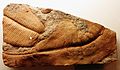
The overlying Fish River subgroup contains significant trace fossils , including the well-known Treptichnus pedum . It is believed to be the earliest widespread, three-dimensional complex trace fossil. The finds are either in layers of sediment that still contain Ediacara saunas or layers immediately above them. Treptichnus pedum thus defines the beginning of the Cambrian .
Body and trace fossils

Schemas of Trichophycus pedum feeding traces of movement
Traces of movement from Diplichnites

Reconstruction of Swartpuntia
Pteridinium simplex fossil

Aspidella fossil print

Reconstruction of Cloudina

Reconstruction of Namacalathus


A large number of body fossils have been preserved in Nama sediments . These are predominantly very primitive multicellular animals , whose affiliation to later living forms is not possible or only with difficulty. Typical taxa are the frondomorphic (frondomorphic) Swartpuntia , Ernietta , the skeletal Pteridinium , Aspidella , Cloudina and Namacalathus as well as the trace fossils Trichophycus pedum and Diplichnites.
The representatives of the Ediacara fauna are no longer present in the subsequent Cambrian (541 to 485.4 mya). The influence of the more modern fauna is believed to be the cause of the extinction . During the Cambrian Explosion, almost all representatives of today's animal phyla developed . The basic body plans of many multicellular animal groups that have developed since then have been passed down clearly for the first time.
Web links
- PG Gresse, GJB Germs: The Nama foreland basin: sedimentation, major unconformity bounded sequences and multisided active margin advance. In: Precambrian Research. Volume 63, Issues 3-4, November 1993, pp. 247-252, 259-272. doi: 10.1016 / 0301-9268 (93) 90036-2 , (Link)
Individual evidence
- ↑ a b Rudolf Nagel: One billion years of geological development on the NW edge of the Kalahari Kraton. Dissertation. Georg-August-Universität zu Göttingen, Göttingen 1999. ( ediss.uni-goettingen (PDF) )
- ^ A b Julia Bail: The Mesoproterozoic evolution of the central Namaqua Metamorphic Complex (South Africa and Namibia): Petrology, geochemistry and geochronology. Dissertation. Christian-Albrechts-Universität zu Kiel, 2015. (Link)
- ^ ZX Li, SV Bogdanova, AS Collins, A. Davidson, B. De Waele and others: Assembly, configuration, and break-up history of Rodinia: A synthesis. In: ScienceDirect, Precambrian Research. 160, 2008, pp. 179-210. (bdewaele.be PDF)
- ↑ Fernandez-Alonso and others: The Proterozoic History of the Proto-Congo Craton of Central Africa. Department of Earth Sciences, Royal Museum for Central Africa, B-3080 Tervuren, Belgium of Central Africa. ( africamuseum.be PDF )
- ↑ Armin Zeh, Axel Gerdes, Jackson M. Barton, Jr .: Archean Accretion and Crustal Evolution of the Kalahari Craton — the Zircon Age and Hf Isotope Record of Granitic Rocks from Barberton / Swaziland to the Francistown Arc. In: Journal of Petrology. Volume 50, No. 5, 2009, pp. 933-966. (Link)
- ↑ Pedro Oyhantçabal Siegfried Siegesmund, Klaus Wemmer: The Río de la Plata Craton: a review of units, boundaries, ages and isotopic signature. In: International Journal of Earth Sciences. Volume 100, Issue 2, April 2011, pp. 201-220. doi: 10.1007 / s00531-010-0580-8
- ↑ Hartwig E. Frimmel, Peter G. Fölling: Late Vendian Closure of the Adamastor Ocean: Timing of Tectonic Inversion and Syn-orogenic Sedimentation in the Gariep Basin. In: Gondwana Research. V. 7, no. 3, 2003, pp. 685-699. (Link)
- ↑ Giulio Viola, Neil S. Mancktelow, Jodie A. Miller: Cyclic frictional-viscous slip oscillations along the base of an advancing nappe complex: Insights into brittle-ductile nappe emplacement mechanisms from the Naukluft Nappe Complex, central Namibia. In: Tectonics. June 16, 2006. (Link)
- ↑ L. Tack, MTD Wingate, B. De Waele, J. Meert and others: The 1375 Ma Kibaran event in Central Africa: Prominent emplacement of bimodal magmatism under extensional regime. In: Precambrian Research. Volume 180, Issues 1-2, June 2010, pp. 63-84. (Link)
- ↑ a b Uwe E. Horstmann: The metamorphic development in the Damara Orogen, Southwest Africa / Namibia, derived from K / Ar dating on detritic light mica from molasses sediments of the Nama Group. Dissertation. Georg-August-Universität, Göttingen 1986. (geobiologie.uni-goettingen PDF)
- ^ Joseph G. Meert, Elizabeth A. Eide, Trond H. Torsvik: The Nama Group revisited. In: Geophys J Int. 129 (3), 1997, pp. 637-650. doi: 10.1111 / j.1365-246X.1997.tb04499.x
- ↑ a b Beverly Z. Saylor, Alan J. Kaufmann, John P. Grotzinger, Frank Urban: A Composite Reference Section for Terminal Proterozioc Strata of Soutern Namibia. Department of Geological Sciences, Case Western Reserve University, Cleveland, Ohio 44105, USA (geol.umd PDF)
- ^ John P. Grotzinger: Facies and paleoenvironmental setting of Thrombolite-Stromatolite Reefs, Terminal Proterozoic Nama Group (approx. 550-543 Ma), central and southern Namibia. In: Communs geol. Surv. Namibia. 12, 2000, pp. 251-264. (mme.gov PDF)
- ↑ Simon AF Darrocha, Thomas H. Boag, Rachel A. Racicot, Sarah Tweedt and others: A mixed Ediacaran-metazoan assemblage from the Zaris Sub-basin, Namibia. In: Palaeogeography, Palaeoclimatology, Palaeoecology. Volume 459, October 1, 2016, pp. 198–208. (Link)