
Pagondas (Samos)
|
Municipality of Pagondas Δημοτική Κοινότητα Παγώνδου (Παγώνδας) |
|||
|---|---|---|---|
|
|||
| Basic data | |||
| Country |
|
||
| region | North Aegean | ||
| Regional district | Samos | ||
| local community | Anatoliki Samos | ||
| Parish | Pythagorio | ||
| status | Borough | ||
| Geographic coordinates | 37 ° 40 ′ N , 26 ° 50 ′ E | ||
| Height above d. M. |
156 m (average) |
||
| surface | 34.160 km² | ||
| Residents | 1395 (2011) | ||
| LAU-1 code no. | 56010407 | ||
| Local division | 3 | ||
| Telephone code | 22730 | ||

Pagondas ( Greek Παγώνδας ( m. Sg. )) Is a village in the Pythagorio municipality in the south of the Greek island of Samos . Together with the coastal town of Ireo , once the port of Pagondas with the nearby ancient sanctuary and UNESCO World Heritage Site Heraion of Samos and Kolona, it forms the municipality of Pagondas (Δημοτική Κοινότητα Παγώνδου) with 1395 inhabitants in 2011.
location

Pagondas is located like an amphitheater on the southeastern foothills of the Ambelos Mountains at about 180 meters above sea level and offers a panoramic view to the east over the plain of Chora (Κάμπος Χώρας Kambos Choras ) and the adjacent Aegean Sea . The village is about 12 kilometers west of the airport . Pagondas is accessible by road links from Pythagorio, Ireo and Pyrgos .
The area of the municipality of Pagondas (Τοπική Κοινότητα Παγώνδου) extends in the south of the island over an area of 34,610 square kilometers. This makes Pagondas the second largest village in the municipality of Pythagorio after Mytilinii (Δημοτική Ενότητα Πυθαγορείου) and fourth largest in the municipality of Samos. Adjacent urban districts and local communities are Spatharei in the west , Pyrgos , Koumaradei and Myli in the north, and Chora in the northeast . In the east and south the area extends to the coast.
history
The place is one of the oldest villages on the island and was founded like the neighboring Myli in the second half of the 16th century. According to the oldest written evidence from 1677, the village of Pagontas consisted of no fewer than 300 houses and 2 churches. A silk factory was operated in the village. In a listing in 1702 , Tournefort mentioned the village of Bavonda without any further information.
Since the middle of the 19th century, the village was under the administration of Khoras . The French explorer Victor Guérin describes Pagonda in 1856 with 350 houses, 4 churches and a school. He mentions the 200 year tradition of silk production. In 1869 the village consisted of 410 houses, with three churches and a school. Most of the 1525 inhabitants were farmers.
According to Hauttecœur , the village had 3,387 inhabitants at the beginning of the 20th century, and their main source of income was growing onions and producing olive oil and silk.
After the island of Samos was annexed to Greece, Pagondas became an independent rural community in 1918 (Κοινότητα Παγώνδου Kinotita Pagondou ). The fishing village of Ireo was recognized as a settlement in 1940, Kolona in 1991. Due to the territorial reform in 1997 , Pagondas was merged with 10 other rural communities to form what was then Pythagorio . The administrative reform in 2010 brought the former municipalities of the island together to form the new municipality of Samos (Δήμος Σάμου Dimos Samou ). Since then, Pagondas has had the status of an urban district (Δημοτική Κοινότητα).
- Population development of Pagondas
| Surname | Greek name | 1913 | 1920 | 1928 | 1940 | 1951 | 1961 | 1971 | 1981 | 1991 | 2001 | 2011 |
|---|---|---|---|---|---|---|---|---|---|---|---|---|
| Pagondas | Παγώνδας | 2641 | 2414 | 2436 | 2570 | 2186 | 1899 | 1380 | 1141 | 980 | 764 | 518 |
| Ireo | Ηραίο | 61 | 99 | 122 | 102 | 210 | 417 | 495 | 849 | |||
| Kolona | Κολόνα | 9 | 35 | 28 | ||||||||
| total | 2451 * | 2436 | 2631 | 2285 | 2021 | 1482 | 1351 | 1406 | 1294 | 1395 | ||
* including 37 residents of Metochis Sarakini in the Monastery of St. John of Patmos
economy
The fertile soil is particularly suitable for the cultivation of wine and olives. Other typical high quality products from the Pagondas area include wood, cheese, honey, vegetables and fruits.
Oil mill in Pagondas
The old mill at the entrance to the village is probably the oldest of 65 oil mills on Samos. The hall was built by Odisséas Manoliádes in 1890 and operated by him until 1940. His successor was his son Kostas, who ran it until 1970 in order to leave it to his son, Georgios Manoliádes, who is currently 71 years old (2008) and will hand it over to his son Kostas.
The hall originally dates from 1890. The current machine park has only been in operation for the third season. Originally, a large steam engine operated the entire system via V-belts (until 1955). Then it was replaced by diesel engines (1955–1967). Today the machines work with electricity. A boiler that is heated with olive pomace still produces only the hot water required .

Oil mill at the entrance to Pagondas
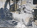
old steam engine

new centrifugation station

Manoliádes family


The plant is in operation for about four months per year (approx. November 10th to the end of March) and presses 280-300 tons of olives per season. This produces around 160-180 tons of oil. The pomace temporarily stored on the outside of the oil mill is refined in a factory in Ormos Marathokambou and processed into soaps and shampoos. The residues left there are used in Pagondas as fuel for the hot water boiler.
Worth seeing
Count to the numerous sights of the place
- the Church of the Holy Trinity from 1872 with an attached church museum, which houses several icons from the 17th century and other works of art.
- the Christ Church from the 16th century with a marble bell tower, which has been declared a national cultural heritage by the Ministry of Culture.
- several smaller chapels in honor of Agios Paraskevi, Agios Panteleimon, Agia Panagista, Agios Konstantinos, Agios Elias Hamilos, Agios Giorgos and others
In addition to the old school, which has been converted into an event center and folklore museum, and the public washrooms from the 19th century (Megali Vrisi), the old oil mill (olive factory) at the entrance to the village is also one of the sights.
Daughters and sons of the place
Pagondas is the birthplace of the novelist Alkis Angeloglou and the poet and writer Kostas Karathanasis.
Coast at Pagondas

Coast below Pagondas

Tsopela Beach
below Pagondas


literature
- Κεντρική Ένωση Δήμων και Κοινοτήτων Ελλάδας, Ελληνική Εταιρία Τοπικής Ανάπτυξης και Αυτοδιοίκησης (ed.): Sanakirja Διοικητικών Μεταβολών των Δή microns ων και Κοινοτήτων (1912-2001) . 2 (Τόμος Α, α – κ). Athens 2002, ISBN 960-7509-47-1 .
Individual evidence
- ↑ National Statistical Service of Greece (ΕΣΥΕ) according to 2001 census , p. 117 (PDF, 793 kB)
- ↑ a b Results of the 2011 census, Greek Statistical Office (ΕΛ.ΣΤΑΤ) ( Memento from June 27, 2015 in the Internet Archive ) (Excel document, 2.6 MB)
- ^ Iosif Georgirinis: A description of the present state of Samos, Nicaria, Patmos, and Mount Athos . London 1678 ( limited preview in Google Book search).
- ^ Joseph Pitton de Tournefort: LETTRE X. Description des Isles de Samos de Patmos de Fourni & de Skyros . In: Relation d'un voyage du Levant: fait par ordre du Roi contenant . Lyon 1717, p. 104 ( online ). (French)
- ↑ Victor Guerin: Description de l'ile de Patmos et de l'ile de Samos . 1856, p. 247 .
- ↑ Emmanouil kritisidis (Εμμανουήλ Κρητικίδης): Τοπογραφία αρχαία και σημερινή της Σάμου . 1869, p. 80 ff .
- ↑ Henry Hauttecœur: La principauté de Samos . tape II . Vanderauwera & Cie, 1901, p. 112 .
- ↑ Λεξικό ∆ιοικητικών Μεταβολών των ∆ή µ ων και Κοινοτήτων (1912-2001) . tape 2 , 2002, p. 248 .
- ↑ Λεξικό ∆ιοικητικών Μεταβολών των ∆ή µ ων και Κοινοτήτων (1912-2001) . tape 2 , 2002, p. 361 .
- ↑ Population of Pagondas 1913-2001, Greek Statistical Office ELSTAT, digital library (Greek)
Web links
- Community website (Greek, English, German)
- Places on Samos (English)
- Pagondas (Greek, English, German, French)
- The bay of Tsopela near Pagondas