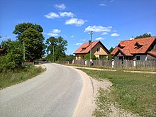
Pogobie Tylne
| Pogobie Tylne | ||
|---|---|---|

|
|
|
| Basic data | ||
| State : | Poland | |
| Voivodeship : | Warmia-Masuria | |
| Powiat : | Pisz | |
| Gmina : | Pisz | |
| Geographic location : | 53 ° 32 ' N , 21 ° 45' E | |
| Residents : | 65 (2011) | |
| Postal code : | 12-200 | |
| Telephone code : | (+48) 87 | |
| License plate : | NPI | |
| Economy and Transport | ||
| Street : | Ruciane-Nida / DK 58 - Wiartel - Kulik → Pogobie Tylne | |
| Rail route : | no rail connection | |
| Next international airport : | Danzig | |
Pogobie Tylne [ pɔˈɡɔbjɛ ˈtɨlnɛ ] ( German Hinter Pogobien, 1933 to 1945 Hirschwalde ) is a village in the Polish Warmian-Masurian Voivodeship that belongs to the Gmina Pisz ( city and rural community of Johannisburg ) in the powiat Piski (district of Johannisburg ).
Geographical location
Pogobie Tylne is located on the southwestern shore of the Kleiner Pogobier See (also: Mittelpogauer See, in Polish Jezioro Pogubie Małe ) in the southeastern Warmian-Masurian Voivodeship, twelve kilometers south of the district town of Pisz ( German Johannisburg ).
history
The heath village Hinter Pogobien was founded in 1707 as a casket settlement. In 1874 the village was incorporated into the newly established Kullik ( Polish: Kulik ) district, to which it was assigned with its localities of Grodzia (1933 to 1945 Vogelsang , Polish Grodzie ) and Janina (1933 to 1945 Hirscheck , Polish Janina ) until 1945.
In 1910 a total of 301 inhabitants were registered in Hinter Pogobien. On January 20, 1933, the village was renamed "Hirschwalde". The population in that year was 274 and was 297 in 1939.
As a result of the war, the village came to Poland in 1945 with all of southern East Prussia and was given the Polish form of name "Pogobie Tylne". Today the village is the seat of a Schulzenamt ( Polish Sołectwo ) and is therefore a place in the network of the city and rural community Pisz (Johannisburg ) in the Powiat Piski ( Johannisburg district ), until 1998 of the Suwałki Voivodeship , since then it belongs to the Warmia-Masurian Voivodeship . In 2011 Pogobie Tylne had a total of 65 inhabitants.
Religions
Until 1945, Hinter Pogobien was parish in the Evangelical Church of Johannisburg in the church province of East Prussia of the Church of the Old Prussian Union and in the Roman Catholic Church in Johannisburg in the Diocese of Warmia .
Today, on the Catholic side, Pogobie Tylne belongs to the parish church in Wiartel ( German (Groß) Wiartel ) or in Turośl (Turoseeling , 1938 to 1945 Mittenheide) in the diocese of Ełk of the Roman Catholic Church in Poland . The Protestant residents orientate themselves towards the parish in Pisz in the diocese of Masuria of the Evangelical-Augsburg Church in Poland .
school
Behind Pogobien became a school location in 1737.
traffic
Pogobie Tylne is located on a side road that runs from Ruciane-Nida (Rudczanny , 1938 to 1945 Niedersee - Nieden) via Wiartel ( (Groß) Wiartel ) and Kulik (Kullik) to here.
Individual evidence
- ↑ Polish Postal Code Directory 2013, p. 946
- ↑ a b Dietrich Lange, Geographical Location Register East Prussia (2005): Hirschwalde
- ↑ a b c Behind Pogobien - Deer forest in family research Sczuka
- ^ Rolf Jehke, Kullik District
- ↑ Behind Pogobien, Hirschwalde, Pogobie Tylne at genealogy.net
- ^ Uli Schubert, community directory, district Johannisburg
- ^ Michael Rademacher: German administrative history from the unification of the empire in 1871 to the reunification in 1990. District Johannisburg (Polish Pisz). (Online material for the dissertation, Osnabrück 2006).
- ↑ Sołtysi w Gminie Pisz
- ↑ Pogobie tylne in Polska w liczbach
- ^ Walther Hubatsch , History of the Protestant Church in East Prussia , Volume 3 Documents , Göttingen 1968, p. 491


