Prague 12
| Prague 12 | |||
|---|---|---|---|
|
|||
| Basic data | |||
| State : |
|
||
| Region : | Hlavní město Praha | ||
| Municipality : | Praha | ||
| Area : | 2333 ha | ||
| Geographic location : | 50 ° 1 ' N , 14 ° 24' E | ||
| Residents : | 55,040 (December 31, 2015) | ||
| Postal code : | 142 00, 143 00 | ||
| structure | |||
| Status: | District ( městská část ) | ||
| administration | |||
| Mayor : | Daniela Rázková (as of 2016) | ||
| Address: | Písková 830/25 143 12 Prague 12 |
||
| Website : | www.praha12.cz | ||
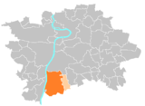
Prague 12 is an administrative district and a district of the Czech capital Prague . The district is located on the right bank of the Vltava River on the southern edge of the city.
structure
The Prague 12 administrative district comprises the two districts of Prague 12 and Libuš .
The Prague 12 district consists of the five cadastral municipalities Cholupice , Kamýk , Komořany , Modřany and Točná . From 1990 to 1994 the district was called Praha-Modřany .
traffic
Točná airfield is located in the area of the district . In addition, the Dobříš – Praha-Modřany railway with the Praha-Komořany and Praha-Modřany stations runs here . The latter is connected to the tram and bus network and is therefore an important transfer hub.
Attractions
- Modřany Gorge
- Modřany vineyard
- Komořany Castle


