
Redkino (Tver, Konakowski)
| Urban-type settlement
Redkino
Редкино
|
||||||||||||||||||||||||||||||||||||
|
||||||||||||||||||||||||||||||||||||
|
||||||||||||||||||||||||||||||||||||
| List of large settlements in Russia | ||||||||||||||||||||||||||||||||||||
.png)

.svg)

Redkino ( Russian Ре́дкино ) is an urban-type settlement in Tver Oblast ( Russia ) with 11,703 inhabitants (as of October 14, 2010).
geography
The settlement is located about 35 km southeast of the Tver Oblast Administrative Center between the northeast flowing Volga and its southern right tributary Shosha . The place is a good 6 km away from both rivers, which are dammed up there to the Iwankowoer reservoir .
Redkino belongs to the Konakovsky district and is located 30 km west-southwest of its administrative center Konakowo . It is the seat and only village of the municipality of the same name (gorodskoje posselenije).

Redkino train station
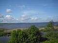
Ivankovo Reservoir south of Redkino, from the railway line


history
In 1851, the Nikolaibahn from Saint Petersburg to Moscow passed the village of Redkino, which has been known since the 16th century, and a station was opened. As a result, a number of companies emerged in their vicinity. Towards the end of the 19th century, peat mining began on a large scale , and in 1902 a coking plant was opened, in which coke was made from peat; it burned down in 1905 and was not reopened until 1920.
When the Ivankowo Reservoir was flooded in the 1930s, some of the residents of the flooded villages were relocated to Redkino, which increased the population to over 4,000. In 1939 it was given the status of an urban-type settlement.
During the Second World War , Redkino was occupied by the German Wehrmacht from November 17 to December 13, 1941 . The coking plant, which had previously been blown up by the retreating Red Army , resumed operations in 1942, was converted into a chemical factory in the 1950s and remained a place-building company until its closure in the 1990s.
Population development
| year | Residents |
|---|---|
| 1939 | 1.918 |
| 1959 | 8,418 |
| 1970 | 12,233 |
| 1979 | 14,864 |
| 1989 | 13,448 |
| 2002 | 11,887 |
| 2010 | 11,703 |
Note: census data
traffic
Redkino is located at kilometer 517 of the Saint Petersburg –Moscow railway line, electrified on this section since 1957 , from which a freight connecting line branches off to the Isoplit settlement 6 km to the west . There are suburban trains to Moscow and Tver .
About 6 km northeast of the settlement, the M10 Rossija federal trunk road from Moscow to Saint Petersburg runs past the right bank of the Volga .
Individual evidence
- ↑ a b Itogi Vserossijskoj perepisi naselenija 2010 goda. Tom 1. Čislennostʹ i razmeščenie naselenija (Results of the All-Russian Census 2010. Volume 1. Number and distribution of the population). Tables 5 , pp. 12-209; 11 , pp. 312–979 (download from the website of the Federal Service for State Statistics of the Russian Federation)
| Cities |
Andreapol R | Bely R | Beschezk R | Bologoje R | Kalyasin R | Kashin R | Kimry S / R | Konakowo R | Krasny Cholm R | Kuwschinowo R | Lichoslavl R | Nelidowo R | Ostashkov R | Rzhev R S | Sapadnaya Dvina R | Stariza R | Subzow R | Toropez R | Torchok S / R | Tver S / R | Udomlja R | Vesyegonsk R | Wyschni Wolotschok S / R |
|
| Urban-type settlements |
Bely Gorodok | Firowo R | Isoplite | Kalashnikovo | Kessowa Gora R | Koslowo | Krasnomaiski | Kuschenkino | Maksaticha R | Molokowo R | Nowosawidowski | Olenino R | Orsha | Osjorny S / G | Peno R | Radchenko | Rameschki R | Redkino | Sandowo R | Sharkovsky R | Selisharovo R | Solnetschny S / G | Sonkowo R | Spirowo R | Staraya Toropa | Sukhowerkovo | Vasilyevsky Moch | Velikooktyabrsky |
|
| Another Rajon center |