
Waldems ring wall
| Waldems ring wall | ||
|---|---|---|
 Remains of the ramparts |
||
| Alternative name (s): | Ringwall Reichenbach, Ringwall "Burg" | |
| Creation time : | is controversial | |
| Castle type : | Hilltop castle | |
| Conservation status: | Burgstall, remains of a wall | |
| Place: | Waldems | |
| Geographical location | 50 ° 15 '52.5 " N , 8 ° 22' 48.7" E | |
| Height: | 459 m above sea level NHN | |
|
||

The ring wall system "Burg" , also known as the Waldems ring wall , is an abandoned hill fort ( Wallburg ). It is located in the southeast of the district of Reichenbach in the municipality of Waldems at 459 m above sea level. NHN meter high wooded elevation in the Hessian Rheingau-Taunus-Kreis , which bears the topographical name Burg .
Geographical location
The ring wall is located between the districts of Reichenbach, Niederems and Wüstems , which all belong to the municipality of Waldems. In addition to the remains of the ramparts in the forests, there are also references in the form of field names (“Auf der Burg”) and names. The system had a diameter of several hundred meters. The main visible remains of the complex can currently be found on the south side of the elevation.
history
The origin of the plant is disputed. In the context of local signs, the complex is assigned to Celtic origin, dating from around 500 BC. In terms of literature and experts, however, the complex was assigned to the early Middle Ages . It is probably the focus of a church clearing landscape, which originally goes back to a royal estate. It was given as a gift to the Georgsstift in Limburg together with Hof Camberg in 910 AD .
Up until around 1850 the ramparts were still more clearly visible, but these were probably largely removed in the course of agricultural and forestry use.
There is agreement that it was probably a refuge and in this sense is not a settlement.
Monument protection
The area of the ramparts is a ground monument according to the Hessian Monument Protection Act . Investigations and targeted collection of finds are subject to approval, and accidental finds are reported to the monument authorities.

Information board at Reichenbach

Local road sign in Niederems indicates the facility

The ring wall system sketched by Christian Ludwig Thomas

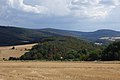
The Berg Burg , on which the rampart is located, seen from the southeast, near Wüstems
Castle , seen from the northwest, above Reichenbach , on the left at the edge of the picture the mountain Windhain , above the towers of the Großer Feldberg peep out, in the middle on the horizon Kleiner Feldberg , and in front of it the Weilsberg , which merges to the left into the Hühnerberg , in the back right the glass head above the Houses of Oberems as well as Wüstems below it .


literature
- Ulrich Dahmlos: Archaeological finds of the 4th to 9th centuries in Hessen.
- Karl August von Cohausen: The ramparts, military forces and old entrenchments of the administrative district of Wiesbaden . In: Nassau Annals . tape 15 .
Web links
- Entry by Reinhard Friedrich zu Reichenbach near Waldems in the scientific database " EBIDAT " of the European Castle Institute
- Reichenbach. Waldems community. (Description of the ramparts)
- Reichenbach, Rheingau-Taunus-Kreis. Historical local dictionary for Hessen. In: Landesgeschichtliches Informationssystem Hessen (LAGIS).

Adolfseck Castle | Schanze Adolfseck | Old Schanz | Old lock | Ringwall Altenstein | Ringwall old castle | Fortress Blideneck | Boosenburg | Brömserburg | Brömserhof | Crass Castle | Ringwall Dreibornskopf | Ehrenfels Castle | City Castle Eltville | Geroldstein Castle | Glimendal Castle | Greifenstein Castle | Ringwall Hallgarter Pliers | Haneck Castle | Hareschloß | Hattenheim Castle | Hohenbuchau Castle | Hohenstein Castle | Holdersberg Castle | Idstein Castle | Johannisberg Castle | Johannisberg Castle | Kammerburg | Lauksburg | Ring wall system Nack | Neuhaus Castle (Eltville) | Burgstall Neuhof (Taunusstein) | Niederwald Hunting Lodge | Nollig ruins | Palais Ostein Geisenheim | Plixholz ruin | Reichartshausen Palace | Reinhartshausen Castle | Rheinberg Castle | Rotenburger Schlösschen | Scharfenstein Castle | Schönborn Palace | Schwarzenstein Castle | Tower Castle Walluf | Vollrads Castle | Vorderburg (Rüdesheim) | Waldeck Castle | Waldems ring wall | Wallrabenstein Castle | Wehen Castle