
Santa Maria a Monte
| Santa Maria a Monte | ||
|---|---|---|

|
|
|
| Country | Italy | |
| region | Tuscany | |
| province | Pisa (PI) | |
| Coordinates | 43 ° 42 ' N , 10 ° 41' E | |
| height | 56 m slm | |
| surface | 38 km² | |
| Residents | 13,322 (Dec 31, 2019) | |
| Population density | 351 inhabitants / km² | |
| Post Code | 56020 | |
| prefix | 0587 | |
| ISTAT number | 050035 | |
| Popular name | Santamariammontesi | |
| Patron saint | Diana Giuntini | |
| Website | Santa Maria a Monte | |
 Panorama of Santa Maria a Monte |
||

Santa Maria a Monte is an Italian commune in the province of Pisa in the Tuscany region with 13,322 inhabitants (as of December 31, 2019).
geography

Santa Maria a Monte is about 35 km east of Pisa , on the right side of the Arno river . Part of the municipality is located in the southern part of the wooded range of hills Cerbaie , including the main town with its historic city center, the medieval village of Montecalvoli Alto and Cerretti . The southern part of the municipality lies in the Arno plain and is crossed by some canals, such as the Canale Usciana . The districts of Montecalvoli Basso , Ponticelli and San Donato are located here .
Santa Maria a Monte borders in the north and east on Castelfranco di Sotto , in the south, with the Arno as a border, on Pontedera and Montopoli in Val d'Arno , and in the west on Bientina and Calcinaia .
history
The hill of Santa Maria a Monte was settled in ancient times. The place ad Montem was first mentioned in a document from the year 776. From 787 a church with the name Santa Maria is attested. From 906 the area belonged to the diocese of Lucca . Due to its strategic location, the hill was expanded by Lucca around 1252 into one of the most important castles ( rocca ) in the Arno valley and was of great military importance. The Pisans captured the fortress in 1261 but were only able to hold it for a short time. She came back to Lucca, whose forces were led by Castruccio Castracani at the time . In 1327 Santa Maria a Monte fell to Florence and the old fortress was destroyed. Around the middle of the 14th century, the Florentines built the hill with three wall rings that are still recognizable today, and used the fortress as a starting point for conquering the entire lower Arno valley in the 15th century.
In the 16th century, the Tuscan Grand Duke Cosimo I had the Arno straightened. Parts of the old river basin can still be seen near San Donato. From the time of the Florentine rule, the place became an agricultural center in the lower Arno valley. Some noble families from Florence had estates built. In 1868 the previously independent municipality of Montecalvoli was merged with Santa Maria a Monte. In 1925 the municipality was transferred from the Province of Florence to the Province of Pisa.
Today Santa Maria a Monte is one of the municipalities of the Tuscan leather processing center in the Arno Valley ( comprensorio del cuoio ). One focus of agriculture is potato cultivation.
Culture and sights
Santa Maria a Monte has a characteristic spiral-shaped floor plan, which is derived from the walls of the former fortress. Medieval buildings are the Palazzo del podestà and the Torre dell'orologio, which is accessible as a lookout tower . At the highest point of the hill, excavations in recent years have discovered other remains of the old fortress, including a chapel and a cistern. Other attractions are:
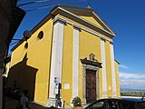
- Collegiata di San Giovanni Evangelista e di Maria Vergine Assunta - The church was consecrated in 1466. The campanile is a former tower of the fortress. The church contains some works from the 15th century, including a baptismal font by Domenico Rosselli (1468).
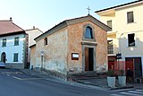
- Oratorio della Madonna delle Grazie - The small devotional chapel was built in 1498 after a plague epidemic.
- Chiesa dei Santi Giorgio e Jacopo - The church in Montecalvoli dates from the 13th century and was rebuilt in 1830.
- Museo Casa Carducci - The doctor Michele Carducci, father of Nobel Prize winner Giosuè Carducci, lived in the house . It is said that a tragedy, later literarily processed by the poet, took place here in 1857, in which Michele Carducci killed his son Dante with a scalpel.
- Casa Galilei - home of Galileo's father, Vincenzo Galilei
- Villa Medicea delle Pianore - The estate in the Arno Valley was initially laid out by the Medici for hunting and subsequently belonged to several noble families. The Chiesa di Santa Cristina alle Pianore belongs to the settlement . The church was built on the remains of an old Romanesque church and was consecrated in 1596.
- Osservatorio Astronomico di Tavolaia - Communal observatory

Santa Maria a Monte

The Torre dell'orologio
San Giovanni Evangelista

The campanile
Madonna delle Grazie
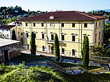
Palazzo Comunale , the town hall


.jpg)


Regular events
- Festa Patrona Beata Diana - Festival with procession in the main town, at Easter
- Festa Patrona Santa Cristina - Festival in Le Pianore in May, the first Sunday after Santa Cristina
- Festa Patrono San Jacopo - Festival in Montecalvoli in July, the first Sunday after San Giacomo
- Festa Patrono e Festa Paesana - Festival in San Donato, the second Monday of August
- Fiera dell'Assunta - festival in the main town, Monday after Ferragosto , with the Sagra della Patata - the theme is the culinary use of the potato
Town twinning
- Fontvieille , France, since 1991
Sons and daughters of the church
- Diana Giuntini (1287–1327) - saint and patron saint of Santa Maria a Monte
- Vincenzo Galilei (1520–1591) - composer, father of Galileo Galilei
- Romano Fogli (* 1938) - football player and coach
literature
- Toscana - Touring club italiano, Touring Editore (2005), ISBN 88-365-0948-7
Web links
Individual evidence
- ↑ Statistiche demografiche ISTAT. Monthly population statistics of the Istituto Nazionale di Statistica , as of December 31 of 2019.

Bientina | Buti | Calci | Calcinaia | Capannoli | Casale Marittimo | Casciana Terme Lari | Cascina | Castelfranco di Sotto | Castellina Marittima | Castelnuovo di Val di Cecina | Chianni | Crespina Lorenzana | Fauglia | Guardistallo | Lajatico | Montecatini Val di Cecina | Montescudaio | Monteverdi Marittimo | Montopoli in Val d'Arno | Orciano Pisano | Palaia | Peccioli | Pisa | Pomarance | Ponsacco | Pontedera | Riparbella | San Giuliano Terme | San Miniato | Santa Croce sull'Arno | Santa Luce | Santa Maria a Monte | Terricciola | Vecchiano | Vicopisano | Volterra