
Heuchlingen Castle


Heuchlingen Castle is an agricultural state domain in Bad Friedrichshall in the Heilbronn district in northern Baden-Württemberg . The complex, which originally dates back to the 12th century, is located outside of Bad Friedrichshall in the district of Duttenberg .
history


The complex was probably built as a castle in the 12th century and was first mentioned as a noble castle seat in 1222 together with the Heuchlinger mill . The lords of Huchelheim were the early lords of the castle . The castle was later divided between several owners, including the imperial monastery Ellwangen early on and the Lords von Goltstein around 1290, whose shares came to Greck von Kochendorf in the 14th century . In 1449 the castle was burned down by the citizens of Wimpfen in the so-called “city war” .
In 1484 the Teutonic Order acquired the bailiwick in six surrounding places and a little later also parts of the castle, which were renovated by the order and became the seat of a Teutonic Order Office responsible for the surrounding places. During the Peasants' War in 1525, Heuchlingen Castle was destroyed again. From 1530, under the Grand Master of the Teutonic Order Walther von Cronberg , it was rebuilt in the Renaissance style . As elsewhere, the construction work by forced labor performed payable subjects.
The palace was given its current baroque appearance through various renovations in the late 18th century under the Teutonic Order Master Karl Alexander von Lothringen , whose coat of arms is emblazoned on the palace wall, and the builders Georg Philipp Wenger (1701–1763) and Johann Hornstein (1740–1818). The oldest records of the structural form of the facility come from Wenger's construction survey, which was made around 1750, and at that time it was so dilapidated that Wenger's initial plans included practically a completely new building. Wenger submitted several changes to the plan, but construction had not yet started in 1761, so that the planning and execution of the current facility can largely be traced back to Wenger's employee, Hornstein.
After the dissolution of the Teutonic Order, the property fell to the Kingdom of Württemberg as a state domain , which used the complex as a camera office and barracks. The property has been leased to Südzucker AG or its forerunners as an agricultural estate since around 1900 ; Employee apartments existed there until 1994, and since 2002 some renovated areas in the residential buildings have been sublet as offices and apartments. A part of the domain (20 hectares) was allocated to the State Training and Research Institute for Viticulture and Fruit Growing in Weinsberg in 1954 , which set up a fruit growing experimental farm there that is 34 hectares today.
The facility is normally inaccessible and can only be visited occasionally on special occasions such as the Open Monument Day .
description
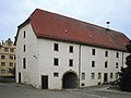
The complex consists of a three-part, baroque -style residential building with farm buildings, cellars, gatehouse and towers that are surrounded by walls and moats . Outside the walls there are other, some stately, farm buildings. An underground escape route once connected the castle fountain with the basement of the gate tower .
The complex impresses mainly with its baroque exterior. Since the building was only inhabited by the Teutonic Commons for about 20 years after the last renovations in 1781 , but was then used for military and agricultural purposes for 200 years, there is no pomp inside. Remains of historical wall paintings were only exposed in the knight's hall .
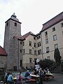
patio

Stair tower

Remnants of wall paintings in the great hall
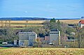
Farm buildings
Heuchlinger Mühle, right next to the castle


literature
- Lothar Hantsch: On the building history of Heuchlingen Castle - the seat of a Teutonic Order Office (around 1500–1806) . In: Bad Friedrichshall 1933–1983 . City of Bad Friedrichshall, Bad Friedrichshall 1983
Web links


Castles: Wasserschloss Adelshofen (dismissed) | Affaltrach Castle | Assumstadt Castle | Babstadt Castle | Bad Rappenau moated castle | Bonfeld Upper Castle | Bonfeld Lower Castle | Brackenheim Castle | Burg Castle | Chanowsky Castle | Domeneck Castle | Eschenau Castle | Fürfeld Castle | Lower Gemmingen Castle | Greckenschloss | Grombach Castle | Heinsheim Castle | Heuchlingen Castle | Horneck Castle | Ittlingen Castle | Jagsthausen Red Castle | White Jagsthausen Castle | Teutonic Order Castle Kirchhausen | Neippergsches Schloss Klingenberg | Kochersteinsfeld Castle (exited) | Upper Castle (Lauffen am Neckar) | → Lautenbach Castle | Wasserschloss Lautereck | Lehen Castle | Lehrensteinsfeld Castle | Liebenstein Castle | Magenheim Castle | Massenbach Castle | Neues Schlösschen (Michelbach am Heuchelberg) | Teutonic Order Castle Neckarsulm | Neudenau Castle | Neuenstadt Castle | Obergimpern Castle | Oedheim Castle | Presteneck Castle | Rohrbach Castle | Schomberg Castle | Schwaigern Castle | Siegelsbach Castle | St. André's Castle | Stocksberg Castle | Upper Talheim Palace | Lower Talheim Palace | Trappenseeschlösschen | Treschklingen Castle | Weiler Castle | Gemmingensches Schloss Widdern | Zaberfeld Castle
Castles and ruins: Alte Bürg (Möckmühl) (removed) | Blankenhorn castle ruins | Duttenberg Castle | Ehrenberg Castle (Neckar) | Ehrenberg Castle (Talheim) (dismissed) | Erenstein Castle (exited) | Harchenburg (Old Castle) (exited) | Helfenberg castle ruins | Heriboldesburg castle ruins | Hohenbeilstein Castle | Horkheim Castle | Götzenburg Jagsthausen | Korb Castle (exited) | Alte Burg (Lauffen am Neckar) (removed) | Count Castle | Leinburg (departed) | Löwenstein Castle ruins | Maienfels Castle | Möckmühl Castle | Neipperg Castle | Ochsenburg Castle | → Obermagenheim Castle (exited) | Ringwall Ottilienberg | Richen Castle (exited) | Stettenfels Castle | Streichenberg Castle | Castle ruin Weibertreu | Widdern Castle (exited) | Wildeck Castle | Kaiserpfalz Wimpfen am Berg
Coordinates: 49 ° 15 ′ 6.2 " N , 9 ° 12 ′ 52.3" E