Schwalefeld
|
Schwalefeld
Municipality Willingen (Upland)
Coordinates: 51 ° 18 '26 " N , 8 ° 37' 48" E
|
|
|---|---|
| Height : | 512 m above sea level NHN |
| Area : | 8.35 km² |
| Residents : | 579 (Jan. 18, 2018) |
| Population density : | 69 inhabitants / km² |
| Incorporation : | April 1, 1972 |
| Incorporated into: | Willingen |
| Postal code : | 34508 |
| Area code : | 05632 |
|
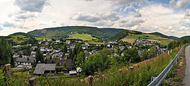
Panoramic view from the east over Schwalefeld
|
|
Schwalefeld is a district of the municipality of Willingen (Upland) in the northern Hessian district of Waldeck-Frankenberg .
The village, which is also known as the “mother of the upland ” because of its geographical location and old castle ruins , is a winter sports area and climatic health resort .
Geographical location
Schwalefeld is located in the Diemelsee Nature Park 2 km northeast of the Willingen core town and 1.3 km (as the crow flies ) west-southwest of Rattlar . The place is located at 520 to 807 m above sea level. NN and is traversed in a south-north direction by the Itter tributary Aarbach .
history
In the 8th / 10th In the 19th century, a ring wall was built on the Hegeberg, the Schwalenburg , the origin of which is still unknown today. The castle complex is first mentioned in the land register from 1537 as a castle of no small size. Other sources speak of an Old Saxon castle that could have been destroyed by the Franks at the time of Charlemagne .
The place is first mentioned in 1333. 1464 invested Graf Wolrad II. A Henry of Immichusen with hooves country. In 1497 a desolation "Lüttiden Schwalefeld" is mentioned, from 1537 this was a fief of the Lords of Viermünden . In 1537 the whole village belongs to the Counts of Waldeck.
It was long assumed that it was first mentioned around 1380. In 2008, based on the year 1333, the 675th anniversary was celebrated.
On April 1, 1972, Schwalefeld and Rattlar were incorporated into the municipality of Willingen as part of the regional reform in Hesse . This was again powerful state law on 1 January 1974 with the municipality of Upland for greater community Willingen (Upland) together . Local districts were formed for all former municipalities . Willingen became the seat of the municipal administration.
societies
- Gymnastics and Sports Club Schwalefeld e. V., founded in 1921
- Voluntary fire brigade , founded in 1934
- Schwalefeld tourist office, founded in 1936
- Schützenverein Schwalefeld e. V., founded 1974 (formerly war club, founded 1880)
- Choral society Eintracht Schwalefeld, founded in 1896
- Schwalefeld tennis club, founded in 1976
Economy and Infrastructure
Economic structure
Schwalefeld is still very rural. The climatic health resort has a grocery store and several leisure activities and restaurants.
Public facilities
- Evangelical kindergarten
tourism
Numerous hotels, guest houses and holiday apartments offer overnight accommodation for guests. There are hiking trails in the area that lead through the forests of the Aar Valley. Willingen is three kilometers away with other leisure activities. There is also a mountain bike course and a playground, the "garden of relaxation". Concerts are offered to guests on the Kurplatz on summer days.
Personalities
- Jochen Behle (* 1960), former cross-country skier and national trainer in cross-country skiing, lives in Schwalefeld
- Stephan Leyhe (* 1992), active ski jumper, born in Schwalefeld
- Stephanie Müller (* 1985), former biathlete
literature
- Helmut Göbel: Schwalefeld . Arolsen: Waldeckischer Geschichtsverein 1987 (= Waldeckische Ortssippenbücher 32); Covered period 1644–1986, 690 families
- Literature about Schwalefeld in the Hessian Bibliography
Web links
- Schwalefeld district. In: Website of the municipality of Willingen (Upland).
- Schwalefeld, Waldeck-Frankenberg district. Historical local dictionary for Hessen. In: Landesgeschichtliches Informationssystem Hessen (LAGIS).
Individual evidence
- ↑ Landmark areas. In: Internet presence. Willingen municipality (Upland), archived from the original on November 4, 2018 ; accessed in November 2018 .
- ↑ Population of the districts. In: Internet presence. Municipality of Willingen (Upland), archived from the original on 20181102 ; accessed in November 2018 .
- ↑ Louis Curtze - History of the Principality of Waldeck , p. 644
- ^ JA Varnhagen - History of the Principality , p. 52
- ↑ Louis Curtze - History of the Principality of Waldeck , p. 643
- ↑ Law on the reorganization of the districts of Frankenberg and Waldeck (GVBl. II 330-23) of October 4, 1973 . In: The Hessian Minister of the Interior (ed.): Law and Ordinance Gazette for the State of Hesse . 1973 No. 25 , p. 359 , § 3 ( online at the information system of the Hessian state parliament [PDF; 2,3 MB ]).
- ^ Federal Statistical Office (ed.): Historical municipality directory for the Federal Republic of Germany. Name, border and key number changes in municipalities, counties and administrative districts from May 27, 1970 to December 31, 1982 . W. Kohlhammer, Stuttgart / Mainz 1983, ISBN 3-17-003263-1 , p. 409 .

