Tŕnie
| Tŕnie | ||
|---|---|---|
| coat of arms | map | |

|
|
|
| Basic data | ||
| State : | Slovakia | |
| Kraj : | Banskobystrický kraj | |
| Okres : | Zvolen | |
| Region : | Pohrony | |
| Area : | 12.290 km² | |
| Residents : | 422 (Dec. 31, 2019) | |
| Population density : | 34 inhabitants per km² | |
| Height : | 516 m nm | |
| Postal code : | 962 34 | |
| Telephone code : | 0 45 | |
| Geographic location : | 48 ° 36 ' N , 19 ° 2' E | |
| License plate : | ZV | |
| Kód obce : | 518875 | |
| structure | ||
| Community type : | local community | |
| Structure of the municipality: | 3 cadastral communities | |
| Administration (as of November 2018) | ||
| Mayor : | Martina Kubincová | |
| Address: | Obecný úrad Tŕnie č. 97 962 34 Tŕnie |
|
| Website: | www.trnie.sk | |
| Statistics information on statistics.sk | ||
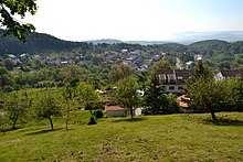
Tŕnie (until 1973 Slovak "Trnie"; Hungarian Zólyomternye - until 1907 Ternye ) is a municipality in central Slovakia with 422 inhabitants (as of December 31, 2019) and belongs to Okres Zvolen , a district of Banskobystrický kraj .
geography
The village is located in the Kremnica Mountains in the valley of a tributary of the Turová brook . Nearby occur Andesitgestein and pyroclastic sediments. The center of the village lies at an altitude of 516 m nm and is 13 kilometers from Zvolen .
Administratively, the municipality consists of the cadastral communities Tŕnie (main town), Budička and Kašova Lehôtka (both incorporated in 1925).
Neighboring municipalities are Sliač (district Hájniky ) in the north, Turová in the east, Budča in the south, Hronská Dúbrava in the southwest and Železná Breznica in the west
history
Tŕnie probably originated in the second half of the 14th century and was first mentioned in writing in 1393 as Thirna . At that time the village belonged to the rulership of Sohl. In 1828 there were 32 houses and 240 inhabitants who were employed as farmers.
Budička was first mentioned in writing in 1533 and was then owned by the Ostrolúcky family . In 1828 there were nine houses and 70 residents who were employed as farmers and cattle herders.
Kašova Lehôtka was created in the 14th century. The residents were employed as farmers and forest workers.
Until 1918, the places in Sohl County belonged to the Kingdom of Hungary and then came to Czechoslovakia or now Slovakia. In 1928 half of Tŕnie burned out.
population
According to the 2011 census, Tŕnie had 430 inhabitants, including 388 Slovaks , two Magyars and one German . 39 residents did not provide any information on ethnicity .
319 residents committed to the Roman Catholic Church, seven residents to the Evangelical Church AB and one resident each to the Greek Catholic Church and the Czechoslovak Hussite Church; one resident professed a different denomination. 56 inhabitants had no denomination and the denomination of 45 inhabitants was not determined.
Buildings
- Roman Catholic Martinskirche in Tŕnie from the 14th century, originally redesigned in 1695 and 1726 in the Renaissance or Baroque style and supplemented with the tower
- One wooden bell tower each in Budička and Kašova Lehôtka from the early 20th century
- four listed houses in the typical regional architectural style in Kašova Lehôtka
Individual evidence
- ↑ Slovenské slovníky: názvy obcí Slovenskej republiky (Majtán 1998)
- ↑ Results of the 2011 census (Slovak)
Web links
- Entry on e-obce.sk (Slovak)


