Sása (Zvolen)
| Sása | ||
|---|---|---|
| coat of arms | map | |

|
|
|
| Basic data | ||
| State : | Slovakia | |
| Kraj : | Banskobystrický kraj | |
| Okres : | Zvolen | |
| Region : | Pohrony | |
| Area : | 24.671 km² | |
| Residents : | 927 (Dec. 31, 2019) | |
| Population density : | 38 inhabitants per km² | |
| Height : | 383 m nm | |
| Postal code : | 962 62 | |
| Telephone code : | 0 45 | |
| Geographic location : | 48 ° 26 ' N , 19 ° 8' E | |
| License plate : | ZV | |
| Kód obce : | 518727 | |
| structure | ||
| Community type : | local community | |
| Administration (as of November 2018) | ||
| Mayor : | Iveta Hladká | |
| Address: | Obecný úrad Sása Námestie SNP 329/1 962 62 Sása |
|
| Website: | www.sasa.sk | |
| Statistics information on statistics.sk | ||
Sása (German: Deutschpleißen , Hungarian : Szászpelsőc - until 1888 Szász ) is a municipality in central Slovakia with 927 inhabitants (as of December 31, 2019) and belongs to the Okres Zvolen , a district of the Banskobystrický kraj .
geography
The municipality is located in the small valley basin Pliešovská kotlina on the Neresnica river ( Hron catchment area ), in the northeast of the municipality it has a share of the Javorie Mountains . The center of the village is at an altitude of 383 m nm and is 21 kilometers from Zvolen .
Neighboring municipalities are Dobrá Niva in the north, Zvolen in the northeast, Pliešovce in the northeast and east, Bzovská Lehôtka in the south, Krupina in the southwest and Babiná in the west.
history
Sása was first mentioned in writing as Sasca in 1332 ; other historical names are Nemet Pelseucz (1351), Pelsewlch (1393) and Nemethpelseuch (1410). Related to the name is the original German population who came from Saxony. Until 1351 the village belonged to the estate of Döbring Castle in nearby Dobrá Niva; in the same year it received city rights.
During the Turkish Wars there was a small anti-Turkish fortress here, where 50 men were stationed. Nevertheless, the town had to pay tribute to the Ottoman Empire . After a heavy pillage by the Turks in 1644, Sása lost the character of a town and became a simple agricultural community. In 1828 there were 85 inhabitants and 625 inhabitants who were employed in agriculture and as craftsmen.
Until 1918 the place in Sohl County belonged to the Kingdom of Hungary and then came to Czechoslovakia or today Slovakia.
population
According to the 2011 census, 951 people lived in Sása, including 878 Slovaks, 26 Roma, three Czechs and two Magyars. 42 residents gave no information in this regard. 469 residents committed themselves to the Roman Catholic Church, 313 residents to the Evangelical Church AB and one resident each to the Greek Catholic Church, the Orthodox Church and the Reformed Church; one resident professed a different denomination. 87 inhabitants had no denomination and the denomination of 78 inhabitants was not determined.
Buildings
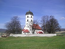
- fortified Roman Catholic Katharinenkirche from the 13th century, predominantly in the Romanesque style with Gothic traces
- Protestant church from 1894
Individual evidence
- ↑ 2011 census by ethnicity (Slovak) ( Memento from October 6, 2014 in the Internet Archive )
- ↑ 2011 census by denomination (Slovak) ( Memento from September 7, 2012 in the Internet Archive )
Web links
- Entry on e-obce.sk (Slovak)

