
Treskowallee
| Treskowallee | |
|---|---|
|
|
|
 |
|
| Central area of Treskowallee at the blue hour |
|
| Basic data | |
| place | Berlin |
| District | Karlshorst |
| Created | before the 18th century |
| Hist. Names |
Road to Cöpenick (until 1900) , Hermann-Duncker-Strasse (1961–1992) |
| Connecting roads |
Am Tierpark (north) , Edisonstrasse (south) |
| Cross streets | see adjacent drawing |
| use | |
| User groups | Pedestrian traffic , bicycle traffic , car traffic , public transport |
| Technical specifications | |
| Street length | 3150 meters |
The Treskowallee is a busy street in the Berlin districts Lichtenberg and Treptow-Koepenick . It is considered to be the main line in the district of Berlin-Karlshorst , around which the Vorwerk developed first and the Colonie developed at the end of the 19th century . The Berlin list of monuments contains around 50 monuments in the catchment area of Treskowallee.
Location and naming of the street

The name range of Treskowallee that is valid today concerns part of the road to Cöpenick, which was already in use in the 18th century . In the 19th century, this was also called Kreis-Chaussee because it was in the Niederbarnim district . The name Treskowallee was first used from 1900 onwards, namely for the area between the entrance to the Friedrichsfelde Palace Park and the Hohen Wallgraben at the south entrance of today's Karlshorst trotting track . The street was named after Carl von Treskow , the owner of the manor and Schloss Friedrichsfelde.
On July 15, 1961, Treskowallee was divided into two sections that were given different names. The northern part from the castle park entrance to the district boundary between Friedrichsfelde and Karlshorst at the underpass of the VnK (connection to Kaulsdorf) route was combined with the castle street adjoining to the north to form Am Tierpark street .
The remaining part of Treskowallee was named Hermann-Duncker-Straße on the same day after Hermann Duncker , the rector of the trade union college "Fritz Heckert" who had died a year earlier . The Karlshorster Landstrasse in the south , in the Oberschöneweide district , was included in the new name, so the road was extended by a section of around 1.6 kilometers. Hermann-Duncker-Strasse now extended from the railway bridge at the Tierpark to the intersection with Rummelsburger Strasse / An der Wuhlheide. The properties along the entire street have been renumbered accordingly.
After German reunification , the Lichtenberg district office renamed the entire Hermann-Duncker-Strasse to Treskowallee in 1992. The exact location can be seen on the map.
The geographic coordinates refer to Treskowallee at Berlin-Karlshorst train station , which is about halfway along the street.
The numbering of Treskowallee begins at its northern starting point, with the even numbers on the western side and the odd numbers on the eastern side. The southern end of Treskowallee is number 240.

Brief description of different sections of Treskowallee
Northern section to Hönower Straße
-
Numbers 8–12: Berlin University of Technology and Economics , inaugurated in 1914 as a double building for a grammar school and a lyceum ; in the inner courtyard the “ Auditorium maximum ” and memorial for Nikos Belogiannis (a Greek freedom fighter executed in 1952 ) by René Graetz ; a bronze Lynx family , 1978 by Lothar Rechtacek designed, stands in the meadow.
The subsequent section of the street, on which a student dormitory was built in the 1950s, was built on in 2013-2015. Here the Howoge had the Treskow Höfe built as part of a new building initiative . On the area on the corner of Römerweg, which had been cleared except for a few parts of the building, archaeologists were able to carry out excavations before construction began. Remnants of a Bronze Age settlement came to light. The foundation stone for the Treskow-Höfe, in which 400 apartments are planned, was laid on September 11, 2013 in the presence of the Governing Mayor of Berlin , Klaus Wowereit , the then Senator for Urban Development Michael Müller , the then Lichtenberg Mayor Andreas Geisel and the management of Howoge . - Number 30: Here is one of Berlin's numerous Buddy Bears .
- Numbers 39–47: As "Houses of the best hospitality, Lichtenberg district" on the occasion of the III. World Festival of Youth and Students honored with a plaque in 1951.
Middle section from Hönower Straße to Karlshorst train station

This area begins on Hönower Straße, where there is a striking yellow building (No. 26) that housed the Chinese embassy until the early 1970s, then the Mexican embassy until the late 1970s and the Libyan embassy from the mid-1980s to 1990 the GDR housed.
The entire central area of Treskowallee and its side streets had to be cleared for members of the Soviet army from May 3, 1945 , and all around 8,000 residents had to leave their homes within 24 hours. The large area was cordoned off with fences and barriers and could only be entered with special permission. Only Treskowallee remained free for through traffic including the tram (line 69). In the following years, the restricted area was gradually reduced in size and the fences were put out of sight. When food cards were still needed for daily shopping in East Berlin , those in the know were able to buy inexpensive and brand-free in the area mentioned in the “ Russenmagazin ”. It was not until May 1963 that the restricted area on Treskowallee disappeared completely.
- Number 112: Kulturhaus Karlshorst
- Number 115 at the corner of Stolzenfelsstrasse: listed historic Karlshorst station building .

Former Libyan embassy in the GDR

Southern section from Karlshorst train station to An der Wuhlheide


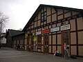
- Number 114 : former station building of the Karlshorst racing station opened in 1894 (under monument protection). As a terminal station with seven tracks, five of which still exist today, it served as a special train station for the Karlshorst racecourse. Passenger traffic ceased after 1929. The half-timbered building was retained and the building served the railway in other functions until 1993. A supermarket used the building from 1998 to 2012. In June 2018, the Bio Company opened an organic supermarket on the premises.
- in front of the former racing station : Monument to Hermann Duncker by Walter Howard , erected here in 1976 (monument protection), for which the sculpture of a female nude by Karl Trumpf was moved to a park on Ingelheimer Strasse.
- Number 115 : The house housed the Vorwärts cinema, built in 1930 under the name Capitol . It was demolished in 2001 despite public protests. The property was rebuilt in 2017 with an apartment house named after Johann Christian Ludwig Hellwig .
- Number 116 : Neo-Baroque building with stucco ornaments in Art Nouveau style (under monument protection)
- Numbers 129–137 : Karlshorst trotting track . It is included in the Berlin list of monuments with all parts such as the reception building, grandstand, scale building, equestrian statue from 1925 by Willibald Fritsch and others.
- Number 176 : The district boundary to Oberschöneweide is at the level of this property number .
- Numbers 210–220 : The former Queen Elisabeth Hospital was used as a hospital by the Soviet Army between 1945 and 1991 . After the troops withdrew, the wing to Treskowallee was empty for many years. In 2011, one of these now completely renovated and modernized buildings was reopened as Haus Elisabeth of the Diakoniewerk Simeon. It offers accommodation to 124 people in need of care.
- Number 222 : Albatros School (special school for the mentally handicapped), was set up in the rear wing of the building, which used to belong to the Queen Elisabeth Hospital, after its renovation
Between the southern end of the Trabrennbahn and the Volkspark Wuhlheide there was a large -panel housing estate built in the 1970s for the families of the officers of the Soviet Army. The buildings were demolished by the end of the 1990s, and the area came into the ownership of the Berlin-Karlshorst e. V.
In the very southern area, parts of the Volkspark Wuhlheide border the Treskowallee, there are sports and playgrounds, a sunbathing lawn, the Wuhlheide summer pool and walking paths. The Berlin-Brandenburg model park can be reached via a footpath .
Former racing station

Trabrennbahn (entrance)

Former Queen Elisabeth Hospital, Albatros School


traffic
The entire Treskowallee is used by three tram lines (M17, 27 and 37); another tram line (21) and two bus lines (296 and 396) open up the surrounding living area. The tram line was opened on May 1, 1910 as the third line of the Berlin Eastern Railways .
A traffic census carried out in 2005 showed 37,200 vehicles that pass Treskowallee in both directions every day. An estimated increased traffic volume of a further 600 vehicles per day is expected with the completion of the new Berlin Brandenburg Airport .
In order to reduce through traffic on the main roads running in north-south direction in the eastern part of Berlin (including Treskowallee), the construction of the middle section of the Tangentialenverbindungen East (TVO) from Märkische Allee in Biesdorf to street An is necessary in the medium term the Wuhlheide in Oberschöneweide .
About half the length of Treskowallee is the Berlin-Karlshorst train station , where the S-Bahn line S3 ( Berlin-Spandau - Erkner ) stops. From 1961 to the end of 2017, Karlshorst was also a stop for regional trains.

The extension of the bridge over Treskowallee by Deutsche Bahn (DB ProjektBau GmbH and DB Netz AG) started in 2012 and will result in the underpass being built over two lanes in each direction and a tram route with a total width of 31 Meters. The tram tracks under the bridge will be relocated to the sidewalk to make it easier to change to the S-Bahn. However, completion is not expected before 2020. On the eastern side of the street, the historic access to the S-Bahn station under the bridge has been reopened. On the western side of the street, a pedestrian walkway with elevator and staircase was opened in early 2015 as an extension of the S-Bahn platform.
economy
The university for technology and economics , finance companies, engineering offices, the Karlshorster branch of the music school Lichtenberg , small-scale trading companies and restaurants form the infrastructure of the street.
Groundwater protection
Treskowallee borders the water protection area V (Wuhlheide / Kaulsdorf) of the city of Berlin as follows :
"Down the river to the branch canal at the Klingenberg thermal power station, along the branch canal and from there on a line to Wallensteinstraße, further along the embankment to the end of the allotment garden facilities, on the border of the allotment garden colony, following the Römerweg to Treskowallee, further on Treskowallee, the Brascheweg, the Robert-Siewert-Strasse, the Ursula-Goetze-Strasse to the north to the embankment foot [...] "
It has the following limits with the water protection area IIIa :
“[...] continue along Blockdammweg, Ehrlichstraße, Trautenauer Straße, on the north side of the Seepark, on Traberweg to Treskowallee, on this further north to Stolzenfelsstraße, along Stolzenfelsstraße, along Loreleystraße, from here on one line to the east which cannot be specified in detail. "
literature
- The Dahlem of the East - Karlshorst and its villa colony . From Jan Feustel: Walks in Lichtenberg , Haude and Spener Berlin 1996, ISBN 3-7759-0409-3 .
- The architectural and art monuments in the GDR, capital Berlin II . Ed. Institute for Monument Preservation, Henschelverlag, Berlin 1987, pages 227–241; ISBN 3-362-00138-6 .
- Joachim Schulz and Werner Gräbner: Architectural Guide GDR, Berlin . Verlag für Bauwesen, Berlin, 2nd edition 1976.
Web links
-
Treskowallee. In: Street name lexicon of the Luisenstädtischer Bildungsverein (near Kaupert )
- Karlshorster Chaussee . In: Luise.
- Karlshorster Landstrasse . In: Luise.
- Hermann-Duncker-Strasse . In: Luise.
Individual evidence
- ↑ List of monuments for Berlin-Lichtenberg starting on page 214 ( Memento of the original from September 11, 2011 in the Internet Archive ) Info: The archive link was inserted automatically and has not yet been checked. Please check the original and archive link according to the instructions and then remove this notice. (PDF; 2.2 MB) at the Senate Department for Urban Development
- ^ Homepage of HTW Berlin - Treskowallee campus
- ↑ Birgit Eltzel: Decorated shards from the Bronze Age. In: Berliner Zeitung , September 24, 2013; Retrieved October 28, 2013.
- ↑ Laying of the foundation stone for the Treskow-Höfe Karlshorst . In: Rathausnachrichten , October 5, 2013, p. 5.
- ↑ Karlshorst S-Bahn station (Berlin monument database)
- ↑ Monument complex Rennbahnhof Karlshorst
- ↑ Monument to Hermann Duncker
- ↑ Mathias Raabe: By the end of February the “forward” will be gone . In: Berliner Zeitung . January 9, 2001 ( berliner-zeitung.del ).
- ^ Website of GBI AG Erlangen on the new business building
- ↑ Monument Treskowallee 116
- ^ Homepage of the house of Elisabeth
- ↑ Architecture Guide GDR, Berlin , p. 138
- ^ Wolfgang Kramer, Siegfried Münzinger: The company for the construction of underground railways GmbH - Berliner Ostbahnen . In: Berliner Verkehrsblätter . Issue 7, 1962, pp. 56 .
- ↑ The road under the Karlshorst bridge will not be finished before 2020. In: Berliner Woche , May 20, 2015
- ↑ Pedestrian bridge at the S-Bahn station open . In: Berlin Week . Edition Lichtenberg, March 12, 2015
- ↑ The new pedestrian bridge at Karlshorst station on bahnbilder.de
- ^ Extract from the Berlin Water Act in the amendments made in 1999
Coordinates: 52 ° 28 ′ 54 ″ N , 13 ° 31 ′ 31 ″ E