
Truper Blänken
| Truper Blänken | ||
|---|---|---|

|
||
| The lake around 1764 | ||
| Geographical location | Lilienthal , Osterholz district , Lower Saxony | |
| Location close to the shore | Bremen | |
| Data | ||
| Coordinates | 53 ° 9 '16 " N , 8 ° 52' 20" E | |
|
||
|
particularities |
Reclaimed former lake |
|

The Truper Blänken (also outdated Trüper Blenken ) was a large shallow water lake in the eastern part of the marsh meadows of St. Juergensland with an area of at times over 100 hectares . It was north of the Wümme meander and the Bremen blockland in the districts of Lilienthal and St. Jürgen in the Lilienthal community in what is now the Osterholz district in Lower Saxony .
description
The lake was fed and flowed through by the Alten Wörpe coming from the northeast , which a little later flowed into the Wümme. In the 18th century the Alte Wörpe was separated from the current lower course of the river, which was then laid through the center of Lilienthal. From the 1930s onwards, the expansion of the Weser , the construction of pumping stations and numerous other extensive melioration measures enabled the Truper Blänken to be gradually drained. This was finally completed in the 1960s.
Since then, large parts of the area have been taken for agricultural use. Except for a few still water areas, there are no longer any larger open water points. Nowadays, the area differs from its immediate surroundings mainly through its irregular structure and a comparatively thin network of drainage ditches . In addition, there are some small forest areas - an extremely rare landscape in the otherwise flat and treeless alluvial land.
Nature reserve
With an ordinance of December 19, 1989, the district government of Lüneburg declared an area of 214 hectares to be the Truper Blänken nature reserve . The area extends west of the village of Lilienthal and belongs to the natural space region of the mud flats and marshes. It bears the statistical code "NSG LÜ 179" and is located in FFH area 33 Untere Wümmeniederung, lower Hammeniederung with Teufelsmoor , which in turn lies entirely within the previously designated landscape protection area of the same name.
According to the Lüneburg district government, it was placed under protection “for the preservation and development of the special character of a wide valley with its characteristic biotope types and plant and animal species”. The still waters and slowly flowing waters, the reed beds and reeds , the alder forests and the wet grassland areas are to be preserved and developed .
Since the Wörpelauf is cut off, floods no longer reach the Blänken. Short-term overflows are still possible due to the inflows from the trenches. In the flood channels that were formerly formed by the Wörpe, reed beds and quarry forests have developed. In addition, ditches and wide canals characterize the open landscape. In the agriculturally unused areas, there are swampy forests of alder , willow and birch, as well as sedge and reed beds, various rich flowering perennials. Water lilies , crab claws and water feathers can be found in the ditches, canals and ponds, and the marsh marigold among others in the more humid areas . The Lower Saxony State Agency for Water Management, Coastal Protection and Nature Conservation judged that the moisture-dependent tree populations would form a mosaic-like structure with the wet grassland and water biotopes. Typical meadow birds such as curlews , lapwing and snipe live in the grassland areas of the nature reserve. In the bushy sections, whinchat , field swirly and goldhamers can be seen among others . Animals tied to the water such as dragonflies and amphibians find their habitat in the nature reserve as well as a species-rich fauna of butterflies and grasshoppers. Of these, the golden insect , the swamp insect and the mole cricket should be mentioned in particular . Together with the adjacent protected areas, the Truper Blänken are also important as a habitat for the otter .
Historical maps
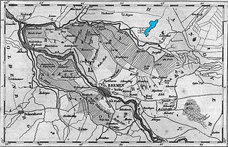
The lake (colored blue to emphasize it) around 1837. The separated tributary Alte Wörpe can be clearly seen to the northeast of it.

The lake in the 1940s


See also
Web links
- Nature reserve "Truper Blänken" in the database of the Lower Saxony State Office for Water Management, Coastal and Nature Conservation (NLWKN)
- "Truper Blänken" nature reserve , brochure of the Lüneburg district government, 1998 (PDF, 2.4 MB)
- Ground breeder in the wet meadows , NABU Lilienthal / Grasberg (PDF, 1.1 MB)
- Historical overview by the Landschaftsverband Stade
Individual evidence
- ↑ a b Information brochure of the former Lüneburg district government, 1998.
- ↑ Specification of the NLWKN in the profile of the nature reserve ( Memento of the original from June 14, 2010 in the Internet Archive ) Info: The archive link has been inserted automatically and has not yet been checked. Please check the original and archive link according to the instructions and then remove this notice.
- ↑ See § 3 Paragraphs 1 and 2 of the ordinance on the “Truper Blänken” nature reserve of December 19, 1989
- ↑ Nature reserves , Osterholz district.


Broad water | Brundorfer Moor | Hammeniederung | Heerweger Moor and source areas of the Ritterhuder Beeke | Heath and moor near Haslah | Heidhofer ponds | Heilsmoor | Moor near Niedersandhausen | Upper Ihlen lowlands | Pennigbütteler Moor | Source valleys of the Wienbeck | Springmoor | Teufelsmoor | Tideweser | Peat canal and bogs | Truper Blänken | Lower Wümme | Western half of the Long Moor | Meadows and pastures northeast of the Breite Wasser