
Twardogóra
| Twardogóra | |||
|---|---|---|---|

|
|
||
| Basic data | |||
| State : | Poland | ||
| Voivodeship : | Lower Silesia | ||
| Powiat : | Oleśnica | ||
| Area : | 8.29 km² | ||
| Geographic location : | 51 ° 22 ′ N , 17 ° 28 ′ E | ||
| Height : | 190 m npm | ||
| Residents : | 6692 (Jun. 30, 2019) |
||
| Postal code : | 56-416 | ||
| Telephone code : | (+48) 71 | ||
| License plate : | DOL | ||
| Economy and Transport | |||
| Street : | Syców - Milicz | ||
| Rail route : | Ostrow – Großgraben | ||
| Oels-Jarotschin | |||
| Next international airport : | Wroclaw | ||
| Gmina | |||
| Gminatype: | Urban and rural municipality | ||
| Gmina structure: | 19 districts | ||
| Surface: | 167.99 km² | ||
| Residents: | 13.008 (Jun. 30, 2019) |
||
| Population density : | 77 inhabitants / km² | ||
| Community number ( GUS ): | 0214083 | ||
| Administration (as of 2015) | |||
| Mayor : | Zbigniew Potyrała | ||
| Address: | ul.Ratuszowa 14 56-416 Twardogóra |
||
| Website : | www.twardogora.pl | ||

Twardogóra [ tfardɔ'gura ] ( German Festenberg ) is a town in the powiat Oleśnicki ( Oelser District ) in the Polish Voivodeship of Lower Silesia . The city with almost 7,000 inhabitants is the capital of a city and rural community with around 13,000 inhabitants.
Geographical location

The city is located in Lower Silesia on the northern slope of the Katzengebirge , about 18 kilometers northwest of Syców ( Groß Wartenberg ) and 40 kilometers northeast of Wroclaw . There are numerous boulders in the hilly landscape . The municipality has a share in the Grabowno Wielkie moorland ("Rezerwat torfowisko koło Grabowna Wielkiego"), in the north in the Bartschbruch Landscape Park ("Park Krajobrazowy Dolina Baryczy") and 45% of it is covered by forests.
history
_ID_596478.jpg)
Today's Twardogóra emerged as a market town on a trade route from Wroclaw to Poznan . Vestenberg was first mentioned in a document when it was on September 1, 1293 by Duke Heinrich III. von Glogau received the Neumarkt city charter. Since the 14th century Festenberg belonged to the Duchy of Oels , which in 1329 was subordinated to the Crown of Bohemia as a fief , which was confirmed by the Treaty of Trenčín in 1335 . After the city suffered during the Hussite Wars (1432–1434), the residents built a defensive structure towards the end of the 15th century that was supposed to protect the city from further destruction and was replaced by a castle 100 years later. Even if Festenberg fell to the Catholic Habsburgs with the Duchy of Oels in 1526 , the sovereign Karl I of Münsterberg carried out the secularization of Catholic church property in the Duchy of Oels . His sons continued his work and introduced the Reformation in 1538 .
Festenberg experienced its first heyday under the Württemberg people , who took over the duchy in 1647. Eleonore , the wife of Duke Sylvius Friedrich I , made a special contribution to the further development and expansion of Festenberg. With the upper ring she had a second market square with the Protestant church Zum Kripplein Christi built and the Festenberg castle redesigned into a baroque castle, so that Festenberg only took on urban character at that time. In addition, the city was exempt from all taxes for 100 years.
At that time, cloth-making developed into Festenberg's most important line of business. The Festenberg Jews, who had fled Poland since the 17th century and settled in the city, were particularly active in this trade. In Festenberg they owned a school and an old cemetery on the so-called Judenberg, which was leveled after the Second World War. Festenberg came to Prussia in 1740 and 1742, and was soon bought by Count Heinrich Reichenbach in 1743, and in 1744 it became part of his new estate, Goschütz . In the middle of the 19th century, the cloth industry experienced a decline due to a lack of water and the migration of most of the craftsmen to the new, large textile industrial areas, especially in and around Lodz .
As a substitute, however, the wood processing industry developed into the main branch of the economy, which is why Festenberg was later given the popular nickname “Carpenter's Town”. In the 19th century, the urban development expanded more and more, so that two new cemeteries for the Catholic and Protestant congregations outside the city were created instead of the earlier inner-city cemeteries. As the economy progressed, a water pipe was laid in 1901, the city was electrified in 1910 and in 1908 it was connected to the railway network. This development was also expressed by new institutions such as a bank, a printing company, the district court including prison and the town hall on the Ring, which were built in Festenberg before the First World War . The urban area of Festenberg expanded in 1908 and 1912 as the entire manor district Alt Festenberg and in 1910, when the rural community Alt Festenberg (1895: 668 inhabitants) was incorporated.
In 1945 the city of Festenberg belonged to the district of Groß Wartenberg in the administrative district of Breslau in the Prussian province of Silesia of the German Empire .
On January 23, 1945 the city was occupied by the Red Army and was under Polish administration after the war . Festenberg was then officially renamed Twardogóra , a variant of the previously historically used Polish name "Twardagora". In the period that followed, the German residents were expelled from Festenberg by the local Polish administrative authorities . In 1947, the Reichenbachsche Baroque castle was in what is now the district Goszcz ( Goschütz burned) after the end of the Second World War the previously hard Berger castle had been looted.

Population development
| year | Residents | Remarks |
|---|---|---|
| 1786 | 1,175 | |
| 1875 | 2.153 | |
| 1880 | 2.211 | |
| 1885 | 2,201 | |
| 1890 | 2,335 | of which 1,907 Protestants, 382 Catholics and 46 Jews |
| 1900 | 2,315 | mostly evangelicals |
| 1910 | 3,350 | on December 1st, Alt Festenberg manor district: 141 inhabitants |
| 1925 | 3,385 | |
| 1933 | 3,805 | |
| 1939 | 3,870 | |
| 1944 | ~ 4,500 | |
| 1969 | 4,200 | |
| 2004 | 6,869 | On the 31st of December |
| 2005 | 6,905 | On the 31st of December |
Attractions
- The baroque castle dates back to a fortification from the 14th century and was built in its present form in the 18th century, including the castle park. In the park there is a baroque statue of Hercules that comes from the devastated Goschütz Castle.
- Numerous houses from the 18th and 19th centuries can still be found on Festenberger Ring . Century and the courthouse from 1902, which now houses the town hall.
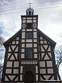
- The Evangelical Church of the Holy Trinity and St. Mary probably dates from the first half of the 16th century. The first pastor was hired in 1592 and an independent parish was founded around 1610. Soon afterwards the church was replaced by a new wooden building, which served as a branch church from 1690, when a second Evangelical church followed in the city. In 1725 the church was renovated due to its dilapidation and rebuilt from 1877 to 1879 in its current rectangular shape as a neo - Gothic half - timbered building . The baroque furnishings of the previous building were taken over. Until 1945 the church was used as a chapel, since then it has not been used due to the lack of a Protestant parish.
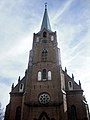
- The Catholic Maria-Hilf-Kirche ( kościół parafialny pw. MB Wspomożenia Wiernych ) was built from 1688 to 1690 as the church "Zum Kripplein Christi" on the upper ring and was at that time the second Protestant church in Festenberg. The wooden hall building with two-story galleries on a cross-shaped floor plan became the new parish church and at the same time served as a "border church" for the Protestants of the adjoining Catholic / Habsburg areas of Silesia. In 1873 it fell victim to a fire, whereupon in 1874 a large neo-Gothic brick church was built according to plans by Carl Johann Lüdeckes . The cross-shaped basic structure was taken up again and supplemented by a massive front tower. After 1945 the church was taken over by the Catholic parish, rebuilt and later elevated to the rank of a minor basilica .

Town hall in Festenberg (Lower Silesia)

Town hall in Festenberg (Lower Silesia)
Maria-Hilf Church
BASILICA MINOR


"Peace Be With You"
Church of the Holy Trinity and St. Mary

Church of the Holy Trinity and St. Mary

Church of the Holy Trinity and St. Mary


sons and daughters of the town
- Julius Baron (1834–1898), German legal scholar and university professor
- Ludwig Laqueur (1839–1909), ophthalmologist, pioneer of glaucoma surgery
- Paul von Grützner (1847–1919), physiologist, university professor
- Ruth Goetz , married Ruth von Schüching (1880–1965), writer, journalist and screenwriter
- Heinrich Graf von Reichenbach (* 1928), emeritus professor for soil science at the University of Hanover
- Martin Pohl (1930–2007), German poet and actor
- Hagen Kleinert (* 1941), professor of theoretical physics at the Free University of Berlin
local community
The urban and rural community of Twardogóra with almost 13,000 inhabitants consists of the main town of the same name and the following localities:
|
|
traffic
The city of Twardogóra is located on the Ostrów Wielkopolski – Grabowno Wielkie railway , which joins the Oleśnica – Chojnice railway in the Grabowno Wielkie district .
Web links
- City website
- Website of the Catholic community
- History of the Protestant Congregation (Polish)
- Festenberg . In: Meyers Konversations-Lexikon . 4th edition. Volume 6, Verlag des Bibliographisches Institut, Leipzig / Vienna 1885–1892, p. 174.
Individual evidence
- ↑ a b population. Size and Structure by Territorial Division. As of June 30, 2019. Główny Urząd Statystyczny (GUS) (PDF files; 0.99 MiB), accessed December 24, 2019 .
- ↑ Johann Georg Knie: Alphabetical-statistical-topographical overview of all villages, spots, cities and other places of the royal family. Preuss. Province of Silesia, including the entire Margraviate of Upper Lusatia, which is now part of the province, and the County of Glatz. Breslau: Barth and Comp., 1830., page 922
- ↑ a b c d e f Michael Rademacher: German administrative history from the unification of the empire in 1871 to the reunification in 1990.wartberg.html. (Online material for the dissertation, Osnabrück 2006).
- ^ Meyer's Large Conversational Lexicon . 6th edition, Volume 6, Leipzig / Vienna 1906, p. 465.

Bierutów (Bernstadt ad Weide) | Dobroszyce (Juliusburg) | Dziadowa Kłoda (Kunzendorf) | Międzybórz (Neumittelwald) | Oleśnica (Oels) - city | Gmina Oleśnica | Syców (Groß Wartenberg) | Twardogóra (Festenberg)