
Hochdorf LU
| LU is the abbreviation for the Canton of Lucerne in Switzerland and is used to avoid confusion with other entries in the name Hochdorf . |
| Hochdorf | |
|---|---|
 |
|
| State : |
|
| Canton : |
|
| Constituency : | Hochdorf |
| BFS no. : | 1031 |
| Postal code : |
6280 (Hochdorf) 6280 (Urswil) 6283 (Baldegg) |
| UN / LOCODE : | CH HOC |
| Coordinates : | 664 773 / 224356 |
| Height : | 485 m above sea level M. |
| Height range : | 463-538 m above sea level M. |
| Area : | 9.64 km² |
| Residents: | 9846 (December 31, 2018) |
| Population density : | 1021 inhabitants per km² |
|
Proportion of foreigners : (residents without citizenship ) |
21.9% (December 31, 2,015) |
| Website: | www.hochdorf.ch |
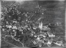
 Hochdorf taken from the northwest |
|
| Location of the municipality | |
  |
|
Hochdorf ( Swiss German Hoofdere [ˈhoːfdərə] ) is a municipality in the Swiss canton of Lucerne . It belongs to the constituency of Hochdorf and is the seat of one of the four Lucerne district courts .
geography
Hochdorf is located in the Lucerne Seetal . The community consists of the districts of Hochdorf-Dorf, Baldegg, Ligschwil, Urswil and numerous groups of houses and individual farmsteads.
The village itself is located on the Lucerne – Lenzburg road around 1 km south-east of Lake Baldegger . In the north of the village, the Junker Forest is one of the few forest areas in the municipality. The Seetaler Ron flows past the western edge of the village.
The district of Ligschwil is 1.5 km south of the village center at 482 m above sea level. M. Just as the southeast lies from him Urswil (2 km south of the village, 495 m above sea level. ) He is from the Seetaler Ron traversed. With the exception of the Wasenwald and small forests (Wirtlenwald, Tannhölzli, Dessenhölzli), the entire municipal area south of the village is an agricultural area.
The municipality northwest of Hochdorf Dorf to Baldeggersee is former marshland. Small remains with a little lake still bear witness to this today. The district of Baldegg, which is a separate village, is located on the south-east bank of Lake Baldegg. It is located 2 km from the center of Hochdorf at 469 m above sea level. M. and is traversed by the Stägbach .
The height differences within the municipality are small. The Baldeggersee is the lowest point in the community at 464 m above sea level. M. The highest point is located on a small hill east of Urswil to 513 m above sea level. M.
Of the 1031 hectares, 960 hectares are land. The rest is the Hochdorf portion of the Baldeggersee. 68.1% of the land area is used for agriculture, while 21.3% is settlement area (houses, streets, etc.). Only 10.7% are covered by forest and wood.
Neighboring communities are Hohenrain , Ballwil , Eschenbach , Rain and Römerswil .
population
| Population development | |
|---|---|
| year | Residents |
| 1798 | 1,041 |
| 1850 | 1,370 |
| 1880 | 1,251 |
| 1888 | 1,277 |
| 1910 | 3,013 |
| 1950 | 3,768 |
| 1960 | 4,452 |
| 1970 | 5'222 |
| 1980 | 6,034 |
| 1990 | 7,055 |
| 2000 | 7,761 |
| 2004 | 7,846 |
| 2006 | 8'050 |
| 2007 | 8'213 |
| 2008 | 8,385 |
| 2013 | 9,101 |
The population grew strongly from 1798 to 1850 (1798–1850: +31.6%). Thereafter it fell slightly until 1880 (1850–1880: −8.7%). With the settlement of industrial companies and the commissioning of the Seetalbahn (Lucerne – Lenzburg), strong growth began (1888–1910: +135.9%). Moderate but steady growth followed up to the middle of the 20th century (1910–1950: + 25.1%). In the second half of the 20th century the population doubled (1950–2000: + 106.0%).
language
The population speaks the high Alemannic Lucerne German every day .
Religions - denominations
In the past, the entire population consisted of members of the Roman Catholic Church. Today the religious landscape is as follows: There are 77.35% Roman Catholic ( Diocese of Basel ), 8.63% Evangelical Reformed ( Evangelical Reformed Church of the Canton of Lucerne ) and 2.80% Orthodox Christians. In addition, there are 4.43% Muslims, 2.99% non-denominational and 0.71% members of other non-Christian denominations (as of 2000).
Origin - nationality
At the end of 2014, 7,438 of the 9,401 inhabitants were Swiss and 1,963 (= 20.9%) were foreigners. The population consisted of 79.1% Swiss citizens. At the end of 2014, the foreign residents came from Serbia including Kosovo (26.1%), Italy (14.4%), Germany (13.8%), Portugal (12.9%), Turkey (3.8%) and Spain (2.7%). 15.5% came from the rest of Europe and 10.8 % came from outside Europe.
history

During excavations, a pile dwelling settlement from the early Stone Age was found . Hochdorf is mentioned for the first time in 924 as Hodorf (1045: Hotorf ) and could mean "village of Hoho"; "Hochdorf" would therefore be a later reinterpretation. Urswil is mentioned for the first time in 893, Baldegg for the first time in 1236. In 962 or 964, a church is presumably inaugurated in Hochdorf by Bishop Konrad von Konstanz. In 1243 Hochdorf fell from the Lords of Lenzburg to the Habsburgs . After the Battle of Sempach, Lucerne took control of the area. Up until 1798, Hochdorf belonged to the Vogtei Rothenburg and in 1803 it became the capital of the newly established Hochdorf Office .
Fires often devastated the village. In 1707 the whole village went up in flames, and a well in the village still reminds of the village fire.
The Ritter am See or von Baldegg are mentioned in a document in the double castle there in 1238.
politics
Municipal council
The Hochdorf municipal council consists of five members and is composed as follows (2020):
- Lea Bischof-Meier: Mayor; Presidential, culture
- Daniel Rüttimann: Social, Health, Safety
- Marco Uhlmann: finance, youth, sport
- Daniela Ammeter Bucher: Education, Economy
- Roland Emmenegger: Construction, Transport, Environment
- Thomas Bühlmann: Community clerk
Cantonal elections
In the 2019 Cantonal Council elections for the Canton of Lucerne, the share of the vote in Hochdorf was: CVP 38.0%, FDP 20.5%, SVP 22.8%, SP 11.5%, GPS 10.4%, glp 4.9%.
National Council elections
In the Swiss parliamentary elections in 2019, the share of the vote in Hochdorf was: CVP 34.0%, SVP 21.5%, FDP 15.0%, SP 11.5%, GPS 10.8%, glp 6.0%.
traffic
Hochdorf is well served by public transport. The place is on the Lucerne - Lenzburg railway line and is served by the Seetalbahn . Since December 2006 the community has four train stations - Hochdorf, Baldegg, Baldegg Kloster and Hochdorf Schönau. There are also the two bus routes Hochdorf – Hohenrain – Hochdorf (round trip) and Hochdorf – Römerswil – Beromünster and during commuter times there are postbus courses to and from Sempach in the morning, at noon and in the evening . The TransSeetalExpress connects Hochdorf with Rotkreuz SBB in the morning and in the evening.
Kantonsstrasse 26 Lucerne – Lenzburg runs through Hochdorf. The nearest motorway connections are Sempach 9 km away and Emmen-Süd 10 km away on the A2. The Gisikon-Root connection to the A14 (Luzern-Zug) is also 10 km away.
The “Seetal-Bözberg” cycle route, marked by SwitzerlandMobility , runs in the Seetal and leads from the city of Lucerne through the Swiss Plateau and across the Jura to the Rhine . It is mostly on side roads in the municipality of Hochdorf and crosses Urswil, the center of Hochdorf, the hamlet of Huwil , which belongs to Römerswil, and reaches the shores of Lake Baldeggersee near Nunwil.
Attractions
gallery

Hochdorf from the northwest in the evening

Kloster-und-Fachmittelschule-Baldegg
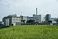
The Hochdorf Nutritec AG in Hochdorf
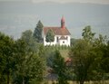
Chapel in Urswil

Parish church
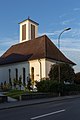
reformed Church

town hall
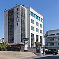
Braui

Peter Halter School House
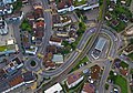
Town center from the air


Personalities
- Jost Bernhard Häfliger (1759–1837), pastor, promoter of rural education and pioneer of dialect literature
- August Frey (1912–1998), painter and graphic artist
- Jakob Frey (1681–1752), engraver and publisher of graphic works
- Theo Frey (908–1997), photographer
- Leodegar Ineichen († 1876), last abbot (1859–1862) of the Rheinau monastery
- Erich Mächler (* 1960), racing cyclist
- Joseph Widmer (1779–1844), professor at the Lucerne Lyceum and provost in Beromünster
literature
- Othmar Wey, Waltraud Hörsch: Hochdorf (community). In: Historical Lexicon of Switzerland . December 18, 2007 .
- Waltraud Hörsch: Baldegg (settlement). In: Historical Lexicon of Switzerland . January 11, 2002 .
Web links
- Official website of the municipality of Hochdorf
- Community profile of the cantonal statistical office for 2018 (PDF)
Individual evidence
- ↑ Permanent and non-permanent resident population by year, canton, district, municipality, population type and gender (permanent resident population). In: bfs. admin.ch . Federal Statistical Office (FSO), August 31, 2019, accessed on December 22, 2019 .
- ↑ Permanent resident population according to nationality category, gender and municipality ( memento of the original from January 1, 2015 in the Internet Archive ) Info: The archive link was inserted automatically and has not yet been checked. Please check the original and archive link according to the instructions and then remove this notice. (Permanent resident population)
- ↑ ortsnames.ch , accessed on January 3, 2020.
- ↑ Balance of the permanent resident population according to demographic components, institutional structure, nationality and gender (Federal Statistical Office, STAT-TAB)
- ↑ LUSTAT: Community profile Hochdorf ( Memento of the original from May 8, 2016 in the Internet Archive ) Info: The archive link was inserted automatically and has not yet been checked. Please check the original and archive link according to the instructions and then remove this notice.
- ↑ Lexicon of Swiss municipality names . Edited by the Center de Dialectologie at the University of Neuchâtel under the direction of Andres Kristol. Frauenfeld / Lausanne 2005, p. 447.
- ↑ LUSTAT Statistics Lucerne. Retrieved August 1, 2020 .
- ^ Federal Statistical Office : NR - Results parties (municipalities) (INT1). In: Federal Elections 2019 | opendata.swiss. August 8, 2019, accessed August 1, 2020 .
- ↑ Seetal-Bözberg route on schweizmobil.ch. Retrieved February 5, 2020.
Aesch | Altwis | Ballwil | Emmen | Ermensee | Eschenbach | Hitzkirch | Hochdorf | Hohenrain | Inwil | Rain | Römerswil | Rothenburg | Schongau
Former communities: Gelfingen | Hemicon | Herlisberg | Lieli | Mosen | Müswangen | Retschwil | Richensee | Sulz
Canton of Lucerne | Constituencies of the Canton of Lucerne | Municipalities of the Canton of Lucerne