
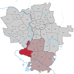
Böllberg / Wörmlitz
|
district of Halle (Saale) |
|
|---|---|
 _Stadtteil_4_60.svg) |
|
| Coordinates | 51 ° 26 '39 " N , 11 ° 56' 39" E |
| Residents | 2566 (Dec. 31, 2013) |
| prefix | 0345 |
| Saxony-Anhalt | |
| Transport links | |
| tram | 1 |
Böllberg / Wörmlitz is a district of the city of Halle (Saale) in Saxony-Anhalt , Germany .
location
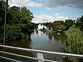
The two former fishing villages of Böllberg and Wörmlitz an der Saale are located south of the former city of Glaucha . The small village of Böllberg, located directly in front of the Hamstertor, was significantly more strongly embossed and is now dominated by the extensive complex of the Böllberger Mühle, whereas the southern Wörmlitz retained its village character. The two villages are connected with each other and with the old town by the Böllberger Weg and its northern continuation Glauchaer Straße. Böllberg is located between the Böllberger Weg and the Saale, while Wörmlitz is located in the gusset between the Saale and the Südstadtring. Furthermore, a more recent new housing estate on both sides of Kaiserslauterner Strasse south of Wörmlitz belongs to the district. The Rabeninsel is enclosed by two arms of the Saale west of Böllberg , which until the 1990s could only be reached by ferry from Böllberg / Wörmlitz, but is now connected by a fixed bridge. To the east of the district, the extensive Südstadt was built in the second half of the 20th century , extending to the streets mentioned above. In the southeast, the district borders on the large housing estate Silberhöhe , built in the 1980s .
history
Despite the proximity to the old town of Halle, the villages are only mentioned in the High Middle Ages. Böllberg is called Belberge around 1272 . The documentary mention of a Boliboris ascribed to Böllberg in 1012 cannot be this village, as it neither belonged to the diocese of Merseburg like this Boliboris, nor was any of the numerous other places mentioned in the document nearby.
Wörmlitz was first tangible as a worm lice around 1121 . Here, too, place name research has so far not produced a convincing result, constructing an extensive deformation of the place name. A second village of Wörmlitz is documented for the first time in 1184, so a distinction is made between minor and major Wermelitz . This Klein-Wörmlitz (documented parvo Wrmeliz ) seems to have had a difficult time, is indicated several times as a desert, so that Erich Neuss assumes that it fell in ruins before 1371, but it seems to have continued to exist because it should was not finally destroyed until 1636, so it was not rebuilt. It was located in the area of today's Angerstrasse. The white Wörmlitzer sandstone, from which public and private buildings were built in Halle in the Middle Ages, and which became a household name as Wormenitzer , was important.
Böllberg and Wörmlitz belonged to the Giebichenstein office in the hall circle of the ore monastery of Magdeburg . In 1680 both places with the Saalkreis came to the Duchy of Magdeburg under Brandenburg-Prussian rule. With the Peace of Tilsit in 1807, Böllberg and Wörmlitz were incorporated into the Kingdom of Westphalia and assigned to the Halle district in the Saale department. The places came to the canton of Glaucha . After Napoleon's defeat and the end of the Kingdom of Westphalia, Napoleon's allied opponents liberated the Saalkreis in early October 1813. During the political reorganization after the Congress of Vienna in 1815, Böllberg and Wörmlitz were attached to the Merseburg administrative district of the Prussian province of Saxony in 1816 and assigned to the Saalkreis.
Around 1920 Böllberg and Wörmlitz were merged to form the municipality of Wörmlitz-Böllberg, which was incorporated into Halle (Saale) on July 1, 1950.
Attractions
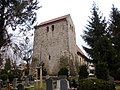
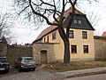
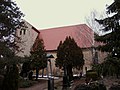
Although the most striking building in the district is the water tower of the Böllberger Mühle, which towers like a donjon and is visible from a great distance, the Böllberg Church of St. Nikolaus is the most culturally and historically important building and has been included in the Romanesque Route as it represents an example of one of the few remaining towerless and small Romanesque churches. It is dated to the late twelfth century. The actual core of the village of Böllberg is located south of the Böllberger Mühle or the Böllberger Church. where there is an 18th century inn on the village square. To the south of the retirement home are three stones, which are popularly known as Müllerstones and are mistaken for cross stones.
Wörmlitz largely retained its village appearance with farmsteads along the streets, but the multi-arched railway bridge on the Halle-Kassel line over the Saale with the embankment was built in the 19th century in the Saale meadow. The massive west tower of the Church of St. Petrus also dates from the twelfth century.
gallery

St. Nikolaus Böllberg Church
Saaleblick Böllberg

St. Nikolaus Böllberg Church
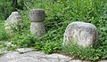
Müllersteine Böllberg
Church of St. Petrus Wörmlitz

Heinrich-Heine-Strasse Wörmlitz
Richard-Schatz-Strasse Wörmlitz

Wörmlitz manor
Church of St. Petrus Wörmlitz

Richard-Schatz-Strasse Wörmlitz

Saaleufer Rabeninsel

Saaleufer Rabeninsel


literature
- Brülls, Holger / Honekamp, Dorothee, City of Halle (= Monument Register Saxony-Anhalt; 4), Halle (Saale) 1996.
- Findeisen, Peter / Höhne, Dirk, The village churches in Halle, Halle (Saale) 2006.
- Erich Neuss : Desert Studies of the Saalkreis and the City of Halle , Weimar 1969.
- Richter, Albert, The place names of the Saalkreis (= German-Slavic research on naming and settlement history; 15), Berlin 1962.
- Hall, Walter , stone crosses and cross stones in the Halle district, Merseburg 1989.
Web links
Individual evidence
- ^ Richter, p. 16.
- ↑ Neuss, pp. 339-340.
- ↑ Mention of the places in the book "Geography for all Stands", pp. 124 and 126
- ^ Description of the Saale Department
- ^ The hall circle in the municipality register 1900
- ↑ Halle (Saale) and its districts on gov.genealogy.net
- ↑ For example from Walter Saal.
.svg)
Old town | Ammendorf / Beesen | At the water tower / Thaerviertel | Böllberg / Wörmlitz | Büschdorf | Damaschkestrasse | Dautzsch | Diemitz | Diesel road | Dölau | Dölauer Heide | Freiimfelde / Kanenaer Weg | Happy future | Territory of the DR | Gesundbrunnen | Neustadt industrial park | Giebichenstein | Gottfried-Keller-Siedlung | Heide-Nord / Blumenau | Heide-Süd | North industrial area | Kanena / Bruckdorf | Kröllwitz | Landrain | Lettin | Lutherplatz / Thuringian Railway Station | Possible | Rivet life | Northern city center | Northern New Town | Paulusviertel | Planena | Radewell / Osendorf | Reideburg | Saale floodplain | Seeben | Silver height | South downtown | Southern New Town | Südstadt | Tornau | Trotha | Western New Town