
Wullersdorf
|
market community Wullersdorf
|
||
|---|---|---|
| coat of arms | Austria map | |
 |
|
|
| Basic data | ||
| Country: | Austria | |
| State : | Lower Austria | |
| Political District : | Hollabrunn | |
| License plate : | HL | |
| Surface: | 63.89 km² | |
| Coordinates : | 48 ° 38 ' N , 16 ° 6' E | |
| Height : | 248 m above sea level A. | |
| Residents : | 2,352 (Jan 1, 2020) | |
| Postal code : | 2041 | |
| Area code : | 02951 | |
| Community code : | 3 10 51 | |
| NUTS region | AT125 | |
| Address of the municipal administration: |
Bahnstrasse 255 2041 Wullersdorf |
|
| Website: | ||
| politics | ||
| Mayor : | Richard Hogl ( ÖVP ) | |
|
Municipal Council : ( 2020 ) (21 members) |
||
| Location of Wullersdorf in the Hollabrunn district | ||
  |
||
.JPG) Parish church Wullersdorf hl. George |
||
| Source: Municipal data from Statistics Austria | ||

Wullersdorf is a market town with 2352 inhabitants (as of January 1, 2020) in the Hollabrunn district in Lower Austria .
geography
Wullersdorf is located in the northern Weinviertel in Lower Austria. The area of the market town covers 63.89 square kilometers. About four percent of the area is forested.
Community structure
The municipality includes the following ten localities (population in brackets as of January 1, 2020):
- Aschendorf (55)
- Grund (232) including the Grund-Bahnhofsiedlung and Hetzmannsdorf-Wullersdorf train station
- Hard (77)
- Hetzmannsdorf (139)
- Immendorf (394)
- Kalladorf (244)
- Maria Roggendorf (128)
- Oberstinkenbrunn (217)
- Schalladorf (133)
- Wullersdorf (733)
The community area is divided into eleven cadastral communities (area 2016):
- Aschendorf (142.06 ha)
- Land (1,245.93 ha)
- Hard (316.48 ha)
- Hetzmannsdorf (229.93 ha)
- Immendorf (1,234.79 ha)
- Kalladorf (669.77 ha)
- Oberstinkenbrunn (670.45 ha)
- Raffelhof (221.51 ha)
- Roggendorf (289.71 ha)
- Schalladorf (491.76 ha)
- Wullersdorf (879.76 ha)
Neighboring communities
| Guntersdorf | Haugsdorf , Alberndorf (Raabs an der Thaya municipality) , Hadres , Retz | Mailberg |
.svg)
|
Nappersdorf-Kammersdorf | |
| Digging | Hollabrunn |
history
The area around Wullersdorf was settled around the year 1000 AD. In 1108 a church was consecrated, Wullersdorf was raised to a parish and the Babenbergs donated the parish to Melk Abbey. By the end of the 15th century, two manors had been formed, the larger belonging to the Counts of Hardegg, the smaller to Melk Abbey. In 1651 the Melk Monastery bought the Hardegger's property and became sole owner until 1848. From 1848 the former subjects could acquire land as property.
coat of arms
In the golden shield is a black eagle with a breast shield divided into blue and gold.
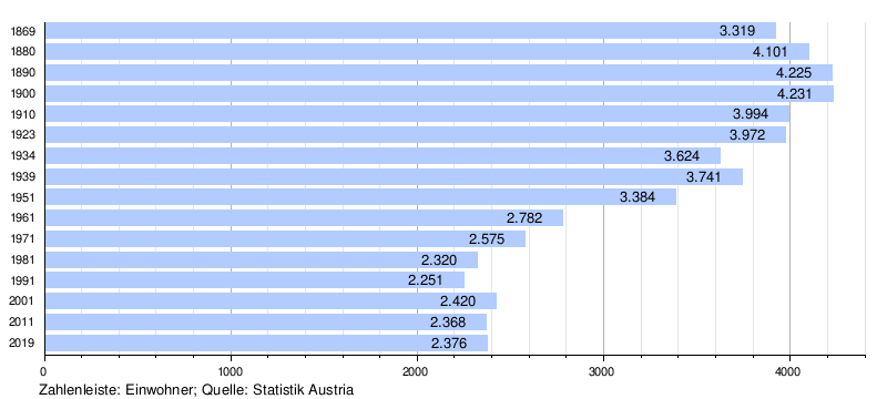
Population development
The population has remained constant since 1981, as the positive balance of migration cancels out the negative balance of births .
politics
The municipal council has 21 members.
- With the municipal council elections in Lower Austria in 1990, the municipal council had the following distribution: 12 ÖVP, 5 FPÖ, 3 SPÖ and 1 citizen list Tradinki (ÖVP).
- With the municipal council elections in Lower Austria in 1995, the municipal council had the following distribution: 13 ÖVP, 5 SPÖ and 3 FPÖ.
- With the municipal council elections in Lower Austria in 2000, the municipal council had the following distribution: 13 ÖVP, 6 SPÖ and 2 FPÖ.
- With the municipal council elections in Lower Austria in 2005 , the municipal council had the following distribution: 12 ÖVP, 7 SPÖ, 1 FPÖ and 1 Greens.
- With the municipal elections in Lower Austria in 2010 , the municipal council had the following distribution: 13 ÖVP, 6 SPÖ, 1 FLR - for our living space and 1 FPÖ.
- With the municipal council elections in Lower Austria 2015 , the municipal council had the following distribution: 14 ÖVP, 5 SPÖ and 2 FPÖ.
- With the municipal council elections in Lower Austria 2020 , the municipal council has the following distribution: 14 ÖVP, 5 SPÖ and 2 FPÖ.
- mayor
- until 2010 Ignaz Pimberger (ÖVP)
- since 2010 Richard Hogl (ÖVP)
Culture and sights


- Catholic Basilica Roggendorf Nativity
- Catholic parish church Immendorf hl. Catherine
- Catholic parish church Oberstinkenbrunn hl. Leonhard
- Catholic parish church Wullersdorf hl. George
- Cistercian Abbey Marienfeld in Maria Roggendorf
- Kalladorf Farm Museum
economy
In 2010 there were 122 agricultural and forestry holdings, compared with 163 in the 1999 survey. Around two thirds are full-time farms that farm almost three quarters of the area. In the manufacturing sector there are 25 companies employing 154 people, more than three quarters in construction. The service sector employs 257 people in 113 companies, around 100 in social and public services and 80 in trade (as of 2010).
traffic
- Train: Wullersdorf is on the Nordwestbahn with the Hetzmannsdorf-Wullersdorf train station and direct connections to Vienna, Retz and Znojmo .
- Road: The Weinviertler Straße B303 leads from Hollabrunn to Znojmo through the western municipal area . The extension of the S3 Weinviertel expressway has been under construction since 2017 . It will have its own Wullersdorf exit and is expected to be completed in 2020.
education
There are two kindergartens, an elementary school and a middle school in the community.
health
A general practitioner ordained in Wullersdorf.
Personalities
- Sons and daughters of the church
- Karl Frieberth (1736–1816), composer, singer and librettist, conductor at the University of Vienna
- Alexander Karl (1824–1909), abbot of Melk Abbey , politician
- Johann Eichinger (1886–1967), farmer and politician
- Hans Naderer (1891–1971), writer
- Robert Löffler (1930–1989), politician (ÖVP)
- Georg Wilfinger (* 1949), abbot of Melk Abbey
- Markus Suttner (* 1987), professional soccer player
Web links
- 31051 - Wullersdorf. Community data, Statistics Austria .
Individual evidence
- ↑ Statistics Austria: Population on January 1st, 2020 by locality (area status on January 1st, 2020) , ( CSV )
- ↑ Federal Office for Metrology and Surveying, Regional Information, reference date December 31, 2016, accessed February 19, 2017
- ↑ Wullersdorf community, history. Retrieved October 13, 2019 .
- ^ Statistics Austria, A look at the community of Wullersdorf, population development. Retrieved October 13, 2019 .
- ^ Result of the municipal council elections 1995 in Wullersdorf. Office of the Lower Austrian State Government, March 30, 2000, accessed on March 27, 2020 .
- ^ Election result of the municipal council election 2000 in Wullersdorf. Office of the Lower Austrian State Government, February 4, 2005, accessed on March 27, 2020 .
- ^ Election result of the municipal council election 2005 in Wullersdorf. Office of the Lower Austrian State Government, March 4, 2005, accessed on March 27, 2020 .
- ^ Election result of the municipal council election 2010 in Wullersdorf. Office of the Lower Austrian State Government, October 8, 2010, accessed on March 27, 2020 .
- ^ Election results for the 2015 municipal council election in Wullersdorf. Office of the Lower Austrian State Government, December 1, 2015, accessed on March 27, 2020 .
- ↑ Results of the municipal council election 2020 in Wullersdorf. Office of the Lower Austrian State Government, January 26, 2020, accessed on March 27, 2020 .
- ↑ Statistics Austria, A look at the community of Wullersdorf, agricultural and forestry operations. Retrieved October 13, 2019 .
- ^ Statistics Austria, A look at the community of Wullersdorf, workplaces. Retrieved October 13, 2019 .
- ^ Statistics Austria, A look at the community of Wullersdorf, employees. Retrieved October 13, 2019 .
- ↑ OEBB, departure board at Hetzmannsdorf-Wullersdorf station. Retrieved October 13, 2019 .
- ↑ OpenStreetMap, Wullersdorf. Retrieved October 13, 2019 .
- ^ Asfinag, S 3 Weinviertler Schnellstraße Hollabrunn to Guntersdorf. Retrieved October 13, 2019 .
- ^ Community Wullersdorf, kindergartens / schools. Retrieved October 13, 2019 .
- ^ Community Wullersdorf, Doctors & Pharmacies. Retrieved October 13, 2019 .

Alberndorf im Pulkautal | Göllersdorf | Digging | Guntersdorf | Hadres | Hardegg | Haugsdorf | Heldenberg | Hohenwarth-Mühlbach am Manhartsberg | Hollabrunn | Mailberg | Maissau | Nappersdorf-Kammersdorf | Pernersdorf | Pulkau | Ravelsbach | Retz | Retzbach | Schrattenthal | Seefeld-Kadolz | Sitzendorf an der Schmida | Wullersdorf | Zellerndorf | Ziersdorf
Cadastral communities: Aschendorf | Reason | Hard | Hetzmannsdorf | Immendorf | Kalladorf | Oberstinkenbrunn | Raffelhof | Roggendorf | Schalladorf | Wullersdorf
Locations: Aschendorf | Reason | Hard | Hetzmannsdorf | Immendorf | Kalladorf | Maria Roggendorf | Oberstinkenbrunn | Schalladorf | Wullersdorf
Market place: Wullersdorf Villages: Aschendorf | Reason | Hard | Hetzmannsdorf | Immendorf | Kalladorf | Maria Roggendorf | Oberstinkenbrunn | Schalladorf settlement: Grund-Bahnhofsiedlung | Group of houses: Hetzmannsdorf-Wullersdorf-Bahnstation | Other locations: Gottelhof | Marienfeld Monastery | Nexenhof | Raffelhof
Counting district: Wullersdorf | Kalladorf | Maria Roggendorf | Schalladorf | Oberstinkenbrunn | Hetzmannsdorf | Reason | Immendorf | Hard | Aschendorf