
Waltershofen (Freiburg im Breisgau)
|
Freiburg im Breisgau |
|
|---|---|
| City district Freiburg (FR) Baden-Wuerttemberg , Germany |
|

|
|
| Basic data | |
| District with local administration of Freiburg | |
| District number: | 56 |
| Structure: | 1 district (560) |
| incorporated on: | July 1, 1972 |
| Geographic location : | 48 ° 1 '26 " N , 7 ° 43' 17" E |
| Height : | 200 m above sea level NN |
| Area : | 6.29 km² |
| Residents : | 2,169 (January 1, 2018) |
| Population density : | 345 inhabitants per km² |
| Proportion of foreigners : | 6% |
| Postal code : | 79112 |
| Area code : | 07665 |
Administration address : |
Local administration Waltershofen Schulhalde 12 79112 Freiburg |
| Internet presence: | Freiburg-Waltershofen |
| politics | |
| Mayor : | Petra Zimmermann |
| Dialect: Alemannic | |
| Main variant: | Lower Alemannic |
| Regional variant: | Upper Rhine Manish |
| Local variant: | Breisgau |
Waltershofen is a district with its own local administration of the city of Freiburg im Breisgau . It is located approx. 15 km west of the city on the Tuniberg in the vicinity of the independent communities of Gottenheim , Merdingen and Umkirch in the Breisgau-Hochschwarzwald district and the village of Opfingen to the south , also a district of Freiburg.
2169 people live in Waltershofen (Jan. 2018). The area of the district is 629.10 ha (as of December 31, 2010).
The partner town is Waltershofen in the Allgäu .
history
Waltershofen was first mentioned in a document in 1139. During the Middle Ages, the village belonged to the St. Märgen monastery . Various noble families from Breisgau, such as the Schnewlin and the Dachswangen, were the local lords. Due to impoverishment, the St. Märgen Monastery had to sell this property at the end of the 15th century. Alternating aristocratic families continued to rule over the place, which fell to the state of Baden in 1806 and with this became part of the state of Baden-Württemberg in 1952. On July 1, 1972, the village was incorporated into Freiburg. Petra Zimmermann has been the mayor since 2015.
landscape
In the southeast of the Waltershofen district, bordering the Rieselfeld nature reserve and the Mundenhof , lies the Mooswald nature reserve . It is cut in north-south direction by the federal highway 5 . To the west of it lies the Waltershofener See. It was created from 1967 to 1969 through gravel mining for the Freiburg-Mitte motorway access road and is the most nutrient-polluted lake in Baden-Württemberg. These were entered through the groundwater from the Freiburg Rieselfeld until the early 1980s. The result was algae blooms and fish deaths, as oxygen was no longer available from a water depth of two meters. Since 2010, the water has been circulated using solar power, so oxygen also reaches deeper layers.
Buildings
The center of the village is the Catholic parish church of St. Peter and Paul , which was built by Christoph Arnold in the Weinbrenner style between 1816 and 1819 , after the parish of Wippertskirch, which was also the church of the Schuttern monastery since 1136, moved to Waltershofen in 1815 was relocated. The church was built in Waltershofen on the site of a St. Margareten chapel, which had stood there since around 1270.
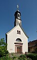
St. Peter and Paul main entrance
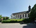
Catholic Church of
St. Peter and Paul
Grave tablets on
St. Peter and Paul
_1.jpg)
_2.jpg)
.jpg)
Web links
- Local administration Waltershofen on the side of the city of Freiburg
- Small town secret tips Waltershofen
- Local history
Individual evidence
- ^ Federal Statistical Office (ed.): Historical municipality directory for the Federal Republic of Germany. Name, border and key number changes in municipalities, counties and administrative districts from May 27, 1970 to December 31, 1982 . W. Kohlhammer, Stuttgart / Mainz 1983, ISBN 3-17-003263-1 , p. 493 .
- ^ Hermann Brommer : Catholic parish church of St. Peter and Paul Freiburg-Waltershofen . Schnell and Steiner, Munich 1987.
.jpg)
Old town | Betzenhausen | Brühl | Dietenbach | Levels | Günterstal | Haslach | Herdern | Hochdorf | Kappel | Land water | Fiefdom | Littenweiler | Moss forest | Mundenhof | Munzingen | Neuburg | Oberau | Opfingen | Rieselfeld | St. Georgen | Stühlinger | Tiengen | Vauban | Forest lake | Waltershofen | Vineyard | Wiehre | Zähringen