Werderland (nature reserve)
|
Werderland
|
||
|
"Werderland" nature reserve |
||
| location | Bremen , Free Hanseatic City of Bremen | |
| Area / extent | 330.7 ha / 8 km | |
| Identifier | 14th | |
| WDPA ID | 166248 | |
| Geographical location | 53 ° 9 ' N , 8 ° 39' E | |
|
|
||
| Sea level | from 1 m to 6.5 | |
| Setup date | October 18, 1996 | |
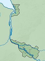
The Werder land is a nature reserve in the same river lowland landscape in the district Werderland the district Burglesum the municipality of Bremen .
General
The now 330.7 hectare nature reserve is entered in the nature reserve book of the city of Bremen under number 14. Part of the area has been part of the 392.5 hectare FFH area of the same name since the end of 2010 . Furthermore, the nature reserve is completely part of the 847.7 hectare EU bird reserve of the same name . In the northeast it borders directly on the nature reserve " Dunger See ". Most of the adjoining nature reserve areas is the 471.2-hectare conservation area "Werder country and Lesum reeds". An area of 241 hectares in the eastern part of Werderland was placed under nature protection on October 18, 1996 as "Werderland (Part 1)". In December 2010, the nature reserve was the inclusion of other grassland areas in the north and west of the nature reserve and the largest part of the Spülfeldes Niederbüren that connects directly to the existing nature reserve in the south, and the Schönebecker sand in the northwest of the Weser country on an area of 330, 7 hectares expanded. The responsible nature conservation authority is the Senator for Environment, Building and Transport.
description
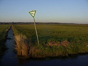
The protected area is an extensive grassland complex that is criss-crossed by numerous ditches . It is characterized by wet meadows and wet waste land with marsh zones and reed beds and Hochstaudenfluren coined. In the nature reserve there are several small still waters , some of which have been created. In the south, on the edge of the Niederbüren flushing field, there is a rest of alluvial forest . Most of the grassland areas are used extensively or lie fallow.
The nature reserve, which has been cared for by the Bremen Regional Association of the BUND since 1998 , is an important habitat for numerous animals and plants adapted to damp locations. So live here u. a. Pipe and Harrier , Reed Bunting , Whinchat , Bluethroat , various warblers such. B. Reed warbler and reed warbler and swirls such. As the grasshopper warbler , skylark , yellow wagtail , Meadow Pipit , Spotted Crake , corncrake , short-eared owl , kingfisher and red-backed shrike . The wet meadows are also an important habitat for various wading birds , including lapwing , redshank , snipe and wood sandpiper . The area is also an important habitat for various ducks . White stork and great egret use the area as a feeding habitat. In the grassland areas settle u. a. Meadowfoam , ragged robin , Lysimachia Thyrsiflora , Bogbean , Yellow meadow rue , Marsh Cinquefoil , water ragwort , marsh pea , buttercups and sorrel .
The trenches in the nature reserve are the habitat of the wolffish . Furthermore settle here u. a. Crab claws , water crowfoot and water feathers as well as marsh marigold and swan flower on the banks. The trenches and ponds in the nature reserve are also habitat for various dragonflies and amphibians .
35 species of butterflies have been identified in the nature reserve , including mirror-spotted thick-headed butterflies , green rams and small fire butterflies . This makes the area the most species-rich area for butterflies in all of Bremen. The sand flushing field Niederbüren as a dry habitat offers z. B. various ground beetles , wild bees and the blue-winged wasteland insect a habitat. Silver grass and mountain sand bells also settle here. The area with the small bodies of water on the edge are the habitat of natterjack toads and garlic toads. The Stülfeld is grazed for maintenance in order to counteract bush encroachment.
The BUND has created an eco-path through the nature reserve that can be accessed all year round. Another hiking trail is to the east on the edge of the ArcelorMittal factory premises . At this there is a viewing pavilion, the "Ilsenburger Hut".
See also
Web links
- Overview of nature reserves, No. 14 , Bremen Environmental Information System, Senator for the Environment, Building and Transport
- Werderland and Dunger See , Protected Areas in the State of Bremen, Brochure of the Free Hanseatic City of Bremen (PDF file, 3.1 MB)
- Leaflet "Werderland Nature Reserve (Part 1)" , Nature Reserves in the State of Bremen - No. 5, BUND, Landesverband Bremen e. V. and Senator for Building and Environment, Bremen 1999 (PDF; 268 kB)
- Werderland: Biotope on two rivers , NDR, 23 May 2017
Individual evidence
- ↑ 2817-301 Werderland. (FFH area) Profiles of the Natura 2000 areas. Published by the Federal Agency for Nature Conservation . Retrieved March 21, 2018.
- ↑ 2817-401 Werderland. (EU bird sanctuary) Profiles of the Natura 2000 areas. Published by the Federal Agency for Nature Conservation . Retrieved March 21, 2018.
- ^ Werderland , BUND, State Association Bremen. Retrieved March 22, 2018.
- ↑ By bike through the Bremer Feuchtwiesenring, part of North West (Werderland) , nature experience, Free Hanseatic City of Bremen. Retrieved March 20, 2015.
- ↑ Julia Ladebeck: Nature conservationists want to use herds to maintain the landscape , Weser-Kurier, June 1, 2017. Accessed March 22, 2018.
- ^ Werderland , Adventure Space Nature, Free Hanseatic City of Bremen. Retrieved March 22, 2018.


