Wertheim (Wertheim)
|
Wertheim
City of Wertheim
Coordinates: 49 ° 45 ′ 28 ″ N , 9 ° 31 ′ 3 ″ E
|
||
|---|---|---|
| Height : | 139 m above sea level NHN | |
| Residents : | 3118 (December 31, 2017) | |
| Postal code : | 97877 | |
| Area code : | 09342 | |
|
Location of Wertheim in Baden-Württemberg |
||
|
Wertheim am Main, cityscape as seen from the Main
|
||
Wertheim is the core town , suburb and administrative seat of the town of the same name in Wertheim in the Main-Tauber district of Baden-Württemberg in the administrative district of Stuttgart .
geography
Geographical location
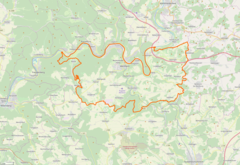
![]() Map with all coordinates of the places of the core city Wertheim: OSM
Map with all coordinates of the places of the core city Wertheim: OSM
Wertheim is 139 m above sea level. NHN on the left bank of the Main on the south-eastern edge of the Spessart . For the district area of the core town of Wertheim with 1920 hectares include the Old Town Wertheim ( ⊙ ) that risen in the core city neighborhoods bridge area ( ⊙ ) Mühlenviertel ( ⊙ ) and Tauber district ( ⊙ ) and the districts Bestenheid ( ⊙ ), Eichel / Hofgarten ( ⊙ ) with Eichel ( ⊙ ) and Hofgarten ( ⊙ ), Reinhardshof ( ⊙ ) with the housing area Besteheider Höhe ( ⊙ ), Vockenrot ( ⊙ ) and Wartberg ( ⊙ ) and the housing area Haidhof ( ⊙ ) and Neuhof ( ⊙ ).
The state roads 506 , 508 and 2310 lead through the core town of Wertheim .
Neighboring marks
Neighboring markings starting clockwise in the north are Kreuzwertheim , Urphar , Reicholzheim , Waldenhausen , Sachsenhausen , Nassig , Grünenwört and Hasloch .
Waters
From the left, the Dellengraben in the south of the district and the Staffelwehrklinge in the south of the town flow into the Tauber , which flows into the Main in the north of the town .
history

|

|
|
|
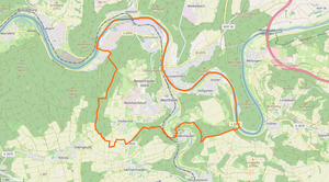
Location and demarcation of the community of Wertheim as well as the district boundary of the core city of Wertheim.
|
||
In 1806 Wertheim came under Baden sovereignty, at that time the right Main part of the district was separated. The core town of Wertheim remained the seat of the lower administrative authority until 1938 and was then assigned to the district office and later district of Tauberbischofsheim . In 1913 Besteheid, 1935 Eichel and 1939 Vockenrot were combined with the district.
Wertheim belonged to the Tauberbischofsheim district until it was dissolved. Wertheim has been part of the Main-Tauber district since January 1, 1973 . On December 31, 2017, Wertheim had 3118 inhabitants, of which 1123 lived on the right of the Tauber and 1995 on the left of the Tauber.
religion
Wertheim is influenced by Protestants. The monastery parish belongs to the Evangelical Church District Wertheim . The Catholic parish of St. Venantius belongs to the deanery Tauberbischofsheim in the Archdiocese of Freiburg . There are also associations of Jehovah's Witnesses and Muslims .
politics
The old town council consists of seven residents.
Culture and sights
traffic
Personalities
Web links
Individual evidence
- ↑ a b Breakdown of the population of the city of Wertheim including sub-locations. (PDF) City of Wertheim, accessed on September 4, 2018 (via: Numbers, data, facts / calculation: right the Tauber, left the Tauber).
- ↑ a b c d e f LEO-BW.de: Wertheim - Altgemeinde ~ Teilort . Online at www.leo-bw.de. Retrieved March 10, 2018.
- ↑ Right click on the BayernAtlas of the Bavarian State Government ( information ).
- ↑ Wertheim.de - Numbers, data, facts. Wertheim city administration, accessed on August 12, 2017.
- Jump up ↑ Brückenviertel - Rise - Detail page - LEO-BW. In: leo-bw.de. Retrieved May 12, 2020 .
- ↑ Mühlenviertel - Risen - detail page - LEO-BW. In: leo-bw.de. Retrieved May 12, 2020 .
- ↑ Tauberviertel - up - detail page - LEO-BW. In: leo-bw.de. Retrieved May 12, 2020 .
- ↑ Besteheid - living space - detail page - LEO-BW. In: leo-bw.de. Retrieved May 12, 2020 .
- ↑ Eichel - living space - detail page - LEO-BW. In: leo-bw.de. Retrieved May 12, 2020 .
- ↑ Hofgarten - living space - detail page - LEO-BW. In: leo-bw.de. Retrieved May 12, 2020 .
- ↑ Reinhardshof - living space - detail page - LEO-BW. In: leo-bw.de. Retrieved May 12, 2020 .
- ↑ Besteheider Höhe - living space - detail page - LEO-BW. In: leo-bw.de. Retrieved May 12, 2020 .
- ↑ Vockenrot - living space - detail page - LEO-BW. In: leo-bw.de. Retrieved May 12, 2020 .
- ↑ Wartberg - living space - detail page - LEO-BW. In: leo-bw.de. Retrieved May 12, 2020 .
- ↑ Haidhof - living space - detail page - LEO-BW. In: leo-bw.de. Retrieved May 12, 2020 .
- ↑ Neuhof - living space - detail page - LEO-BW. In: leo-bw.de. Retrieved May 12, 2020 .
- ↑ Evangelical parish Wertheim. Evangelical Dean's Office Wertheim, accessed on August 12, 2017 .
- ↑ Parish Wertheim. Deanery Tauberbischofsheim, accessed on August 12, 2017 .
- ↑ Associations. Marktplatz-Deutschland.de GmbH, accessed on August 12, 2017 .
- ↑ Old Town Advisory Board


