
Mount Maxwell Provincial Park: Difference between revisions
add ref section |
Reverted 1 edit by 24.68.45.206 (talk): And that's a file name. |
||
| (18 intermediate revisions by 9 users not shown) | |||
| Line 1: | Line 1: | ||
{{Short description|Provincial park in British Columbia, Canada}} |
|||
| ⚫ | |||
{{Infobox protected area |
|||
| name = Mount Maxwell Provincial Park |
|||
| alt_name = |
|||
| iucn_category = II |
|||
| iucn_ref = <ref>{{Cite web|title=Mount Maxwell Park|url=https://www.protectedplanet.net/10450|access-date=2020-09-25|website=Protected Planet}}</ref> |
|||
| photo = View from Baynes Peak, Saltspring Island, British Columbia, Canada 04.jpg |
|||
| photo_width = 260px |
|||
| photo_alt = |
|||
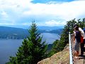
| photo_caption = View from Baynes Peak |
|||
| map = British Columbia##CAN BC Capital |
|||
| map_width = 260px |
|||
| map_alt = |
|||
| map_caption = Location in British Columbia##Location in [[Capital Regional District]] |
|||
| relief = |
|||
| label = |
|||
| label_position = |
|||
| mark = |
|||
| marker_size = |
|||
| location = [[Salt Spring Island]], [[British Columbia]] |
|||
| nearest_city = [[Duncan, British Columbia|Duncan]] |
|||
| ⚫ | |||
| coords_ref = |
|||
| area_ha = 231 |
|||
| designation = [[BC Parks#Designations|Provincial Park]] |
|||
| authorized = |
|||
| created = 1938 |
|||
| designated = |
|||
| established = |
|||
| visitation_num = |
|||
| visitation_year = |
|||
| visitation_ref = |
|||
| governing_body = [[BC Parks]] |
|||
| administrator = |
|||
| operator = |
|||
| owner = |
|||
| world_heritage_site = |
|||
| website = {{url|http://bcparks.ca/explore/parkpgs/mt_maxwell/|BC Parks Mt Maxwell}} |
|||
| url = |
|||
| child = |
|||
| embedded = |
|||
}} |
|||
| ⚫ | |||
It was established in 1938 for the views afforded from Baynes Peak |
It was established in 1938 for the views afforded from '''Baynes Peak''', the highest point on the mountain,<ref name="bcgeobaynes">{{cite web|title=Baynes Peak|url=http://apps.gov.bc.ca/pub/bcgnws/names/12512.html|website=BC Geographical Names|publisher=BC Government|access-date=3 September 2016}}</ref> which encompass [[Vancouver Island]], the [[Gulf Islands]] and mainland British Columbia. It has an area of 231 hectares, but is adjoined by the [[Mount Maxwell Ecological Reserve]] to the west, and [[Burgoyne Bay Provincial Park]] to the south, creating a contiguous area of over 1100 ha of protected land.<ref name="mmpp">{{cite web|title=Mount Maxwell Provincial Park|url=http://www.env.gov.bc.ca/bcparks/explore/parkpgs/mt_maxwell/|publisher=Province of British Columbia|access-date=29 August 2016}}</ref> |
||
The mountain top can be accessed by gravel road, or by hiking trails from the north-east or Burgoyne Bay Provincial Park to the south.<ref name="map">{{cite web|title=Mount Maxwell Provincial Park (Map)|url=http://www.env.gov.bc.ca/bcparks/explore/parkpgs/mt_maxwell/mt-maxwell-map.pdf?v=1472474617153|publisher=Province of British Columbia| |
The mountain top can be accessed by gravel road, or by hiking trails from the north-east or Burgoyne Bay Provincial Park to the south.<ref name="map">{{cite web|title=Mount Maxwell Provincial Park (Map)|url=http://www.env.gov.bc.ca/bcparks/explore/parkpgs/mt_maxwell/mt-maxwell-map.pdf?v=1472474617153|publisher=Province of British Columbia|access-date=29 August 2016}}</ref> It has an elevation of 580m above sea level.<ref name="topo">{{cite web|title=The Atlas of Canada - Toporama|url=http://atlas.nrcan.gc.ca/toporama/en/index.html#?id=map1&extent=-2027977.5594076072,439514.8383024995,-2026072.5555975996,440467.3402075033&legend=762eb7ed-0001-242f-6fcf-af08f5605eb1,0,0,1;e5511402-0002-5cbe-0d3c-f537c612b7df,0,0,0.7;cc7fde4c-0003-1cf2-8358-7ca86eefb13c,0,0,1;762eb7ed-cccc-242f-6fcf-af08f5605eb1,0,1,1;8a57b0ba-c004-f03d-7cd4-b3d9b35a8b83,0,0,1;4118b52e-66fe-6b4d-b826-a8f309338f76,0,0,1;e5511402-0029-5cbe-0d3c-f537c612b7dg,0,0,1;e5511402-0029-5cbe-0d3c-f537c612b7df,0,1,1;e5511402-0028-5cbe-0d3c-f537c612b7df,0,0,1;e5511402-0628-5cbe-0d3c-f537c612b7df,0,1,1;e5511402-0528-5cbe-0d3c-f537c612b7df,0,1,1;8a9bb0ab-0005-32b1-6715-be42194945aa,0,0,1;e5511402-0027-5cbe-0d3c-f537c612b7df,0,1,1;e5511402-0026-5cbe-0d3c-f537c612b7df,0,1,1;e5511402-0025-5cbe-0d3c-f537c612b7df,0,1,1;8a9bb0ab-0021-32b1-6715-be42194945aa,0,1,1;e5511402-0023-5cbe-0d3c-f537c612b7df,0,1,1;e5511402-0022-5cbe-0d3c-f537c612b7df,0,1,1;8a9bb0ab-0018-32b1-6715-be42194945aa,0,1,1;e5511402-0020-5cbe-0d3c-f537c612b7df,0,1,1;e5511402-0019-5cbe-0d3c-f537c612b7df,0,1,1;8a9bb0ab-0014-32b1-6715-be42194945aa,0,1,1;e5511402-0017-5cbe-0d3c-f537c612b7df,0,1,1;e5511402-0016-5cbe-0d3c-f537c612b7df,0,1,1;e5511402-0015-5cbe-0d3c-f537c612b7df,0,1,1;8a9bb0ab-0010-32b1-6715-be42194945aa,0,1,1;e5511402-0013-5cbe-0d3c-f537c612b7df,0,1,1;e5511402-0012-5cbe-0d3c-f537c612b7df,0,1,1;e5511402-0011-5cbe-0d3c-f537c612b7de,0,1,1;e5511402-0011-5cbe-0d3c-f537c612b7df,0,1,1;e5511402-0009-5cbe-0d3c-f537c612b7df,0,1,1;e5511402-0007-5cbe-0d3c-f537c612b7df,0,1,1;e5511402-0004-5cbe-0d3c-f537c612b7df,0,1,1|publisher=Government of Canada|access-date=29 August 2016}}</ref> |
||
Mount Maxwell was initially named Mount Baynes by [[British Admiralty|Admiralty]] surveyor [[George Henry Richards]], after Admiral Sir [[Robert Lambert Baynes]] in about 1859. However, local inhabitants began calling it Mount Maxwell, a name which was officially accepted in 1911. When the park was created it was agreed to name the summit Baynes Peak.<ref name="bcgeobaynes"/> |
|||
==Gallery== |
|||
<gallery> |
|||
Mount Maxwell Provincial Park 01.jpg|Mount Maxwell Provincial Park |
|||
Mount Maxwell Provincial Park 02.jpg|Mount Maxwell Provincial Park |
|||
Mount Maxwell Provincial Park 03.jpg|Mount Maxwell Provincial Park |
|||
</gallery> |
|||
==References== |
==References== |
||
| Line 11: | Line 62: | ||
*{{BCGNIS|8175|Mount Maxwell Park}} |
*{{BCGNIS|8175|Mount Maxwell Park}} |
||
{{British Columbia parks}} |
|||
| ⚫ | |||
[[Category:Provincial |
[[Category:Provincial parks of British Columbia]] |
||
[[Category: |
[[Category:Salt Spring Island]] |
||
[[Category:1938 establishments in British Columbia]] |
[[Category:1938 establishments in British Columbia]] |
||
[[Category:Protected areas established in 1938]] |
[[Category:Protected areas established in 1938]] |
||
Latest revision as of 00:43, 10 February 2024
| Mount Maxwell Provincial Park | |
|---|---|
 View from Baynes Peak | |
 Location in British Columbia  Location in Capital Regional District | |
| Location | Salt Spring Island, British Columbia |
| Nearest city | Duncan |
| Coordinates | 48°48′18″N 123°30′55″W / 48.8049°N 123.5153°W |
| Area | 231 ha (570 acres) |
| Designation | Provincial Park |
| Created | 1938 |
| Governing body | BC Parks |
| Website | BC Parks Mt Maxwell |
Mount Maxwell Provincial Park is a provincial park in the Gulf Islands of British Columbia, Canada. It is located on Burgoyne Bay and the Sansum Narrows on the western shores of Saltspring Island.
It was established in 1938 for the views afforded from Baynes Peak, the highest point on the mountain,[2] which encompass Vancouver Island, the Gulf Islands and mainland British Columbia. It has an area of 231 hectares, but is adjoined by the Mount Maxwell Ecological Reserve to the west, and Burgoyne Bay Provincial Park to the south, creating a contiguous area of over 1100 ha of protected land.[3]
The mountain top can be accessed by gravel road, or by hiking trails from the north-east or Burgoyne Bay Provincial Park to the south.[4] It has an elevation of 580m above sea level.[5]
Mount Maxwell was initially named Mount Baynes by Admiralty surveyor George Henry Richards, after Admiral Sir Robert Lambert Baynes in about 1859. However, local inhabitants began calling it Mount Maxwell, a name which was officially accepted in 1911. When the park was created it was agreed to name the summit Baynes Peak.[2]
Gallery[edit]
-
 Mount Maxwell Provincial Park
 -
 Mount Maxwell Provincial Park
 -
 Mount Maxwell Provincial Park


References[edit]
- ^ "Mount Maxwell Park". Protected Planet. Retrieved 2020-09-25.
- ^ a b "Baynes Peak". BC Geographical Names. BC Government. Retrieved 3 September 2016.
- ^ "Mount Maxwell Provincial Park". Province of British Columbia. Retrieved 29 August 2016.
- ^ "Mount Maxwell Provincial Park (Map)" (PDF). Province of British Columbia. Retrieved 29 August 2016.
- ^ "The Atlas of Canada - Toporama". Government of Canada. Retrieved 29 August 2016.
External links[edit]
This British Columbia protected areas related article is a stub. You can help Wikipedia by expanding it. |