
John Speed: Difference between revisions
Historyday01 (talk | contribs) |
Historyday01 (talk | contribs) |
||
| Line 51: | Line 51: | ||
In 1611, he also published ''The genealogies recorded in the Sacred Scriptures according to euery family and tribe with the line of Our Sauior Jesus Christ obserued from Adam to the Blessed Virgin Mary'', a biblical genealogy, reprinted several times during the 17th century. He also drew maps of the [[Channel Islands]], [[Poland]], and [[the Americas]], the latter published only a few years before his death.<ref>[[Library of Congress]],[https://www.loc.gov/item/76690846/ America with those known parts in that unknowne worlde both people and manner of buildings], 1626.</ref><ref>[[Library of Congress]] catalog, [https://catalog.loc.gov/vwebv/search?searchArg1=76693574&argType1=phrase&searchCode1=K010&searchType=2&combine2=and&searchArg2=&argType2=all&searchCode2=GKEY&combine3=and&searchArg3=&argType3=all&searchCode3=GKEY&location=all&place=all&type=all&language=all&recCount=10 The ilands], London. Are to be solde in Popes Heade Alley by Iohn Sudb. and G. Humbell, 1610.</ref><ref>[[Library of Congress]] catalog, [https://catalog.loc.gov/vwebv/search?searchArg1=gm%2071002378&argType1=phrase&searchCode1=K010&searchType=2&combine2=and&searchArg2=&argType2=all&searchCode2=GKEY&combine3=and&searchArg3=&argType3=all&searchCode3=GKEY&location=all&place=all&type=all&language=all&recCount=10A newe mape of Poland], 1611.</ref> On the year of his death, yet another collection of maps of [[Great Britain]] he had drawn were published.<ref>[[Library of Congress]] catalog,[https://catalog.loc.gov/vwebv/search?searchArg1=map51000189&argType1=phrase&searchCode1=K010&searchType=2&combine2=and&searchArg2=&argType2=all&searchCode2=GKEY&combine3=and&searchArg3=&argType3=all&searchCode3=GKEY&location=all&place=all&type=all&language=all&recCount=10 A prospect of the most famovs parts of the vvorld], London, Printed by John Dawson for G. Humble, 1627.</ref> |
In 1611, he also published ''The genealogies recorded in the Sacred Scriptures according to euery family and tribe with the line of Our Sauior Jesus Christ obserued from Adam to the Blessed Virgin Mary'', a biblical genealogy, reprinted several times during the 17th century. He also drew maps of the [[Channel Islands]], [[Poland]], and [[the Americas]], the latter published only a few years before his death.<ref>[[Library of Congress]],[https://www.loc.gov/item/76690846/ America with those known parts in that unknowne worlde both people and manner of buildings], 1626.</ref><ref>[[Library of Congress]] catalog, [https://catalog.loc.gov/vwebv/search?searchArg1=76693574&argType1=phrase&searchCode1=K010&searchType=2&combine2=and&searchArg2=&argType2=all&searchCode2=GKEY&combine3=and&searchArg3=&argType3=all&searchCode3=GKEY&location=all&place=all&type=all&language=all&recCount=10 The ilands], London. Are to be solde in Popes Heade Alley by Iohn Sudb. and G. Humbell, 1610.</ref><ref>[[Library of Congress]] catalog, [https://catalog.loc.gov/vwebv/search?searchArg1=gm%2071002378&argType1=phrase&searchCode1=K010&searchType=2&combine2=and&searchArg2=&argType2=all&searchCode2=GKEY&combine3=and&searchArg3=&argType3=all&searchCode3=GKEY&location=all&place=all&type=all&language=all&recCount=10A newe mape of Poland], 1611.</ref> On the year of his death, yet another collection of maps of [[Great Britain]] he had drawn were published.<ref>[[Library of Congress]] catalog,[https://catalog.loc.gov/vwebv/search?searchArg1=map51000189&argType1=phrase&searchCode1=K010&searchType=2&combine2=and&searchArg2=&argType2=all&searchCode2=GKEY&combine3=and&searchArg3=&argType3=all&searchCode3=GKEY&location=all&place=all&type=all&language=all&recCount=10 A prospect of the most famovs parts of the vvorld], London, Printed by John Dawson for G. Humble, 1627.</ref> |
||
After his death, in 1676, some of his other maps on the British isles, the [[Chesapeake Bay]] region, specifically of [[Virginia]] and [[Maryland]], the [[East Indies]], the [[Russian Empire]] then ruled by [[Peter the Great]], [[Jamaica]], and [[Barbados]], among other locations.<ref>[http://www.geographicus.com/P/AntiqueMap/VirginiaMaryland-johnspeed-1676 1676 John Speed and F. Lamb Map of Virginia and Maryland (Chesapeake Bay)], Geographicus Rare Antique Maps, 2017.</ref><ref>Antique Maps Online, [http://antique-maps-online.co.uk/john-speed-antique-maps.htm John Speed Maps - Antique 17th Century], 2017.</ref><ref>[[Heritage Publishing]], "[http://www.heritagepublishing.com/ccp51/cgi-bin/cp-app.cgi?usr=51F5015564&rnd=1344770&rrc=N&affl=&cip=73.129.85.5&act=&aff=&pg=cat&ref=John+Speed+Maps&catstr= John Speed Maps]," 2017.</ref><ref>Welland Antique Maps & Prints, "[Published in John Speed's 'Theatre of the Empire of Great Britaine' between 1611 & 1676 and Henry Overton's 'England Described' from c.1713 to c.1756](http://wellandantiquemaps.co.uk/catalog/john-speed-maps)," 2014.</ref> |
After his death, in 1676, some of his other maps on the British isles, the [[Chesapeake Bay]] region, specifically of [[Virginia]] and [[Maryland]], the [[East Indies]], the [[Russian Empire]] then ruled by [[Peter the Great]], [[Jamaica]], and [[Barbados]], among other locations.<ref>[http://www.geographicus.com/P/AntiqueMap/VirginiaMaryland-johnspeed-1676 1676 John Speed and F. Lamb Map of Virginia and Maryland (Chesapeake Bay)], Geographicus Rare Antique Maps, 2017.</ref><ref>Antique Maps Online, [http://antique-maps-online.co.uk/john-speed-antique-maps.htm John Speed Maps - Antique 17th Century], 2017.</ref><ref>[[Heritage Publishing]], "[http://www.heritagepublishing.com/ccp51/cgi-bin/cp-app.cgi?usr=51F5015564&rnd=1344770&rrc=N&affl=&cip=73.129.85.5&act=&aff=&pg=cat&ref=John+Speed+Maps&catstr= John Speed Maps]," 2017.</ref><ref>Welland Antique Maps & Prints, "[Published in John Speed's 'Theatre of the Empire of Great Britaine' between 1611 & 1676 and Henry Overton's 'England Described' from c.1713 to c.1756](http://wellandantiquemaps.co.uk/catalog/john-speed-maps)," 2014.</ref><ref>Mapseeker,"[http://www.mapseeker.co.uk/collections-cartographer-publisher/john-speed-county-maps/?tcID=1 John Speed County Maps], 2014.</ref><ref>Ebth, "[https://www.ebth.com/items/3303388-john-speed-original-1676-map-the-province-of-mounster John Speed Original 1676 Map "The Province of Mounster"]", 2013-2017.</ref><ref>Baumann Rare Books, "[https://www.baumanrarebooks.com/rare-books/john-speed/map-of-huntington-both-shire-and-shire-towne/12781.aspx Map of Huntington both Shire and Shire Towne]," 2017.</ref> Other maps published posthumously ranged from areas such as [[Great Britain]], [[Channel Islands]], <ref>[[Library of Congress]] catalog, [https://catalog.loc.gov/vwebv/search?searchArg1=unk82014851&argType1=phrase&searchCode1=K010&searchType=2&combine2=and&searchArg2=&argType2=all&searchCode2=GKEY&combine3=and&searchArg3=&argType3=all&searchCode3=GKEY&location=all&place=all&type=all&language=all&recCount=10 An epitome of Mr. John Speed's Theatre of the Empire of Great Britain], London, Printed for T. Basset, and R. Chiswell, 1676.</ref><ref>[[Library of Congress]] catalog, [https://catalog.loc.gov/vwebv/search?searchArg1=96197992&argType1=phrase&searchCode1=K010&searchType=2&combine2=and&searchArg2=&argType2=all&searchCode2=GKEY&combine3=and&searchArg3=&argType3=all&searchCode3=GKEY&location=all&place=all&type=all&language=all&recCount=10 An epitome of Mr. John Speed's Theatre of the empire of Great Britain], London : Printed for Tho. Basset ... and Ric. Chiswell ..., 1676.</ref><ref>Charles Edwin Puckett, "[http://cepuckett.com/inventory/index.php?main_page=product_info&products_id=796 ‘’A MAP OF RUSSIA’’ c 1676 - John Speed]," 1676.</ref> With these printings and others, Speed's maps became the basis for world maps until at least the mid-[[eighteenth century]], with his maps reprinted many times, and serving as a major contribution to British [[topography]] for years to come.<ref name="Dainty"></ref> Even today, prints of his "beautiful maps" can be found in living rooms across the world, and sell or hundreds of thousands of pounds in rare art and map auctions, drawing in map collectors across the globe.<ref>Steven Morris, [https://www.theguardian.com/books/2011/jul/19/john-speed-atlas-maps-auction John Speed's atlas could take auctioneer into uncharted territory], [[''The Guardian'']], July 19, 2011.</ref> |
||
==Maps== |
==Maps== |
||
Revision as of 15:30, 5 April 2017
John Speed | |
|---|---|
.jpg) Memorial to John Speed, St Giles-without-Cripplegate | |
| Born | 1552 Farndon, Cheshire |
| Died | 1629 (aged 76–77) St Giles-without-Cripplegate, Cripplegate, London |
| Nationality | English |
| Scientific career | |
| Fields | Cartography, history |
John Speed (1552? – 28 July 1629) was an English cartographer and historian.[1] He is known as England's most famous and well-known Stuart period mapmaker of his time.[2][3][4][5]
Life
Speed was born at Farndon, Cheshire in 1551 or 1552, and went into his father's tailoring business later in life.[6][7] While working in London, his knowledge of history led him into learned circles and he came to the attention of Sir Fulke Greville, who subsequently made him an allowance to enable him to devote his whole attention to research. As a reward for his earlier efforts, Queen Elizabeth granted Speed the use of a room in the Custom House.
In 1575, Speed married a woman named Susanna Draper in London, and had 18 children.[7] By 1595, Speed published a map of biblical Canaan, in 1598 he presented his maps to Queen Elizabeth, and in 1611-1612 he published maps of Great Britain, with his son perhaps assisting Speed in surveys of English towns.[8] In 1629, at age 77, Speed died. He was buried alongside his wife in London's St Giles-without-Cripplegate church on Fore Street within the Barbican Estate.[9][10][7] Later on, a memorial to John Speed was also erected behind the altar of the church.[7] According to the church's website, "[His was] one of the few memorials [in the church] that survived the bombing" of London during The Blitz of 1940–1941 ... The website also notes that "[t]he cast for the niche in which the bust is placed was provided by the Merchant Taylors' Company, of which John Speed was a member." His memorial brass has ended up on display in the Burrell Collection near Glasgow.
Works
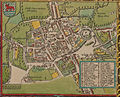
It was with the encouragement of William Camden that Speed began his Historie of Great Britaine, which was published in 1611.[11][12] Although he probably had access to historical sources that are now lost to us (he certainly used the work of Saxton and Norden), his work as a historian is now considered secondary in importance to his map-making, of which his most important contribution is probably his town plans, many of which provide the first visual record of the British towns they depict.[13]

His atlas The Theatre of the Empire of Great Britaine was published in 1611 and 1612, and contained the first set of individual county maps of England and Wales besides maps of Ireland and a general map of Scotland.[15][16] With maps as "proof impressions" and printed from copper plates, detail was engraved in reverse with writing having to be put on the map the correct way, while speed "copied, adapted and compiled the work of others," not doing much of the survey work on his own, which he acknowledged.[7] In 2016, the British Library published a book, introduced by former MP Nigel Nicholson and accompanied by commentaries by late medieval and early modern historian Alasdair Hawkyard, which reprinted this collection of maps on the British Isles, showing that Speed had drawn maps of areas ranging from Bedfordshire to Norfolk and Wales.[17]
Most, but not all, of the county maps have town plans on them; those showing a Scale of Passes being the places he had mapped himself. In 1627, two years before his death, Speed published Prospect of the Most Famous Parts of the World which was the first world atlas produced by an Englishman, costing 40 shillings, meaning that its circulation was limited to "richer customers and libraries," where many survive to this day.[18] There is a fascinating text describing the areas shown on the back of the maps in English, although a rare edition of 1616 of the British maps has a Latin text – this is believed to have been produced for the Continental market. Much of the engraving was done in Amsterdam at the workshop of Jodocus Hondius.[18] His maps of English and Welsh counties, often with bordered with custumed figures ranging from nobility to country folk, are often found framed in homes throughout the United Kingdom.[19]
In 1611, he also published The genealogies recorded in the Sacred Scriptures according to euery family and tribe with the line of Our Sauior Jesus Christ obserued from Adam to the Blessed Virgin Mary, a biblical genealogy, reprinted several times during the 17th century. He also drew maps of the Channel Islands, Poland, and the Americas, the latter published only a few years before his death.[20][21][22] On the year of his death, yet another collection of maps of Great Britain he had drawn were published.[23]
After his death, in 1676, some of his other maps on the British isles, the Chesapeake Bay region, specifically of Virginia and Maryland, the East Indies, the Russian Empire then ruled by Peter the Great, Jamaica, and Barbados, among other locations.[24][25][26][27][28][29][30] Other maps published posthumously ranged from areas such as Great Britain, Channel Islands, [31][32][33] With these printings and others, Speed's maps became the basis for world maps until at least the mid-eighteenth century, with his maps reprinted many times, and serving as a major contribution to British topography for years to come.[8] Even today, prints of his "beautiful maps" can be found in living rooms across the world, and sell or hundreds of thousands of pounds in rare art and map auctions, drawing in map collectors across the globe.[34]
Maps
-
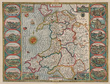 Speed's 1610 map of Wales
 -
 An example of an insert from Speeds 1610 map of Wales
 -
 The Countie Pallatine of Lancaster described and divided into hundreds, 1610
 -
-
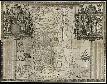
 Wilshire, 1610 with a townplan of Salisbury and a view of Stonehenge
 -
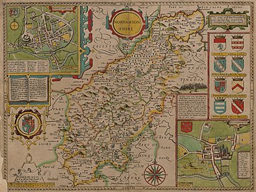 Northamptonshire, 1610
 -
 A New Mape of Ye XVII Provinces, 1626 (The Netherlands)
 -
 The Kingdome of China, 1626
 -
 A New And Accvrat Map of the World, 1646 miniature edition
 -
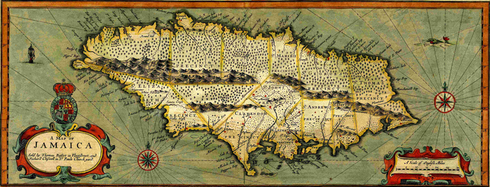 Jamaica, 1676


.png)
Town inserts
-
 Bedforde, 1611
 -
 Dubline, 1610; an 1896 reprint
 -
 Monmouth, 1610
 -
 Oxford, 1610
 -
 Redding, 1610
 -
 Bangor, 1610
 -
 Brecon, 1610
 -
 Cardiff, 1610
 -
 Montgomery, 1610
 -
 St David's ,1610
.jpg)


Footnotes
- Notes
- References
- ^ Baynton-Williams, Ashley. "John Speed". MapForum.Com. Retrieved 17 September 2012.
- ^ "Maps by John Speed". Jonathan Potter Limited. Archived from the original on 3 March 2012. Retrieved 17 September 2012.
{{cite web}}: Unknown parameter|deadurl=ignored (|url-status=suggested) (help) - ^ Intriguing History, "John Speed Maps Online," 2017.
- ^ Major-General William Roy, co-founder of the Ordnance Survey and earlier Christopher Saxton also contend for the most famous status. The word cartography refers to the 'drawing of the charts of maps' and derives from the French carte, card or chart, and Greek graphia, writing. Although it is a useful term ... it is important to note that the word was only coined around 1859 and therefore was not used by the Ordnance Survey's earliest writers and readers.
- ^ Hewitt, Rachel (2010). Map of a Nation. London: Granta Publications. pp. xxvi. ISBN 978-1-84708-254-1.
- ^ "The Life of John Speed". JohnSpeedMaps.co.uk. Retrieved 17 September 2012.
- ^ a b c d e Anne Taylor, "A Theatre of Treasures," Cambridge University Library Special Collections, October 11, 2016.
- ^ a b The Maps of John Speed, Shakespeare's England, August 10, 2010.
- ^ "Heritage". St Giles' without Cripplegate. Retrieved 17 September 2012.
- ^ Hibbert, Christopher; Ben Weinreb; John Keay; Julia Keay. (2010). The London Encyclopaedia. London: Pan Macmillan. p. 762. ISBN 978-0-230-73878-2.
{{cite book}}: CS1 maint: multiple names: authors list (link) - ^ . Dictionary of National Biography. London: Smith, Elder & Co. 1885–1900.
- ^ John Speed proof maps, Cambridge University, Accessed April 5, 2017.
- ^ Nigel Nicholson, "Introduction" within John Speed, Britain's Tudor Maps: County by County (London: British Library, reprint, 2016, originally published in 1988), p. 7-15.
- ^ "Biography John Speed II". MapForum.com. 3. 2006.
- ^ Speed, Britain's Tudor Maps, p. 9-10, 13, 15-16. Nicholson's introduction goes from pages 7 to 15. Speed took a number of existing maps as his models, crediting five of the maps to Christopher Saxton, five to John Horden], two to William Smith, one to Philip Symonson and others to John Harington, William White, Thomas Durham, James Burrell, and Geradus Mercator. For these maps, his engraver was a man by the name of Jodocus Hondius, major engraver at the time, his printers were William Hall and John Beale, and his map-sellers were John Sudbury and George Humble.
- ^ Andrew, "Speed maps now in the Cambridge Digital Library," Cambridge University Library Special Collections, March 23, 2015.
- ^ Speed, Britain's Tudor Maps, p. 6-152. Speed's maps were of areas including the British Isles, England, the Saxon Heptarchy, Berkshire, Buckinghamshire, Cambridgeshire, Cheshire, Cornwall, Cumberland, Derbyshire, Devonshire, Dorset, Durham, Essex, Gloucestershire, Hampshire, Isle of Wight], Herefordshire, Hertfordshire, Huntingtonshire, Kent, Lancashire, Leicestershire, Lincolnshire, Middlesex, Monmouthshire, Northamptonshire, Northumberland, Oxfordshire, Rutland, Shropshire, Somerset, Staffordshire, Suffolk, Surrey, Sussex, Warwickshire, Westmoreland, Wiltshire, Worcestershire, Yorkshire (different parts), Holy Island, the Farne Islands, the Channel Islands, Isle of Man, Wales, Anglesey, Breconshire, Caernarfonshire, Cardiganshire, Carmarthenshire, Denbighshire, Flintshire, Glamorganshire, Merionethshire, Montgomeryshire, Pembrokeshire, Radnorshire, Scotland, Ireland, Connaught, Leinster, Munster, and Ulster.
- ^ a b Nigel Nicholson, "Introduction" within Speed, Britain's Tudor Maps, p. 15.
- ^ Speed, Britain's Tudor Maps, p. 18-21.
- ^ Library of Congress,America with those known parts in that unknowne worlde both people and manner of buildings, 1626.
- ^ Library of Congress catalog, The ilands, London. Are to be solde in Popes Heade Alley by Iohn Sudb. and G. Humbell, 1610.
- ^ Library of Congress catalog, newe mape of Poland, 1611.
- ^ Library of Congress catalog,A prospect of the most famovs parts of the vvorld, London, Printed by John Dawson for G. Humble, 1627.
- ^ 1676 John Speed and F. Lamb Map of Virginia and Maryland (Chesapeake Bay), Geographicus Rare Antique Maps, 2017.
- ^ Antique Maps Online, John Speed Maps - Antique 17th Century, 2017.
- ^ Heritage Publishing, "John Speed Maps," 2017.
- ^ Welland Antique Maps & Prints, "[Published in John Speed's 'Theatre of the Empire of Great Britaine' between 1611 & 1676 and Henry Overton's 'England Described' from c.1713 to c.1756](http://wellandantiquemaps.co.uk/catalog/john-speed-maps)," 2014.
- ^ Mapseeker,"John Speed County Maps, 2014.
- ^ Ebth, "John Speed Original 1676 Map "The Province of Mounster"", 2013-2017.
- ^ Baumann Rare Books, "Map of Huntington both Shire and Shire Towne," 2017.
- ^ Library of Congress catalog, An epitome of Mr. John Speed's Theatre of the Empire of Great Britain, London, Printed for T. Basset, and R. Chiswell, 1676.
- ^ Library of Congress catalog, An epitome of Mr. John Speed's Theatre of the empire of Great Britain, London : Printed for Tho. Basset ... and Ric. Chiswell ..., 1676.
- ^ Charles Edwin Puckett, "‘’A MAP OF RUSSIA’’ c 1676 - John Speed," 1676.
- ^ Steven Morris, John Speed's atlas could take auctioneer into uncharted territory, ''The Guardian'', July 19, 2011.
Further reading
- Johan Speed, Nigel Nicolson (introduction), The Counties of Britain: A Tudor Atlas, Thames & Hudson (1989): ISBN 0-500-25104-5; Pavilion Books (1992): ISBN 1-85145-131-5 (pbk, 1995): ISBN 1-85793-612-4
External links
- Zoomable digital reproduction of a 1611/12 proof of Speed's atlas held at Cambridge University Library
- Online maps by John Speed; Occidental College Library, Los Angeles
- Online maps by John Speed; Barry Lawrence Ruderman Antique Maps Inc.
- Antique Maps, with information about John Speed
- John Speed Wikisource
- Stanford Libraries collection of John Speed and John Ogilby, 15-16th Century Cartographers
| International | |
|---|---|
| National | |
| Academics | |
| Artists | |
| People | |
| Other | |
- 1542 births
- 1629 deaths
- English cartographers
- 16th-century cartographers
- 17th-century cartographers
- People of the Tudor period
- Burials at St Giles-without-Cripplegate
- People from Cheshire
- 16th-century English writers
- English historians
- 16th-century historians
- 17th-century historians
- 17th-century English writers
- English male writers