Alex (Haute-Savoie)
| Alex | ||
|---|---|---|
|
|
||
| region | Auvergne-Rhône-Alpes | |
| Department | Haute-Savoie | |
| Arrondissement | Annecy | |
| Canton | Faverges | |
| Community association | Vallées de Thônes | |
| Coordinates | 45 ° 53 ' N , 6 ° 14' E | |
| height | 516-1,852 m | |
| surface | 17.02 km 2 | |
| Residents | 1,072 (January 1, 2017) | |
| Population density | 63 inhabitants / km 2 | |
| Post Code | 74290 | |
| INSEE code | 74003 | |
| Website | www.alex-village.com | |
Alex is a French commune in the department of Haute-Savoie in the region of Auvergne Rhône-Alpes .
geography
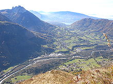
Alex is located at 592 m , about 9 km east of the city of Annecy (as the crow flies). The former farming village extends in a basin of the Fier on the southern edge of the valley on both sides of the village stream Nant d'Alex, in the Bornes Alps at the foot of the Dent du Cruet.
The area of the 17.02 km² municipal area covers a section of the Bornes Alps. The northern border runs along the Fier, which flows here from east to west through a basin and then breaks through the chain of the Bornes Alps in the deeply cut Klus Défilé de Dingy . The main settlement area forms the depression running across the valley of the Fier between the river and the saddle of the Col de Bluffy ( 630 m ). This depression is flanked to the west by the ridge of Mont Baret ( 1243 m ).
The community area extends to the south and south-east into the heavily reliefed area of the Tournette massif . The catchment area of the Nant d'Alex torrent belongs to the municipality. It is bordered by the prominent rock peaks of the Dents de Lanfon ( 1824 m ), the height of Larrieux (at 1850 m, the highest elevation of Alex) and the Dent du Cruet ( 1833 m ).
In addition to the actual center of Dingy, Alex also includes various hamlet settlements and farms, including:
- Le Pont ( 560 m ) in the Fier valley
- Belossier ( 625 m ) at the eastern foot of Mont Baret
- Villards Dessous ( 680 m ) on the slope above the village
- Villards Dessus ( 750 m ) on a ledge on the northern slope of the Dents de Lanfon
Neighboring municipalities of Alex are Dingy-Saint-Clair in the north, La Balme-de-Thuy and Thônes in the east, Talloires , Bluffy and Menthon-Saint-Bernard in the south and Veyrier-du-Lac and Annecy-le-Vieux in the west.
Attractions
The parish church of Alex was built in the neo-Gothic style and underwent extensive restoration in the early 1990s. The castle dates from the 13th century. It belonged to the lords of Les Clefs and from 1383 to the Arenthon family, who held it until a few years before the French Revolution. Today the castle houses a foundation for contemporary art.
population
| Population development | |
|---|---|
| year | Residents |
| 1962 | 261 |
| 1968 | 246 |
| 1975 | 268 |
| 1982 | 429 |
| 1990 | 574 |
| 1999 | 792 |
With 1072 inhabitants (as of January 1, 2017) Alex is one of the small communities in the Haute-Savoie department. In the course of the 19th and 20th centuries, the number of inhabitants decreased continuously due to strong emigration (in 1861 there were still 803 inhabitants in Alex). Since the mid-1970s, however, a marked increase in population has been recorded.
Economy and Infrastructure
Until well into the 20th century, Alex was a predominantly agricultural village. Today there are various small and medium-sized businesses. An industrial zone has developed in the valley in which, among other things, wood processing, precision mechanics and a sporting goods manufacturer have settled. Otherwise the village has developed into a residential community. Many workers are also commuters who work in the Annecy area.
The village is very well developed in terms of traffic. It is close to the D909 departmental road from Annecy to Thônes . Further road connections exist with Annecy-le-Vieux and Dingy-Saint-Clair. The closest connection to the A41 motorway is around 15 km away.

