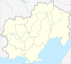
Arman (Russia)
| settlement
Arman
Армань
|
||||||||||||||||||||||||||||||
|
||||||||||||||||||||||||||||||
|
||||||||||||||||||||||||||||||
Arman ( Russian А́рмань ) is a settlement in the Magadan Oblast ( Russia ) with 1071 inhabitants (as of October 14, 2010).
geography
The place is about 40 km as the crow flies west-northwest of the Magadan Oblast Administrative Center on the coast of the Sea of Okhotsk , on the Amakhtonski Bay (Amakhtonski Saliw), part of the larger Taui Bay . Immediately to the east flows the eponymous river Arman , which in turn flows into the largest tributary Chassyn only about 5 km above to the left (east) .
Arman belongs to the Olski district and is located almost 70 km west of its administrative center Ola . The settlement is the seat of the municipality (gorodskoje posselenije) Possjolok Arman, which also includes the small settlements Janski (35 km west-northwest, named after the Jana river ) and Raduzhny (4 km north).
history
An Ewenian settlement in the place of today's place was mentioned in Russian documents of the late 17th century. The name of the place and river is of Ewenian origin and means, among other things, spring.
During the Soviet period, a fishing, hunting and agricultural cooperative was established there, which was converted into one of the most important collective farms in the region in 1932 . In 1965 Arman was given urban-type settlement status , but has been a rural settlement again since 2013.
Population development
| year | Residents |
|---|---|
| 1970 | 2188 |
| 1979 | 2653 |
| 1989 | 2643 |
| 2002 | 1521 |
| 2010 | 1071 |
Note: census data
traffic
Arman is on the regional road R481, which north of Magadan from the R504 Kolyma Magadan - Nizhny Bestjach near Jakutsk (previously M56 , number still in use until 2017), coming first along the coast to Tauisk and then up the river Taui to the village of Talon follows.
Individual evidence
- ↑ a b Itogi Vserossijskoj perepisi naselenija 2010 goda. Tom 1. Čislennostʹ i razmeščenie naselenija (Results of the All-Russian Census 2010. Volume 1. Number and distribution of the population). Tables 5 , pp. 12-209; 11 , pp. 312–979 (download from the website of the Federal Service for State Statistics of the Russian Federation)
- ↑ Arman on the website kolyma.ru (Russian)
- ↑ Order No. 147 of the Magadan Oblast Administration of February 28, 2013 (Russian)

