
Bagan
| ပုဂံ Bagan |
|||
|---|---|---|---|
|
|||
| Coordinates | 21 ° 10 ′ N , 94 ° 52 ′ E | ||
| Basic data | |||
| Country | Myanmar | ||
| Mandalay region | |||
| District | Nyaung U | ||
| ISO 3166-2 | MM-04 | ||
| Residents | 22,000 | ||
 |
|||


Bagan [ bəgàn ] ( Burmese ပုဂံမြို့ Pugan Myahoet , "city of Bagan", also Arimaddana or Arimaddanapura, "city breaker of enemies", and Tambadipa, "copper country" or Tassadessa, "parched land") is a historic royal city in Myanmar with over two thousand preserved sacred brick buildings. The area made up of temples extends over approx. 36 km² in a stepped landscape and forms one of the largest archaeological sites in Southeast Asia . Bagan is located in what is now the Mandalay Division , 155 km southwest of the city of Mandalay on the east bank of the Irrawaddy , halfway between its source and its mouth in the Indian Ocean and is now one of the most important tourist destinations in Myanmar.
history

The kingdom, whose rulership was Bagan for about 430 years, formed the first unified empire in what is now Burma . The details of the early history of Bagan are debatable. Due to its extremely favorable location on the Irrawaddy , where trade routes from China and India met, Bagan became the central town of Oberbirmas as early as the middle of the 9th century, although before the 11th century disputes over the throne and dynasty changes caused many phases of instability. The city was surrounded by a wall by the king in 849. Already at this time, Tantrism or Vajrayana Buddhism , which came from India, and the local snake cult began to mix. Two closed settlements of Indian-Bengali immigrants from the 9th / 10th centuries were found near the former city wall. Excavated in the 16th century.
Rise and flowering period

However, the localization of great power in Bagan only came about with the accession to the throne of King Anawrahta (also Anuruddha ) in 1044. Specifically, Anawratha was won over to Buddhism by a Mon monk and in 1056 drove the priests of the indigenous serpent cult from the capital. Under him and his son Kyanzittha (1084–1113) the city reached its prime. During the rule of these two kings, Theravada Buddhism became a hegemonic religion and an instrument for maintaining power in competition with old local faith groups .
The empire expanded under Anawrahta from the arid zone in the north to the subdued Mon centers of Pegu ( Bago ) and Thaton in the Irrawaddy Delta. Anawrahta asked the Mon king Manuha of Thaton for monks and holy scriptures to instruct his people. But he did not follow the request and so he was attacked. In 1057 Anawratha conquered the Thaton Empire and had the entire Mon oligarchy brought to Bagan with its kings and queens. This is how Buddhism spread to Bagan.
The expansion of the rulership of Bagan to about the size of today's territory of Burma opened up the rulers of Upper Burma with material and cultural resources that were previously unknown. With the deportation of the entire Mon educational elite to Bagan, the Mon script and its literary culture were adopted. With an area of 40 km², Bagan grew into one of the largest cities of the Middle Ages and was therefore around 15 times larger than the medieval City of London .
The ruler also expanded his political and religious relationships by sea to and from Ceylon .
The state was modeled on the Hindu kingdoms. The based in the capital royal court was the taxation of individual households or compulsory labor in from Myothugis funded (manager of settlements with hereditary rights) governed villages. Over time, increasingly larger parts of the country were made available to Buddhist monasteries in the form of so-called slave villages to maintain monasticism ( Sangha ). Kingship was also legitimized by the king's role as defender of Buddhism . During the 250 year period of peace, the pious rulers had almost 6000 pagodas built, of which around 2000 have been preserved and for which Bagan is famous today.
Decline
Like the rise, the fall of the Bagan Empire is related to the combination of secular and spiritual power. The cost of building temples and maintaining the staff were one reason the state was weakened. In addition to the tax exemption of temples and monasteries, more and more governors in the conquered provinces withheld taxes from the middle of the twelfth century and thus deprived the state of its financial foundation.
So weakened, the Burmese had hardly anything to oppose the Thai and Mongols, who were pushing into their territory from the north . King Narathihapate (ruled 1256–1287) came into conflict with the Mongol-ruled Yuan China . Before the army of the Mongol prince Kublai Khan took the city in 1287, the ruler of Bagan had many temples torn down to build a city wall. With the flight of the king from the Mongols, the myth of Bagan as a bridge between heaven and earth was finally destroyed.
The empire between the southern foothills of the Himalayas and the Indian Ocean, previously ruled from Bagan , disintegrated for more than two centuries into numerous small states that constantly fought each other. In the centuries that followed, Bagan was unable to maintain its former importance as the capital.
Upper Burma led an uncertain existence between the supremacy of the Shan , who z. B. 1299 killed a king of Bagans, and tributary relations with China , while Sub-Company again came under the rule of the Mon (with the capital Pegu, today Bago ).

geography
The so-called Bagan Archaeological Zone extends over an area of about 13 × 8 kilometers, which extends around Old Bagan and includes Nyaung U in the north and New Bagan in the south. Bagan belongs to the Mandalay Division and is located about 150 km southwest of Mandalay on the Irrawaddy .
Buildings


- Abeyadana Temple , built under Kyanzittha, 1102/1103
- Ananda temple
- Bupaya Pagoda
- Dhammayangyi Temple , largest temple in Bagan
- Dhamma-yazika
- Gawdawpalin Temple
- Gubyaukgyi Temple
- Htilominlo Temple , around 1218
- Kyauk Gu Umin Temple
- Lokananda , built under Anawrahta
- Lemyethna Temple
- Manuha Temple , 11th century
- Mingalazedi
- Nandamannya Temple
- Nanpaya temple , Mon style
- Nat Hlaung Kyaung Temple
- Nat Htaunk Kyaung Monastery
- Ngakywenadaung stupa
- Payathonzu Temple
- Pitakat Taik , library
- Pyathada temple
- Sein-nyet Ama and Nyima, temple and pagoda, 13th century
- Shwegugyi Temple
- Shwe-hsan-daw , built under Anawrahta
- Shwezigon , built under Anawrahta
- Sulamani Temple , 1183
- Tan-chi-daung, built under Anawrahta
- Tayokpye Temple
- Thambula temple
- Thamya temple
- Tharaba city gate
- Thatbyinnyu Temple , 12th century, 61 m high, two-story with three terraces each and miniature stupas
- Tu-win-daung, built under Anawrahta
- U Pali Thein , ordination hall
concept
The rulers of Bagan tied their power closely to the Buddhist faith . Using its symbolism to maintain power, they redesigned the layout of the city center of Bagan to reflect the center of the Buddhist cosmos. The square that was destroyed today by the meandering of the Irrawaddy stood for the mountain of the gods Meru . Divided into nine fields, the eight outer parts represent the previously known eight planets of the solar system. The ninth, the central field, is reserved in Buddhist mythology for Gautama Buddha himself. Here King Anawrahta built his palace and the Mahabodhi temple.
The Theravada Buddhism is also the driving force for the planar development of the city. As in the race for the favor of the gods, without considering the immense costs, temples, pagodas and monasteries were built from the clay and decorated with sandstone, glazed panels and stucco . This is the only way to explain the large number of sacred buildings that were erected in just two hundred years. The fact that the ruins of Bagan seem so extensive today is due to the fact that only sacred buildings were built from stone. The construction of residential buildings, however, was made of less permanent materials such as wood and bamboo and resulted in the desertification of the area around Bagan.
Restoration work


Today Bagan is one of the largest archaeological sites in Southeast Asia. In addition to the primarily architecturally interesting monuments, there are wall paintings from the 11th to the 13th century, the oldest surviving paintings in Southeast Asia , some of which have been excellently preserved due to the extremely dry climate in Bagan.
The measures to register and restore the historical building stock began many years before the military came to power in 1962. As early as 1958, the Burmese Institute of Archeology made a copy of the inscriptions on the walls of the Ananda Temple . The Burmese Historical Commission followed in 1962 with the aim of capturing the paintings in photographs. The inscriptions were severely damaged for the first time when a glycerine coating was applied to improve the colors and then removed by ants. A new reconstruction with the most modern restoration techniques became impossible after the severe earthquake in 1975. The epicenter of the earthquake, with a magnitude of 6.5 on the Richter scale, was in Bagan. It also destroyed or damaged many other surviving temples and statues.
The reconstruction measures in Bagan are not limited to small-scale work. In the meantime, entire temples that collapsed in the 1975 quake and were partially removed are being rebuilt from new bricks and concrete, while others are being completely rebuilt. Historical building plans and styles are hardly taken into account. The building measures of the ruling generals are primarily symbolic. They should demonstrate their piety to the population and place their power of government in line with the great rulers of the Bagan period.
The earthquake of August 24, 2016 with a magnitude of 6.8 (7) with an epicenter about 40 km southwest of Bagan caused significant damage to the temples.
World Heritage
| Bagan | |
|---|---|
|
UNESCO world heritage |
|
| National territory: |
|
| Type: | Culture |
| Criteria : | (iii) (iv) (vi) |
| Surface: | 5005 ha |
| Buffer zone: | 18147 ha |
| Reference No .: | 1588 |
| UNESCO region : | Asia and Pacific |
| History of enrollment | |
| Enrollment: | 2019 ( session 43 ) |
After many years of restoration work, Bagan was added to the UNESCO World Heritage List in July 2019 as the second site in Myanmar .
Views

South gate tower of the Ananda Temple

Sulamani temple

The Ananda Temple

Buddha in Bhumisparsha mudra : gesture of invoking the earth

Bagan at sunset
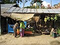
market
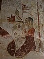
Fresco in Sulamani Temple

Buddha with diamonds in Alodawpyi Pagoda

Buddha in Gawdaw Palin


Ruler of Bagan

Before 1044
According to Burmese chronicles:
- Pyusawti (since 167)
- Timinyi , son of Pyusawti (since 242)
- Yimminpaik , son of Timinyi (since 299)
- Paikthili , son of Yimminpaik (since 324)
- Thinlikyaung , son of Paikthili (since 344)
- Kyaungdurit , son of Thinlikyaung (since 387)
- Thihtan , son of Kyaungdurit (since 412)
- 439–494 different usurpers
- Tharamunhpya , great grandson of Thihtan (since 494)
- Thaiktaing , son of Tharamunhpya (since 516)
- Thinlikyaungnge , son of Thaiktaing (since 523)
- Thinlipaik , brother of Thinlikyaungnge (since 523)
- Hkanlaung , brother of Thinlikyaungnge (since 547)
- Hkanlat , brother of Thinlikyaungnge (since 557)
- Htuntaik , son of Hkanlat (since 569)
- Htunpyit , son of Htuntaik (since 582)
- Htunchit , son of Htunpyit (since 598)
- Popa Sawrahan , priest usurper (since 613)
- Shwe Onthi , son-in-law of Popa Sawrahan (since 640)
- Peitthon , brother of Shwe Onthi (since 652)
- Ngahkwe , son of Peitthon (since 710)
- Myinkywe , usurper (since 716)
- Theinkha , of royal blood (since 726)
- Theinsun , son of Theinkha (since 734)
- Shwelaung , son of Theinsun (since 744)
- Htunhtwin , son of Shwelaung (since 753)
- Shwemauk , son of Htunhtwin (since 762)
- Munlat , brother of Shwemauk (since 785)
- Sawhkinhnit , son of Munlat (since 802)
- Hkelu , son of Sawhkinhnit (since 829)
- Pyinbya , brother of Hkelu (since 846, founder of Bagan, 849)
- Tannet , son of Pyinbya (since 878)
- Sale Ngahkwe , usurper (since 906)
- Nyaung-u Sawrahan , usurper (since 931)
- Kunhsaw Kyaunghpyu , son of Nyaung-u Sawrahan (since 964)
- Kyiso , son of Kunhsaw Kyaunghpyu (since 986)
- Sokka-te , brother of Kyiso (since 992)
The Bagan Dynasty
The year of accession to the throne in brackets
- Anawrahta (1044)
- Sawlu , son of Anawrahta (1077)
- Kyanzittha , son of Anawrahta (1084)
- Alaungsithu , great grandson of Kyanzittha (1113)
- Narathu , son of Alaungsithu (1167)
- Naratheinkha , son of Narathu (1170)
- Narapatisithu , brother of Naratheinkha (1173)
- Nantaungmya (Htilominlo), son of Narapatisithu (1210)
- Kyaswa , son of Nantaungmya (1234)
- Uzana , son of Kyaswa (1250)
- Narathihapate (Tarokpyemin), son of Uzana (1254)
- Kyawswa , son of Narathihapate (1287)
- Sawhnit , son of Kyawswa (1298)
- Uzana , son of Sawhnit (1325)
See also
literature
- Michael Aung-Thwin: Pagan. The Origins of Modern Burma. University of Hawaii Press, Honolulu HI 1985, ISBN 0-8248-0960-2 .
- Tilman Frasch: Pagan: Stadt und Staat (= contributions to South Asian research. Vol. 172) Steiner, Stuttgart 1996, ISBN 3-515-06870-8 (at the same time: Heidelberg, University, dissertation, 1994).
- Gordon H. Luce: Old Burma - early Pagán. 3 volumes. Augustin, Locust Valley NY 1969.
- Nina Oshegowa, Sergej Oshegow: Art in Burma. 2000 years of architecture, painting and sculpture under the sign of Buddhism and animism. EA Seemann, Leipzig 1988, ISBN 3-363-00054-5 , pp. 35-183.
- Sujata Soni: Evolution of Stupas in Burma. Pagan Period: 11th to 13th centuries AD (= Buddhist Tradition Series. 12). Motilal Banarsidass, Delhi et al. 1991, ISBN 81-208-0626-3 (also: Mandalay, University, dissertation, 1969).
- Paul Strachan: Pagan. Art & Architecture of Old Burma. 2nd UK edition. Kiscadale Publications, Oxford 1996, ISBN 1-870838-85-8 , pp. 59-61.
Web links
- Bagan on the UNESCO World Heritage Center website ( English and French ).
- Photos and information about Bagan at 22places
- Reconstructing History: Pagan Gets a Facelift ( Memento from February 26, 2007 in the Internet Archive ) (February 2007)
- The Pagan Period: Burma's Classic Age ( Memento from June 14, 2006 in the Internet Archive ) (June 2006)
Individual evidence
- ↑ Oliver Holms, Myanmar struck by 6.8-magnitude earthquake on The Guardian, August 24, 2016, accessed on August 24, 2016
- ↑ https://www.deutschland.de/de/topic/kultur/welterbe-hilfe-fuer-die-tempelstadt-von-bagan-in-myanmar
- ↑ https://whc.unesco.org/en/list/1588
