
Landmark
_in_Pehlen.jpg)
A boundary stone (also a marking , landmark or banstone ) is a common marking of boundary points ( corner points , kinks or nodes ) of a parcel boundary . Boundary stones are visible for local identification, but are set flush with the floor in the boundary point, usually with an average positional accuracy of a few centimeters. But with field and forest boundaries they can also project some decimeter from the ground in order for farmers when plowing to be clearly visible (here longer stones are mostly used as usual). In the past, so-called running stones were set within very long boundaries (usually every 100 m).
Indirect labeling

If a boundary point cannot be marked directly, a boundary symbol can also be set as an indirect or indirect marking in one of the boundaries that extend from the boundary point (at a short distance, e.g. one meter). At national borders, a Weiser or Weiserstein can also indicate a more distant border point, for example due to overbuilding, on river banks and in mountainous areas. Indirect marking is also possible if an exact boundary stone would hinder work, for example in agriculture.
Original boundary stones
In difficult terrain and usage conditions, original boundary marking solutions are used:
- Hose football field in Wiechs : Germany / Switzerland border on the sideline of the football field is marked by a stone slab at ground level.
- Hochrheinbahn Singen - Schaffhausen : the border is marked by a plate at ground level in the railway gravel.
- The course of the border in the middle of the Rhine between the exclave of Büsingen and Switzerland: The point is documented by a boulder placed on the river bed.
history


Boundary stones were initially used to mark sacred peace areas. This tradition of marking a border spread across Europe . When a boundary encompassed a certain legal area, it was made visible by boundary stones. The stones, which were considered legally binding, were under special protection. This protection is already mentioned in early popular rights and also in medieval legal collections. Responsibility for the regular border inspections and correct stone setting was incumbent on the field jurors . The early boundary stones were initially composed of a main stone and smaller side stones, the " witnesses ". The "witnesses" had the task of marking the stone as a deliberately placed boundary stone. At the beginning they were built on the two plots to be separated , later they were set in the border direction. Often objects were placed under the main stone (so-called boundary stoneware ), which should guarantee the authenticity of the stone. A single stone had no evidential value, it had to be lined with other stones or objects.
In the 13th century, stones began to be worked rough and used as border markings. These stones were usually brought into an elongated shape. The demarcation of the high court districts ultimately meant that the boundary stone has prevailed as a boundary marker. Another factor was the rural population's interest in clearly marking the streets and commons . Private and shared usage rights should be separated from one another and at the same time protected against attacks. Furthermore, the different municipal areas should be delimited from each other, which was strengthened by population growth, the establishment of cities and urban expansion. In the 14th and 15th centuries, the boundary stone also found its way into the demarcation of sovereign and legal borders. More and more boundary stones were also set at property boundaries.
If a boundary stone marks the meeting of not just two, but three or four demarcations , one speaks of a three or four markers . In these cases the stones show corresponding boundaries in three or four parts. Sometimes you can find chippings or whet marks on them, because the material of a three or four-markers was previously thought to have a magical effect and therefore parts of these stones were scraped or knocked off in order to take them away.
From the 16th century, the boundary stone was used in economically developed areas on all types of border. At this time the border tree is also supplemented by the border stone. In densely populated areas, the boundary stone displaced walls, hedges or fences, which previously made the boundaries visible. Even after the Thirty Years' War , borders were again provided with boundary stones. This type of border marking has survived to this day.
As Fischerei-Föhrte stones from the 16th to the beginning of the 20th century and partly still preserved boundary stones are known, by means of which in the course of the Lower Elbe in the area of the offices Winsen (Luhe) and Harburg (on the southern bank of the Elbe) and In the area of the Bergedorf Office (on the northern bank of the Elbe) the fishing rights on the Elbe were regulated by dividing the river into different fish fjords . Also on the Elbe, so-called cable stones were used to define dyke sections ( cables ) of different sizes , "which were to be maintained by certain residents of the Bailiwick Neuland [in the Winsen (Luhe) ] office and defended by these people if the dike was at risk".
Boundary stones were also used to mark forest ownership and thus to mark forest boundaries . From the 15th century z. B. the oldest preserved row of boundary stones in the rose garden , then located in the Harburg district and belonging to the Principality of Lüneburg . In the course of forestry reforms from the 18th to the 19th century, forest boundary stones were set not only here, but also to delimit other manorial forest areas in the then Electorate of Braunschweig-Lüneburg or later Kingdom of Hanover . Characteristic of these newer boundary stones is, in addition to a numbering, in particular the wolf fishing sign as a forest or rule symbol of the sovereign in the forestry context. Only a few initial stones in a row of boundary stones contain, in addition to number 1, the monogram of the elector ( Georg II. Or Georg III. ) (See also historical boundary stones in the beginning of Gellers and archeology in the rose garden) .
nature

Modern boundary stones are usually made of granite or concrete with a cross on top. However, markings made of plastic (e.g. marking stones made of recycled material) or iron pipes with a plastic mark on them are also used.
Older markings can also be hewn or uncut natural stones without a cross. Often there are also boundary stones on which the actual boundary line is shown by means of a chiseled notch (instruction). At corner or kink points, angled lines can also be found, at some border nodes also stylized borderline courses in the form of a "T" or "Y". The rock types available in the region were used. There are those made of granite , limestone , marble , sandstone , slate , basalt columns and other types. With limits in alpine terrain, the boundary markers (crosses, lines, arms and dates) were a rock March often carved in the bedrock or in separately growing, large rocks.
There are still numerous historical, artistically executed boundary stones with coats of arms or inscriptions on the boundaries of country estates or stately forests . Boundary stones were also set to mark church property.
Modern forms

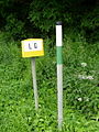
Instead of boundary stones - depending on the local conditions (as well as in Germany depending on the federal state-dependent surveying regulations) - other types of marking are also used. In urban or built-up areas, these are mainly: boundary mark with screw thread, tube with plastic cap, chisel cross, steel nail or brass bolt, mostly with the inscription “Grenzpunkt”. Occasionally, instead of being brought in in rem, there is only a cross marking in the road curb . In recent times, plastic boundary stones have also been used in some cases. Before the completion of an ongoing survey, provisional signs ( day marks ) such as wooden pegs or poles (including escape poles ) are also used.
The method of providing boundary stones with so-called “underground security”, “ submarking ” or “witnesses” has survived to this day. These can consist, for example, of a glass bottle with the neck down , a clay cone or a conical plastic mark ( carrot ) under the boundary stone. Clay witnesses were also used in many regions. These are mostly rectangular or triangular clay discs with the coat of arms of the district on it. These witnesses should enable a restoration of important borders or testify the correctness of the boundary stone, if the stone z. B. is torn out by the plow . For higher accuracy requirements of the witness can with the theodolite or a batter be abgelotet.
Legal regulations
In Germany, according to Section 274 of the Criminal Code, the removal, obscuring or relocation of a boundary stone with the intention of causing harm to another person is threatened with a fine or imprisonment of up to five years. The unauthorized modification or removal of boundary marks is also an administrative offense according to the land surveying and cadastral laws of the federal states .
Historic Landmarks are today as cultural monuments ( small monuments ) under monument protection .
In Baden-Württemberg , with the surveying law of 2004, the obligation to mark, i.e. the setting up of boundary stones, was no longer necessary.
Photos of modern border stamps
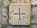
Granite boundary mark (15 cm × 15 cm) with a cut-in cross, Berlin-Spandau

Concrete boundary sign with hole and lettering
Modern border markings - the state border between Thuringia and Saxony near Windischleuba
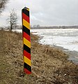
Modern state border marking - border between Germany and Poland near Frankfurt (Oder) on Ziegenwerder

Border post in Baarle

Baarle: Pavement landmarks next to a street café

Baarle: Pavement boundary stones - the border leads through a house

Border stone 147 at Haldenwanger Eck , the southernmost point of Germany, border triangle Bavaria / Vorarlberg / Tyrol , erected in 1986


_33_Grenzmarkierung.jpg)


Examples of historical landmarks
literature
- Brandner, Josef and Spichtinger, Heinrich: Around the Landl - Alt Werdenfelser boundary stones and rock marches , adam-verlag Garmisch-Partenkirchen 1993
- Gudelius, Jost: Double abbot staff and Hebscheidt: boundary stones and rock marches between the Benediktbeuern monastery court and the Tölz district court . Schneemann-Verlag, Jachenau, November 1, 2014, ISBN 978-3-9815341-7-7
- Philippi, Nikolaus: Grenzland Hegau: Boundary stones remind of former lords and territories. Rockstuhl Publishing House. ISBN 978-3-86777-479-6
- Philippi, Nikolaus: Landmarks in Germany - Origin and history of the landmarks as stone witnesses in the forest and the field . Rockstuhl Verlag, Bad Langensalza, 2009, ISBN 978-3-86777-125-2
- Schmitt, Roland: Boundaries - on the history, typology and preservation of historical boundary signs made of stone . Edition Überwald published by B. Faber, Mandelbachtal-Heckendalheim, 2003
- Simmerding, Franz: Grenzzeichen, Grenzsetzer and Grenzfrevler . A contribution to cultural, legal and social history. (Eds.) Fried, Pankraz. German Association for Surveying. Munich, 1996.
Web links
- Literature on the keyword Grenzstein in the catalog of the German National Library
- http://bornesfrontieres.lu/ (French) (private site)
Individual evidence
- ↑ Explanations on the Measurement Act, Federal Law Gazette I No. 51/2016
- ^ Nikolaus Philippi: Grenzland Hegau: Boundary stones remind of former rulers and territories. Rockstuhl Publishing House. ISBN 978-3-86777-479-6
- ↑ See Simmerding, Franz: Grenzzeichen, Grenzsetzer and Grenzfrevler . A contribution to cultural, legal and social history. (Eds.) Fried, Pankraz . German Association for Surveying. Munich, 1996. p. 92.
- ↑ See Simmerding, Franz: Grenzzeichen, Grenzsetzer and Grenzfrevler . A contribution to cultural, legal and social history. (Eds.) Fried, Pankraz. German Association for Surveying. Munich, 1996. p. 96.
- ↑ See Simmerding, Franz: Grenzzeichen, Grenzsetzer and Grenzfrevler . A contribution to cultural, legal and social history. (Eds.) Fried, Pankraz. German Association for Surveying. Munich, 1996. p. 97.
- ↑ History and development of the boundary stones. Retrieved January 16, 2020 . (PDF file)
- ↑ See Simmerding, Franz: Grenzzeichen, Grenzsetzer and Grenzfrevler . A contribution to cultural, legal and social history. (Eds.) Fried, Pankraz. German Association for Surveying. Munich, 1996. p. 100.
- ↑ Carsten Paeper: hallway monuments - cultural monuments of the district Harburg. In: Stone Cross Research. No. 12, 1986, p. 38.
- ↑ Carsten Paeper: hallway monuments - cultural monuments of the district Harburg. In: Stone Cross Research. No. 12, 1986, p. 39.
- ↑ a b Forest boundary stones in the rose garden. Retrieved March 25, 2016 .
- ↑ Carsten Paeper: hallway monuments - cultural monuments of the district Harburg. In: Stone Cross Research. No. 12, 1986, p. 34.
- ↑ Tracey Runciman: Landmarks in the rose garden. In: Helms-Museum aktuell. No. 34, September 2014, p. 1. Helms-Museum aktuell, No. 34, September 2014. (PDF) Retrieved on April 13, 2018 .
- ↑ Carsten Paeper: hallway monuments - cultural monuments of the district Harburg. In: Stone Cross Research. No. 12, 1986, p. 38
- ↑ Carsten Paeper: hallway monuments, cultural monuments of the district Harburg. Forest landmarks in the Garlstorfer forest . In: Landkreis Harburg (Ed.): Harburg district calendar. A home book for 1987 . Without tape counting. Lühmanndruck Gustav Schröter + Sons, Hamburg-Harburg 1986, p. 42-43 .
- ^ Bavarian Main State Archives Munich, KL Benediktbeuern 174, marking the fairy tales in June 1584
- ↑ Sabrina Michielli, Hannes Obermair (Red.): BZ '18 –'45: one monument, one city, two dictatorships. Accompanying volume for the documentation exhibition in the Bolzano Victory Monument . Folio Verlag, Vienna-Bozen 2016, ISBN 978-3-85256-713-6 , p. 44 .
- ↑ Berchtesgadener Anzeiger : Guardian of the Boundaries and Markings , from August 24, 2018, accessed on September 18, 2018
- ↑ See e.g. B .: Lower Saxony State Office for the Preservation of Monuments: Monument protection and preservation in Lower Saxony. (PDF; 3.1 MB) Lower Saxony State Office for Monument Preservation, 2015, p. 21 , accessed on March 25, 2017 .
- ↑ Klaus Riexinger: Boundaries are witnesses of lost empires. Badische Zeitung, August 25, 2020, accessed on August 26, 2020 .