
Beersel
| Beersel | |||
|---|---|---|---|

|

|
||
|
|||
| State : |
|
||
| Region : | Flanders | ||
| Province : | Flemish Brabant | ||
| District : | Halle-Vilvoorde | ||
| Coordinates : | 50 ° 46 ′ N , 4 ° 19 ′ E | ||
| Area : | 30.01 km² | ||
| Residents: | 25,251 (Jan. 1, 2019) | ||
| Population density: | 841 inhabitants per km² | ||
| Post Code: | 1650 (Beersel) 1651 (Lot) 1652 (Alsemberg) 1653 (Dworp) 1654 (Huizingen) |
||
| Prefix: | 02 | ||
| Mayor: | Hugo Vandaele ( CD&V ) | ||
Local government address : |
Administratief Centrum, Alsembergsteenweg 1046, 1652 Alsemberg |
||
| Website: | www.beersel.be | ||

Beersel is a Belgian municipality in the province of Flemish Brabant , on the southern edge of the Brussels-Capital Region . It includes the sub-municipalities Alsemberg, Dworp, Huizingen and Lot.
Beersel is best known for its castle complex from the 14th century.
Personalities
- Renaat Van Elslande (1916–2000), politician
- Joseph Wauters (1906–1975), racing cyclist
coat of arms
Description: In black and gold gevierten crest is in the first and fourth field a golden rotgezungter rotbewehrter and Leo , in the second and third field, a blue Mean Cross with mandrel section reaching to all Armseiten to the edge. Behind the sign is an oak tree with eight fruits.
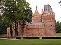
Beersel Castle

Web links
Aarschot | Affligem | Aces | Beersel | Begijnendijk | Bekkevoort | Bertem | Bever | Bierbeek | Boortmeerbeek | Boutersem | This | Dilbeek | Drug bos | Galmaarden | Prayer | Glabbeek | Gooik | Grimbergen | Haacht | Hall | Herent | Herne | Hoegaarden | Hoeilaart | Holsbeek | Huldenberg | Kampenhout | Chapel-op-den-Bos | Keerbergen | Kortenaken | Kortenberg | Kraainem | Landing | Lennik | Lions | Liedekerke | Linkebeek | Linter | Londerzeel | Lubbeek | Machelen | Titmouse | Merchtem | Opwijk | Oud-Heverlee | Overijse | Pepingen | Roosdaal | Rotselaar | Scherpenheuvel-Zichem | Sint-Genesius-Rode | Sint-Pieters-Leeuw | Steenok candle | Ternat | Tervuren | Tielt-Winge | Tienen | Tremelo | Vilvoorde | Wemmel | Wezembeek-Oppem | Zaventem | Zemst | Zoutleeuw