Belina (Slovakia)
| Belina | ||
|---|---|---|
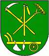
| coat of arms | map | |

|
|
|
| Basic data | ||
| State : | Slovakia | |
| Kraj : | Banskobystrický kraj | |
| Okres : | Lučenec | |
| Region : | Poiplie | |
| Area : | 6.483 km² | |
| Residents : | 625 (Dec. 31, 2019) | |
| Population density : | 96 inhabitants per km² | |
| Height : | 211 m nm | |
| Postal code : | 986 01 ( Fiľakovo Post Office ) | |
| Telephone code : | 0 47 | |
| Geographic location : | 48 ° 15 ' N , 19 ° 51' E | |
| License plate : | LC | |
| Kód obce : | 511234 | |
| structure | ||
| Community type : | local community | |
| Administration (as of November 2018) | ||
| Mayor : | Zoltán Marcinkó | |
| Address: | Obecný úrad Belina Č. 194 98501 Fiľakovo |
|
| Website: | obecbelina.webnode.sk | |
| Statistics information on statistics.sk | ||
Belina (up to 1927 in Slovak “Beňa” or “Biena”, from 1927 to 1948 “Béna”; Hungarian Béna ) is a municipality in southern Slovakia . It is located in the north-western part of the Cerová vrchovina mountain range , 3 km south of Fiľakovo . The vast majority of the population is Hungarian-speaking (around 90 percent of the population in 2001).
The municipality was in 1240 for the first time as terra Baldun mentioned, the place itself emerged in 1371 for the first time in written form as Bezin on. Over the centuries, the residents were mainly active in agriculture. In 1910 410 inhabitants lived in the village. From 1938 to 1945 the place belonged to Hungary due to the First Vienna Arbitration .
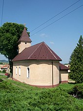
The existing church in the village was built in 1896.

