
Waidhofen an der Thaya district
| location | |
|---|---|
  |
|
| Basic data | |
| state | Lower Austria |
| NUTS III region | AT-124 |
| Administrative headquarters | Waidhofen an der Thaya |
| surface | 669 km² |
| Residents | 25,682 (January 1, 2020) |
| Population density | 38 inhabitants / km² |
| License Plate | WT |
| District Commission | |
| District Captain | Günter Stöger |
| website |
www.noel.gv.at/Bezirke/ BH-Waidhofen-ad-Thaya |
| map | |
  |
|
The Waidhofen an der Thaya district is an administrative district of the Province of Lower Austria .
history
The district was founded in 1868 and included the administrative districts of Waidhofen , Dobersberg , Raabs , Schrems and Litschau . With the establishment of the Gmünd district, the Waidhofen district gave up its judicial districts Schrems and Litschau.
When Austria joined the German Reich in 1939, the district was renamed the Waidhofen an der Thaya district and the South Moravian judicial district of Zlabings was added. In 1945 the district was restored within the boundaries of 1938.
geography
It lies on the border with the Czech Republic and covers 669.14 km². It is located in the northern Waldviertel and is also part of the main spatial planning region of the Waldviertel .
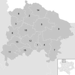
Neighboring districts
.svg)
Administrative division
The Waidhofen an der Thaya district is divided into:
- 15 municipalities ,
- including 3 cities and
- 10 market towns.
In 2007, the 15 municipalities merged to form the small region of the future region Thayaland .

- Regions in the table are small regions in Lower Austria
| local community | location | Ew | km² | Ew / km² | Judicial district | region | Type | Metadata |
|---|---|---|---|---|---|---|---|---|
Dietmanns
|

|
1,039 | 6.88 | 151 | Waidhofen an der Thaya | Thayaland | market community |
According to code: 32202 |
Dobersberg
|

|
1,572 | 47.57 | 33 | Waidhofen an der Thaya | Thayaland | market community |
According to code: 32203 |
Gastern
|

|
1,194 | 24.98 | 48 | Waidhofen an der Thaya | Thayaland | market community |
According to code: 32206 |
Groß-Siegharts
|

|
2,721 | 44.26 | 61 | Waidhofen an der Thaya | Thayaland | urban community |
Acc. To code: 32207 |
Karlstein on the Thaya
|

|
1,481 | 48.88 | 30th | Waidhofen an der Thaya | Thayaland | market community |
According to code: 32209 |
Kautzen
|

|
1,112 | 35.38 | 31 | Waidhofen an der Thaya | Thayaland | market community |
According to code: 32210 |
Ludweis-Aigen
|

|
905 | 51.19 | 18th | Waidhofen an der Thaya | Thayaland | market community |
Acc. To code: 32212 |
Pfaffenschlag near Waidhofen an der Thaya
|

|
923 | 29.74 | 31 | Waidhofen an der Thaya | Thayaland | local community |
According to code: 32214 |
Raabs an der Thaya
|

|
2,635 | 134.65 | 20th | Waidhofen an der Thaya | Thayaland | urban community |
Acc. To code: 32216 |
Thaya
|

|
1,388 | 43.3 | 32 | Waidhofen an der Thaya | Thayaland | market community |
Acc. To code: 32217 |
Vitis
|

|
2,655 | 55.53 | 48 | Waidhofen an der Thaya | Thayaland | market community |
According to code: 32219 |
Waidhofen an der Thaya
|

|
5,365 | 46.05 | 117 | Waidhofen an der Thaya | Thayaland | urban community |
According to code: 32220 |
Waidhofen an der Thaya-Land
|

|
1,270 | 32.47 | 39 | Waidhofen an der Thaya | Thayaland | local community |
According to code: 32221 |
Waldkirchen an der Thaya
|

|
501 | 42.69 | 12 | Waidhofen an der Thaya | Thayaland | market community |
According to code: 32222 |
Windigsteig
|

|
921 | 25.58 | 36 | Waidhofen an der Thaya | Thayaland | market community |
According to code: 32223 |
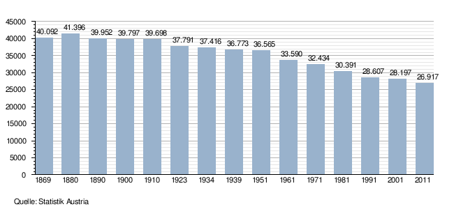
Population development
See also
- Listed objects in the Waidhofen an der Thaya district
- List of natural monuments in the Waidhofen an der Thaya district
Web links
Individual evidence
- ↑ Reichsgesetzblatt No. 44/1868
- ↑ Reichsgesetzblatt No. 123/1899
- ^ Law on the Development of the Administration in the Ostmark , April 14, 1939
Statutory cities: Krems an der Donau | St. Pölten | Waidhofen an der Ybbs | Wiener Neustadt
Administrative districts: Amstetten | Bathing | Bruck an der Leitha | Gänserndorf | Gmünd | Hollabrunn | Horn | Korneuburg | Krems | Lily field | Melk | Mistelbach | Mödling | Neunkirchen | St. Pölten | Scheibbs | Tulln | Waidhofen an der Thaya | Wiener Neustadt | Zwettl
Former districts: Floridsdorf area | Groß-Enzersdorf | Hernals | Hietzing | Hietzing area | Pöggstall | Six house | Währing | Vienna Area
Former branch: Pöggstall
Coordinates: 48 ° 49 ' N , 15 ° 17' E