
District of Gmünd
| location | |
|---|---|
  |
|
| Basic data | |
| state | Lower Austria |
| NUTS III region | AT-124 |
| Administrative headquarters | Gmuend |
| surface | 787 km² |
| Residents | 36,553 (January 1, 2020) |
| Population density | 46 inhabitants / km² |
| License Plate | GD |
| District Commission | |
| District Captain | Stefan Grusch |
| website |
www.noel.gv.at/ Bezirke / BH-Gmuend |
| map | |
  |
|
The Gmünd district is an administrative district of the Province of Lower Austria .
history
The district was formed in 1899 from the former district of Weitra, which had previously been added to the district of Zwettl , and the former districts of Schrems and Litschau , which had previously been added to the district of Waidhofen an der Thaya . The city of Gmünd itself was under the administrative district of Schrems until 1867 and was then assigned to the district of Waidhofen an der Thaya.
In 1920, the district was reduced to include the peripheral areas that became part of the new state of Czechoslovakia after the Treaty of Saint-Germain . These were the district of Gmünd Bahnhof (today České Velenice ) with the then Gmünder Hauptbahnhof and the villages of Erdweis ( Nová Ves nad Lužnicí ), Zuggers ( Krabonoš ) and Rottenschachen ( Rapšach ). The Waldviertel narrow-gauge railways branching off from the Franz-Josefs-Bahn in Gmünd therefore had to leave the new starting point at Gmünd, Lower Austria. (until then Gmünd Stadt ) in the vicinity should be re-routed in order to run only on Austrian territory.
geography
The district is located in the northwest of the state, on the border with the Czech Republic . In terms of landscape it belongs to the Waldviertel and it also belongs to the main spatial planning region of the Waldviertel .
Neighboring districts
.svg)
Administrative division
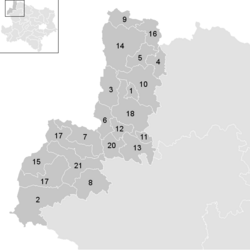
The Gmünd district is divided into 21 municipalities , including five towns and eleven market communities.

- Regions in the table are small regions in Lower Austria
| local community | location | Ew | km² | Ew / km² | Judicial district | region | Type | Metadata |
|---|---|---|---|---|---|---|---|---|
Amali village eel fishing
|

|
1.108 | 8.04 | 138 | Gmünd in Lower Austria | Waldviertel city country | market community |
According to code: 30902 |
Bad Großpertholz
|

|
1.310 | 82.47 | 16 | Gmünd in Lower Austria | Lainsitztal | market community |
According to code: 30910 |
Brand-Nagelberg
|

|
1,512 | 36.7 | 41 | Gmünd in Lower Austria | Waldviertel city country | market community |
According to code: 30903 |
Eggern
|

|
680 | 20.23 | 34 | Gmünd in Lower Austria | Waldviertel North | market community |
Acc. To code: 30904 |
Ice yarn
|

|
680 | 22.52 | 30th | Gmünd in Lower Austria | Waldviertel North | market community |
According to code: 30906 |
Gmuend
|

|
5,338 | 25.18 | 212 | Gmünd in Lower Austria | Waldviertel city country | urban community |
According to code: 30908 |
Grossdietmanns
|

|
2.214 | 39.93 | 55 | Gmünd in Lower Austria | Waldviertel city country | market community |
Acc. To code: 30909 |
Großschönau
|

|
1,209 | 41.95 | 29 | Gmünd in Lower Austria | Lainsitztal | market community |
Acc. To code: 30912 |
Haugschlag
|

|
481 | 22.65 | 21st | Gmünd in Lower Austria | Waldviertel North | local community |
According to code: 30915 |
Heidenreichstein
|

|
3,922 | 58.44 | 67 | Gmünd in Lower Austria | Waldviertel North | urban community |
According to code: 30916 |
Hirschbach
|

|
576 | 7.89 | 73 | Gmünd in Lower Austria | Waldviertel city country | market community |
Acc. To code: 30917 |
Hoheneich
|

|
1,395 | 15.57 | 90 | Gmünd in Lower Austria | Waldviertel city country | market community |
According to code: 30920 |
Kirchberg am Walde
|

|
1,307 | 37.8 | 35 | Gmünd in Lower Austria | Waldviertel city country | market community |
Acc. To code: 30921 |
Litschau
|

|
2.176 | 81.08 | 27 | Gmünd in Lower Austria | Waldviertel North | urban community |
Acc. To code: 30925 |
Harbach mud bath
|

|
734 | 35.54 | 21st | Gmünd in Lower Austria | Lainsitztal | local community |
Acc. To code: 30913 |
Reingers
|

|
617 | 24.94 | 25th | Gmünd in Lower Austria | Waldviertel North | local community |
Acc. To code: 30929 |
Schrems,_AUT_-_Coat_of_arms.png)
|

|
5,383 | 60.81 | 89 | Gmünd in Lower Austria | Waldviertel city country | urban community |
Acc. To code: 30935 |
St. Martin
|

|
1,091 | 49.39 | 22nd | Gmünd in Lower Austria | Lainsitztal | market community |
Acc. To code: 30932 |
Unserfrau-Altweitra
|

|
981 | 40.21 | 24 | Gmünd in Lower Austria | Lainsitztal | local community |
Acc. To code: 30939 |
Waldenstein
|

|
1,194 | 22.72 | 53 | Gmünd in Lower Austria | Waldviertel city country | local community |
Acc. To code: 30940 |
Weitra
|

|
2,645 | 52.66 | 50 | Gmünd in Lower Austria | Lainsitztal | urban community |
Acc. To code: 30942 |
Population development

See also
Web links
Individual evidence
- ↑ Announcement of the Ministry of the Interior of July 15, 1899 , RGBl. No. 123/1899.
Statutory cities: Krems an der Donau | St. Pölten | Waidhofen an der Ybbs | Wiener Neustadt
Administrative districts: Amstetten | Bathing | Bruck an der Leitha | Gänserndorf | Gmünd | Hollabrunn | Horn | Korneuburg | Krems | Lily field | Melk | Mistelbach | Mödling | Neunkirchen | St. Pölten | Scheibbs | Tulln | Waidhofen an der Thaya | Wiener Neustadt | Zwettl
Former districts: Floridsdorf area | Groß-Enzersdorf | Hernals | Hietzing | Hietzing area | Pöggstall | Six house | Währing | Vienna Area
Former branch: Pöggstall
Coordinates: 48 ° 46 ' N , 14 ° 59' E