Bobrynez
| Bobrynez | ||
| Бобринець | ||

|
|
|
| Basic data | ||
|---|---|---|
| Oblast : | Kirovohrad Oblast | |
| Rajon : | Bobrynez district | |
| Height : | 140 m | |
| Area : | 18.13 km² | |
| Residents : | 10,846 (2018) | |
| Population density : | 598 inhabitants per km² | |
| Postcodes : | 27200 | |
| Area code : | +380 5257 | |
| Geographic location : | 48 ° 3 ' N , 32 ° 9' E | |
| KOATUU : | 3525855100 | |
| Administrative structure : | 1 city | |
| Mayor : | Anatoly Mykolaiowytsch Mohylenko | |
| Address: | вул. Орджонікідзе 80 27200 м. Бобринець |
|
| Website : | http://bobrynec.org.ua | |
| Statistical information | ||
|
|
||
Bobrynez ( Ukrainian Бобринець ; Russian Бобринец Bobrinez ) is a city in the center of Ukraine with 10,800 inhabitants (2018). It is located in the south of the Kirovohrad Oblast and is the administrative center of the raion of the same name, 53 km south of the Oblast capital Kropywnyzkyj .
history
The first mention of the village comes from 1767 (as Mali Bobrinez ). In 1816 the city already had 1910 inhabitants and received city status in 1828. Around 1900 the city had 18,470 inhabitants, of whom 3,481 were Jews.
The city was occupied by Wehrmacht troops from August 6, 1941 to March 16, 1944 . During the German occupation, the city was the capital of the Bobrinez district in the Nikolajew general district within the Reichskommissariat Ukraine .
coat of arms
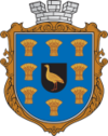
The city's original coat of arms from 1847 was divided into two parts. In the upper area was the emblem of the Kherson Province, to which the city then belonged. The lower part depicts bustards surrounded by sheaves of corn . At that time, unlike today, the bustards were common birds around the city. The sheaves symbolize agriculture, the most important business area for the residents. Today's coat of arms ties in with the historical, but without showing subordination to a province, but rather crowned by a wall crown.
population
| 1816 | 1835 | 1900 | 1959 | 1970 | 1989 | 2001 | 2005 | 2016 |
|---|---|---|---|---|---|---|---|---|
| 1.910 | 6,038 | 18,470 | 13,056 | 11 908 | 12,869 | 12,300 | 11,762 | 10,992 |
Sources: 1816–1900, 1989–2013.
Personalities
- Pjotr Jefimowitsch Todorowski (1925–2013), Ukrainian-Russian director, screenwriter and composer
- David Grigoryevich Gerschfeld (1911–2005), Ukrainian-Moldovan composer and university professor
Rajon
Bobrynez is the administrative seat of the Rajons of the same name. The Bobrynez district (Ukrainian Бобринецький район ) has 31,593 inhabitants and an area of 1,496 km². The population density is 21 people per km². The birthplace of Leon Trotsky , the village of Bereslavka, lies in the Rajon .
Web links
Individual evidence
- ↑ a b c Population figures on pop-stat.mashke.org
- ↑ Jewish population on jewishgen.org (English)
- ↑ a b City history ( Memento of the original from March 31, 2013 in the Internet Archive ) Info: The archive link was inserted automatically and has not yet been checked. Please check the original and archive link according to the instructions and then remove this notice. (Ukrainian)
- ↑ Coat of arms of the city ( Memento of the original from April 4, 2013 in the Internet Archive ) Info: The archive link was inserted automatically and has not yet been checked. Please check the original and archive link according to the instructions and then remove this notice. (Ukrainian)


