Bromberg (Schönbuch)
| Bromberg | ||
|---|---|---|
|
The Bromberg in Schönbuch |
||
| height | 583.6 m above sea level NHN | |
| location | near Altdorf ; District of Böblingen , Baden-Württemberg ( Germany ) | |
| Mountains | Schönbuch | |
| Coordinates | 48 ° 35 '39 " N , 8 ° 59' 48" E | |
|
|
||
| rock | Keuper | |


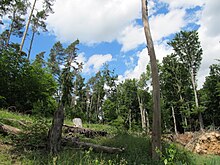
The Bromberg near Altdorf in the Boeblingen district is 583.6 m above sea level. NHN the highest point in the Schönbuch , a mountainous forest area in the southern German Keuperbergland in Baden-Württemberg .
The predominantly wooded mountain ridge of the Bromberg lies in the western part of the Schönbuch, entirely within the boundaries of the Schönbuch Nature Park , and extends for about four kilometers from northwest to southeast. On the south side, the mountain drops quite steeply into the Goldersbach valley 150 meters below . On the other hand, seen from the north, from Altdorf, it is not very prominent.
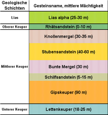
The Bromberg plateau is formed by a top layer of Rhätsandstein . On the south side, the Goldersbachtal cuts through all the Keuper strata down to the reed sandstone . The vegetation of the plateau is reminiscent of the high altitudes of the northern Black Forest .
geography
location
The Bromberg rises in the center of Schönbuch about halfway as the crow flies between Entringen in the southwest and Weil in the northeast. Its highest point is about four kilometers south of the village center of on the Schönbuch glade located Altdorf , where the terrain rises gradually to the summit.
In the transition region from Bromberg to the northwest followed Kirnberg ( 558.9 m ) rises near the forest path Eselstrittweg of from thence east-north flowing Aich influx Sheikh . Between the Bromberg and the 1.6 km south of the Steingart ( 566.1 m ), the second highest mountain in the Schönbuch, the Great Goldersbach flows as the right source brook of the Goldersbach in a west-east direction . Between the two mountains, the creek has dug itself into the landscape about 155 meters deep at the forest path and pedestrian bridge that spans the Diebsteigbrücke ( 428.5 m ), measured from the Brombergkuppe to the creek bed. East of the Bromberg flows with the small Goldersbach fed by the Ochsenbach , the left source brook of the Goldersbach. They all belong to the Neckar catchment area .
Because there are no roads leading to Bromberg, it can only be reached on forest paths. There is a water container on the Brombergebene near the Schneiderweg .
Natural allocation
The Bromberg belongs to the natural spatial main unit group Swabian Keuper-Lias-Land (No. 10), in the main unit Schönbuch and Glemswald (104) and in the subunit Schönbuch (104.1) to the natural area Südlicher Schönbuch (104.12). To the north, the landscape drops into the natural area of Holzgerlinger Platte (104.14).
geology
As is typical for the higher elevations of the western Schönbuch, the uppermost layer is formed by the relatively resistant Rhätsandstein . Only in a few places is the lowest layer of the Jura , the Black Jura, still on top . The Goldersbachtal to the south cuts through all the Keup layers up to the Gipskeuer . On the southern slope of the Bromberg, seen from above, there is initially a rather short section of marl , then quite extensive slopes with parlor sandstone and finally the upper and lower colored marl on the slopes above the valley floor.
The so-called Bromberg Gap , a fault running from Hildrizhausen to Bebenhausen , extends on the north side of the Bromberg . At this important tectonic fault line, the northern Schönbuchscholle is so much lower than the higher southern one that the geologically younger layers of the Black Jura have been extensively preserved in the lower, northern layers. These soils, which are partly covered with a loosening plate, are very fertile and must have been cleared early on. Today there are the places Hildrizhausen, Altdorf , Holzgerlingen and Weil im Schönbuch, which belong to the so-called Schönbuch clearing .
history
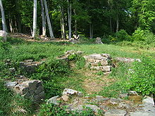
At the southeast end of Brombergebene are besides thereat of Kapellbrunnen to around 510 m the remains of a hermitage (Hermitage), former chapel called. It dates from the late Middle Ages (13th to 15th centuries), was abandoned after the introduction of the Reformation in the Duchy of Württemberg (from 1534) , according to the information board on site, and consisted of a hermitage (small residential building of a monk , nun or hermit ) and a chapel . In 1974, the walls made of existing Rhät sandstone were exposed.
The Bromberg is part of the Schönbuch Nature Park, founded in 1972 .
Until it was destroyed by a storm at the end of 1888, there was a replacement observation tower between two tall trees at the highest point of the Bromberg for a few decades, "Two Oaks", from where you could see very far into the Black Forest.
For example, on February 28 and March 1, 1990, hurricane Wiebke passed through Germany and left damage in Schönbuch. According to the inscription, one on the Bromberg on forest road Weinweg erected memorial stone destroyed the storm of the century Wiebke, of the state forestry office on March 1 Bebenhausen raged, and the bark beetle disaster of dry and hot in subsequent years , it is there, literally, about 350 hectares (ha ) mostly spruce forests.
On December 26, 1999, hurricane Lothar passed through Germany, among other places. It was even stronger than Wiebke , caused a strong wind break in Schönbuch, and also on Bromberg, and severely damaged the remains of the local hermitage. According to an investigation carried out by the Eberhard Karls University of Tübingen on behalf of the State Monuments Office of Baden-Württemberg , the remains of the hermitage could be restored in 2004 as a stone.
Protected areas
The Bromberg belongs completely to the northwestern area of the multi-part, designated in 2005 and 112.4713 km² Fauna-Flora-Habitat area Schönbuch (FFH no. 7420-341) and multi-part, since 2007 existing and 153.6203 km² bird sanctuary Schönbuch (VSG No. 7420-441). A large part of the Schönbuch landscape protection area, which was designated in 1961 and covers 36.82 km² ( CDDA no. 324243; LSG no. 1.15.016), is located on the mountain .
On the southern slope of the Bromberg, on its flank to the Großer Goldersbach below the Falkenkopf ( 532.2 m ), the 33.9 hectare Schonwald Diebsteig (area no. 200011) has been located since 1972 . The objective of this forest protection area is to preserve the Hutewald forest, which was created due to former forest pastures, consisting of loose oak , beech and hornbeam trees. For this purpose, naturally excreted trunks are usually left to their own devices, the natural deciduous rejuvenation is protected from deer biting, and softwood sections are converted into hardwood over the long term.
In addition, the 19.6 hectare Silbersandgrube ban forest (area no. 100066) has existed on the plateau in the south -eastern part of the Bromberg since 1993 .
Monuments
Birch Lake
On the Brombergebene, about 1.3 km east of the hilltop northwest of the protected area Bannwald Silbersandgrube, is the small Birkensee . It is located on the Schaichhof Allee forest path at an altitude of around 565 m . Due to the rare plant communities that occur there, it has been designated as a 2.3 hectare natural monument of the Birkensee wetlands since 1993 . It is a transitional moor in the stage between low and high moor .
The 3.4 hectare Altbuchenhain Kapellenberg natural monument has been in the south-eastern part of the Brombergebene range since 1993 . It lies above the Steiniger Weg forest path at an altitude of 500 to 535 m and contains the hermitage, the former chapel and the chapel fountain ; a little outside of this natural monument stands the Haugeiche below the stony path . Also below this forest path, about 700 m further north-northeast near the Hubertus oak, is the 0.4 hectare, elongated and narrow natural monument chain of dolines in Glashau with 13 dolines .
Others
On and on the Bromberg, in addition to the previously mentioned memorial stone for Hurricane Wiebke , there are old memorial stones that remind of events of a partly unknown type: Dürrstein (on the Steinigen Weg ; near the Falkenkopf ), Entringer Stein (at the intersection of Diebsteig , Entringer Allee and Schneißenweg ), Erbachstein (on Schnapsallee above Ochsenbach), Eselstritt (legendary stone in the ground with a horseshoe-shaped imprint; on Eselstrittweg near the fork oak ) and Hirschstein (on Schnapsallee , northwest of Erbachstein ).
In some places there are striking trees in the Bromberg forest, some of which are designated as natural monuments (ND): fork oak ( 551.9 m ; on Eselstritt in the transition area to Kirnberg ), hauge oak (below the former chapel ), Hubertus oak (on Steinigen Weg ), royal oak (on Kleine Goldersbach ), Linde (on Schneiderweg ), Schinderbuche (east of the hilltop) and Zwei Eichen (on Degerlocher Allee ). In a side valley above the Ochsenbachtal is the cultural monument of the Roman pottery kiln and not far to the northwest of it is the schnapps oak ( 513.2 m ).
See also
Literature and map
- Dieter Buck: The big book from Schönbuch: nature, culture, history, places. Silberbuch-Verlag, Tübingen 2000, ISBN 3-87407-334-3 .
- Ingrid Gamer-Wallert , Sönke Lorenz (ed.): The beautiful book: man and forest in past and present. Attempto, Tübingen 1998, ISBN 3-89308-292-1 .
- Land surveying office Baden-Württemberg: Tübingen district, leisure map; Official map of the Schönbuch Nature Park . 2nd edition, Stuttgart 2007, ISBN 978-3-89021-710-9 .
Individual evidence
- ↑ a b Map service "Protected areas in Germany" of the Federal Agency for Nature Conservation , accessed on May 31, 2019
- ↑ Dieter Buck: The great book from the beautiful book. P. 128 (see section literature )
- ^ Friedrich Huttenlocher , Hansjörg Dongus : Geographical land survey: The natural spatial units on sheet 170 Stuttgart. Federal Institute for Regional Studies, Bad Godesberg 1949, revised 1967. → Online map (PDF; 4.0 MB)
- ^ A b c Hermann Grees: The beautiful book as a natural space and cultural landscape. In: Wallert, Lorenz (ed.): The beautiful book: man and forest in history and present. Pp. 16–33 (see section literature )
- ↑ Dieter Buck: The great book from the beautiful book. P. 45 (see section literature )
- ↑ Map services of the Federal Agency for Nature Conservation ( information )
- ↑ a b c d State Institute for the Environment, Measurements and Nature Conservation, Baden-Württemberg


