
Capelle-lès-Hesdin
| Capelle-lès-Hesdin | ||
|---|---|---|

|
|
|
| region | Hauts-de-France | |
| Department | Pas-de-Calais | |
| Arrondissement | Montreuil | |
| Canton | Auxi-le-Château | |
| Community association | Sept Vallées | |
| Coordinates | 50 ° 21 ′ N , 2 ° 0 ′ E | |
| height | 65-131 m | |
| surface | 5.56 km 2 | |
| Residents | 485 (January 1, 2017) | |
| Population density | 87 inhabitants / km 2 | |
| Post Code | 62140 | |
| INSEE code | 62212 | |
 Town hall (Mairie) of Capelle-lès-Hesdin |
||

Capelle-lès-Hesdin is a French municipality with 485 inhabitants (at January 1, 2017) in the department of Pas-de-Calais in the region of Hauts-de-France (before 2016: Nord-Pas-de-Calais ). It belongs to the arrondissement of Montreuil and the canton of Auxi-le-Château (until 2015: canton of Hesdin ).
Neighboring municipalities of Capelle-lès-Hesdin are Bouin-Plumoison in the north-west, Marconnelle in the north, Marconne in the north-east, Mouriez in the west, Brévillers in the east and Guigny in the south.
Population development
| year | 1962 | 1968 | 1975 | 1982 | 1990 | 1999 | 2007 | 2014 |
| Residents | 300 | 307 | 317 | 339 | 367 | 407 | 449 | 454 |
Attractions
- Nativité-de-Notre-Dame church
- War memorial
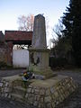
- Calvary
War memorial

Calvary


Web links
Commons : Capelle-lès-Hesdin - Collection of images, videos and audio files