Lépine
| Lépine | ||
|---|---|---|

|
|
|
| region | Hauts-de-France | |
| Department | Pas-de-Calais | |
| Arrondissement | Montreuil | |
| Canton | Berck | |
| Community association | Deux Baies en Montreuillois | |
| Coordinates | 50 ° 23 ′ N , 1 ° 44 ′ E | |
| height | 3–59 m | |
| surface | 10.82 km 2 | |
| Residents | 273 (January 1, 2017) | |
| Population density | 25 inhabitants / km 2 | |
| Post Code | 62170 | |
| INSEE code | 62499 | |
Lépine is a French municipality with 273 inhabitants (as of January 1 2017) in the department of Pas-de-Calais in the region of Hauts-de-France (before 2016: Nord-Pas-de-Calais ). It belongs to the arrondissement of Montreuil and the canton of Berck (until 2015: canton of Montreuil ). The inhabitants are called Lépinois .
geography
Lépine is near the Opal Coast of the English Channel . Lépine is surrounded by the neighboring communities of Wailly-Beaucamp in the north, Roussent in the east, Nempont-Saint-Firmin in the south, Tigny-Noyelle in the south-west, Conchil-le-Temple in the west and Verton in the north-west.
The former route nationale 1 (today's D901) runs through the municipality .
Population development
| year | 1962 | 1968 | 1975 | 1982 | 1990 | 1999 | 2006 | 2013 |
| Residents | 367 | 319 | 268 | 279 | 296 | 297 | 283 | 271 |
| Source: Cassini and INSEE | ||||||||
Attractions
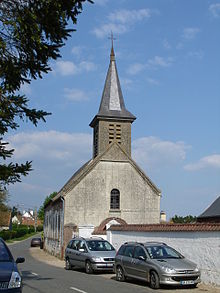
- Nativité-Notre-Dame church from the 15th century
- 19th century castle Le Puits-Bérault
Web links
Commons : Lépine (Pas-de-Calais) - Collection of images, videos and audio files

