
Wailly-Beaucamp
| Wailly-Beaucamp | ||
|---|---|---|

|
|
|
| region | Hauts-de-France | |
| Department | Pas-de-Calais | |
| Arrondissement | Montreuil | |
| Canton | Berck | |
| Community association | Deux Baies en Montreuillois | |
| Coordinates | 50 ° 25 ′ N , 1 ° 44 ′ E | |
| height | 18-68 m | |
| surface | 14.33 km 2 | |
| Residents | 1,004 (January 1, 2017) | |
| Population density | 70 inhabitants / km 2 | |
| Post Code | 62170 | |
| INSEE code | 62870 | |

Wailly-Beaucamp is a commune in the French Pas-de-Calais in the region of Hauts-de-France . Until the reorganization of the French cantons in 2015, it belonged to the canton of Montreuil in the arrondissement of the same name and then came to the canton of Berck .
Neighboring municipalities are Airon-Saint-Vaast and Campigneulles-les-Grandes in the north-west, Campigneulles-les-Petites in the north, Écuires in the north-east, Boisjean in the east, Lépine in the south and Verton and Rang-du-Fliers in the west.
The Route nationale 1 leads via Wailly-Beaucamp.
Population development
| year | 1891 | 1896 | 1901 | 1906 | 1911 | 1921 | 1926 | 1931 | 1936 | 1946 | 1954 | 1962 | 1968 | 1975 | 1982 | 1990 | 1999 | 2005 | 2010 | 2014 |
|---|---|---|---|---|---|---|---|---|---|---|---|---|---|---|---|---|---|---|---|---|
| population | 571 | 578 | 580 | 537 | 543 | 533 | 505 | 531 | 508 | 528 | 489 | 500 | 514 | 598 | 677 | 741 | 779 | 900 | 992 | 1020 |
| source |
Attractions
- Saint-Pierre church
- Dame de la Bonne Mort chapel
- former train station
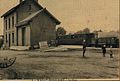
Former train station on the route from Aire-sur-la-Lys to Berck -Plage
former station building


Web links
Commons : Wailly-Beaucamp - collection of images, videos and audio files
Individual evidence
- ^ Wailly-Beaucamp - Notice Communale. Retrieved November 20, 2017 .
- ↑ Populations légales 2010 − Commune de Wailly-Beaucamp (62870) | Insee. Retrieved November 20, 2017 (French).