
Wambercourt
| Wambercourt | ||
|---|---|---|
.svg)
|
|
|
| region | Hauts-de-France | |
| Department | Pas-de-Calais | |
| Arrondissement | Montreuil | |
| Canton | Auxi-le-Château | |
| Community association | Sept Vallées | |
| Coordinates | 50 ° 26 ' N , 2 ° 1' E | |
| height | 35-118 m | |
| surface | 6.06 km 2 | |
| Residents | 245 (January 1, 2017) | |
| Population density | 40 inhabitants / km 2 | |
| Post Code | 62140 | |
| INSEE code | 62871 | |

Wambercourt is a commune in the French Pas-de-Calais in the region of Hauts-de-France . It belongs to the canton of Auxi-le-Château in the arrondissement of Montreuil .
Neighboring communities are Lebiez in the north-west, Fressin in the north-east, Wamin in the south-east and Cavron-Saint-Martin in the south-west.
Population development
| year | 1962 | 1968 | 1975 | 1982 | 1990 | 1999 | 2008 | 2014 |
|---|---|---|---|---|---|---|---|---|
| Residents | 179 | 173 | 154 | 172 | 181 | 198 | 228 | 253 |
Attractions
- Saint-Denis church
- Brick chapel
- Quarry stone chapel
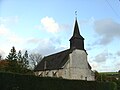
Saint-Denis church

Brick chapel


Web links
Commons : Wambercourt - collection of images, videos and audio files