Longvilliers (Pas-de-Calais)
| Longvilliers | ||
|---|---|---|

|
|
|
| region | Hauts-de-France | |
| Department | Pas-de-Calais | |
| Arrondissement | Montreuil | |
| Canton | Étaples | |
| Community association | Deux Baies en Montreuillois | |
| Coordinates | 50 ° 33 ' N , 1 ° 44' E | |
| height | 19-120 m | |
| surface | 10.99 km 2 | |
| Residents | 247 (January 1, 2017) | |
| Population density | 22 inhabitants / km 2 | |
| Post Code | 62630 | |
| INSEE code | 62527 | |
| Website | http://www.longvilliers.fr/ | |
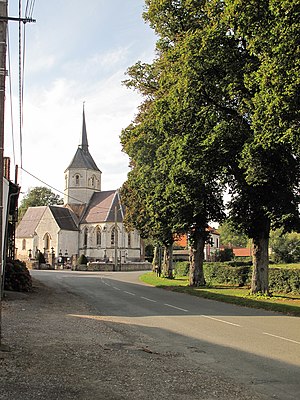
 Saint-Nicolas church |
||
Longvilliers is a French municipality with 247 inhabitants (at January 1, 2017) in the department of Pas-de-Calais in the region of Hauts-de-France (before 2016 Nord-Pas-de-Calais ). It belongs to the arrondissement of Montreuil and the canton of Étaples . The inhabitants are called Longvillois .
Neighboring communities of Longvilliers are Frencq in the north-west, Cormont in the north, Bernieulles in the north-east, Tubersent in the west, Inxent in the east, Maresville in the south-west, Bréxent-Énocq in the south and Recques-sur-Course in the south-east.
Population development
| year | 1962 | 1968 | 1975 | 1982 | 1990 | 1999 | 2007 | 2014 |
| Residents | 294 | 297 | 263 | 243 | 244 | 249 | 229 | 256 |
Attractions
- Saint-Nicolas church
- Ruins of the castle from the 16th century
Web links
Commons : Longvilliers - collection of images, videos and audio files
