Zoteux
|
Zoteux Zotiu / Ages |
||
|---|---|---|

|
|
|
| region | Hauts-de-France | |
| Department | Pas-de-Calais | |
| Arrondissement | Montreuil | |
| Canton | Lumbres | |
| Community association | Haut Pays du Montreuillois | |
| Coordinates | 50 ° 37 ′ N , 1 ° 53 ′ E | |
| height | 130-172 m | |
| surface | 7.34 km 2 | |
| Residents | 615 (January 1, 2017) | |
| Population density | 84 inhabitants / km 2 | |
| Post Code | 62650 | |
| INSEE code | 62903 | |
 Location of Zoteux in the arrondissement of Montreuil |
||
Zoteux ( Picard Zotiu ; West Flemish Teralteren ) is a French municipality with 615 inhabitants (at January 1, 2017) in the Pas-de-Calais in the region of Hauts-de-France . It belongs to the Arrondissement of Montreuil and the Haut Pays du Montreuillois municipality . The residents call themselves Zotelois .
geography
Zoteux is located 20 kilometers southeast of Boulogne-sur-Mer and about 22 kilometers east of the English Channel coast . In addition to the village of Zoteux, the municipality consists of the districts Fauchelles, Bout de Dessous, Les Mortiers and Les Correaux . The neighboring communities are Bécourt in the northeast, Bourthes in the east, Bezinghem in the south and west and Doudeauville in the northwest. The 734 hectare municipal area on the edge of the Regional Nature Park Caps et Marais d'Opale has no surface running water and is completely forest-free. Precipitation seeping into the ground emerges southeast of Zoteux and flows off via the Aa .
history
Zoteux was built near the intersection of seven Roman roads. Graves, coins and other artifacts from the Gallo-Roman period were found on the territory of the municipality. There were two moths in the districts of Les Correaux and Les Mortiers , the weathered remains of which can still be seen today.
There are two theories about the origin of the place name: The first sees the same origin as the Flemish name Zottegem with the root word zout- (= salt ). The origin of the Latin word Altaria (altar) is seen as more likely . It refers to early cult sites at the intersection of seven Roman roads. Over the centuries the name has been distorted more and more. In 1150 the name Altaribus appeared, around 1300 it became Auteus . The current spelling of Zoteux emerged via Auteux (approx. 1656) and Les Hosteux . In 1466 Zoteux was part of the Bailiwick of Desvres and belonged to Robert Thubeauville . One of the last lords of Zoteux before the revolution was Antoine Roussel .
Population development
| year | 1962 | 1968 | 1975 | 1982 | 1990 | 1999 | 2006 | 2017 | |
| Residents | 298 | 299 | 322 | 390 | 404 | 390 | 478 | 615 | |
| Sources: Cassini and INSEE | |||||||||
Attractions
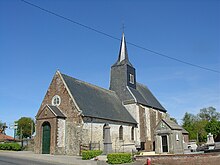
The church of St. Peter ( Saint-Pierre ) dates from the 15th century, the holy water stoups from the late 17th century. One of the church bells from 1514 was placed on the village square. Opposite the church are the remains of a castle that was unfinished due to the French Revolution and is now used as a barn. A wayside shrine in the Fauchelles district was built in 1824 at the intersection of seven former Roman roads ( Carrefour des Sept voies romaines ). You can find the inscriptions of the destinations at that time:
- to Desvres via Courteau
- via Attin to Canche
- to Amiens via Auxi-le-Château
- via Saint-Pol to Arras
- to Thérouanne
- to Arques
- to Leulinghem via Senlecques and Licques
The war memorial ( Monument aux morts ) was erected in 1921.
Economy and Infrastructure
There are 25 farms in the municipality of Zoteux (cereal cultivation, dairy farming, breeding of horses, cattle, sheep and goats).
The D 343 from Desvres to Hucqueliers runs through the municipality of Zoteux . There are further road connections to the four neighboring communities.
supporting documents
- ↑ Zoteux on www.echo62.com ( Memento of March 4, 2016 in the Internet Archive ) (French)
- ↑ Zoteux on cassini.ehess.fr
- ↑ Zoteux on insee.fr
- ↑ Farms on annuaire-mairie.fr (French)

