Mouriez
| Mouriez | ||
|---|---|---|

|
|
|
| region | Hauts-de-France | |
| Department | Pas-de-Calais | |
| Arrondissement | Montreuil | |
| Canton | Auxi-le-Château | |
| Community association | Sept Vallées | |
| Coordinates | 50 ° 20 ′ N , 1 ° 57 ′ E | |
| height | 30-127 m | |
| surface | 15.72 km 2 | |
| Residents | 249 (January 1, 2017) | |
| Population density | 16 inhabitants / km 2 | |
| Post Code | 62140 | |
| INSEE code | 62596 | |
 Town hall (Mairie) and school in Mouriez |
||
Mouriez is a French municipality with 249 inhabitants (as of January 1 2017) and part of the Canton of Auxi-le-Château (2015: Canton Hesdin ) in Arrondissement Montreuil in the department of Pas-de-Calais in the region of Hauts-de-France (before 2016: Nord-Pas-de-Calais ). The inhabitants are called Richarimontois .
geography
Mouriez is about 48 kilometers south-southeast of Boulogne-sur-Mer . Mouriez is surrounded by the neighboring communities of Aubin-Saint-Vaast in the north, Bouin-Plumoison in the northeast, Capelle-lès-Hesdin in the east, Guigny in the southeast, Raye-sur-Authie and Dompierre-sur-Authie in the south, Tortefontaine in the west as well Gouy-Saint-André in the northwest.
population
| Population development | ||||||||
|---|---|---|---|---|---|---|---|---|
| year | 1962 | 1968 | 1975 | 1982 | 1990 | 1999 | 2006 | 2013 |
| Residents | 408 | 379 | 321 | 313 | 287 | 241 | 245 | 248 |
| Source: Cassini and INSEE | ||||||||
Attractions
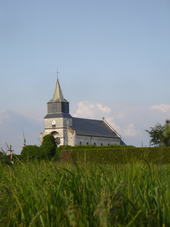
- Notre-Dame-de-la-Nativité church, built in 1674, rebuilt in 1864
Personalities
- Albert Tréca (1917-2004), diplomat
Web links
Commons : Mouriez - collection of images, videos and audio files

